Difference between revisions of "2009-08-06 41 -70"
From Geohashing
imported>Sara m (expand Subst:Expedition) |
m (per Renaming Proposal) |
||
| (3 intermediate revisions by 2 users not shown) | |||
| Line 1: | Line 1: | ||
| − | + | [[Image:{{{image|2009-08-06_41_-70_gps.jpg}}}|thumb|left]] | |
| − | |||
| − | |||
| − | [[Image:{{{image| | ||
| − | |||
{{meetup graticule | {{meetup graticule | ||
| lat=41 | | lat=41 | ||
| Line 14: | Line 10: | ||
== Location == | == Location == | ||
| + | In the middle of a residential street in Plymouth, Massachusetts. | ||
== Participants == | == Participants == | ||
| + | [[User:Sara|Sara]] | ||
| + | |||
| + | == Planning == | ||
| − | + | Good [[Cape Cod, Massachusetts|Cape Cod]] hashpoint<br /> | |
| + | And I'm nearby - in Cambridge --<br /> | ||
| + | Devirginalize! | ||
| + | The challenging part:<br /> | ||
| + | I'm scared to drive in Boston -- <br /> | ||
| + | Wait 'til Rush Hour's done. | ||
== Expedition == | == Expedition == | ||
| + | Rare sight on [http://www.bostonroads.com/roads/southeast/ xway]:<br /> | ||
| + | An Alaska license plate!<br /> | ||
| + | (Pic came out blurry.) | ||
| + | |||
| + | Drove about an hour<br /> | ||
| + | To quiet suburban street:<br /> | ||
| + | Peter Road, Plymouth | ||
| + | Crickets chirp, tall trees<br /> | ||
| + | GPS dance with flashlight<br /> | ||
| + | Smells of evergreen | ||
| − | == | + | Marked the road with chalk.<br /> |
| + | Psyched about cherry ribbon,<br /> | ||
| + | Drove back to Springfield. | ||
| + | |||
| + | {{Graticule unlocked | ||
| + | | latitude = 41 | ||
| + | | longitude = -70 | ||
| + | | date = 2009-08-06 | ||
| + | | name = Sara | ||
| + | }} | ||
| Line 30: | Line 54: | ||
<gallery perrow="3"> | <gallery perrow="3"> | ||
| − | Image:2009- | + | Image:2009-08-06_41_-70_gps.jpg | The marker on the pavement |
| − | Image:2009- | + | Image:2009-08-06_41_-70_marker.jpg | The GPS |
</gallery> | </gallery> | ||
| − | |||
| − | |||
| − | |||
| − | |||
| − | |||
| − | |||
| − | |||
| − | |||
[[Category:Expeditions]] | [[Category:Expeditions]] | ||
[[Category:Expeditions with photos]] | [[Category:Expeditions with photos]] | ||
| − | |||
| − | |||
| − | |||
| − | |||
| − | |||
[[Category:Coordinates reached]] | [[Category:Coordinates reached]] | ||
| − | + | {{location|US|MA|PL}} | |
| − | |||
| − | |||
| − | |||
| − | |||
| − | |||
| − | |||
| − | |||
| − | |||
| − | |||
Latest revision as of 06:26, 20 March 2024

| Thu 6 Aug 2009 in 41,-70: 41.9224046, -70.7456359 geohashing.info google osm bing/os kml crox |
Location
In the middle of a residential street in Plymouth, Massachusetts.
Participants
Planning
Good Cape Cod hashpoint
And I'm nearby - in Cambridge --
Devirginalize!
The challenging part:
I'm scared to drive in Boston --
Wait 'til Rush Hour's done.
Expedition
Rare sight on xway:
An Alaska license plate!
(Pic came out blurry.)
Drove about an hour
To quiet suburban street:
Peter Road, Plymouth
Crickets chirp, tall trees
GPS dance with flashlight
Smells of evergreen
Marked the road with chalk.
Psyched about cherry ribbon,
Drove back to Springfield.
Sara earned the Graticule Unlocked Achievement
|
Photos
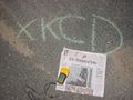
The marker on the pavement
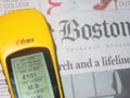
The GPS
