Difference between revisions of "2009-02-07 45 -108"
From Geohashing
imported>Benjw m (+map +cats) |
m (per Renaming Proposal) |
||
| (One intermediate revision by one other user not shown) | |||
| Line 16: | Line 16: | ||
</gallery> | </gallery> | ||
| − | {{ | + | {{Graticule unlocked |
| latitude = 45 | | latitude = 45 | ||
| Line 28: | Line 28: | ||
[[Category:Expeditions with photos]] | [[Category:Expeditions with photos]] | ||
[[Category:Coordinates reached]] | [[Category:Coordinates reached]] | ||
| + | {{location|US|MT|YS}} | ||
Latest revision as of 06:38, 20 March 2024
| Sat 7 Feb 2009 in Billings: 45.9706489, -108.2761965 geohashing.info google osm bing/os kml crox |
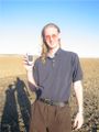
Successful Virgin Geohash. A field about 10mi N of Huntley, 3 mi NE of Shepherd. Gretchen and David left Rocky about 3pm, and after about 10 minutes through a muddy field were at the hash point at exactly 4 pm. Yay mud. 50 degrees, clear sky, gorgeous day. Snow, but not freezing.
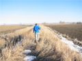
Gretchen leading the way across a high berm canal separating two fields.
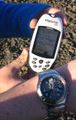
There was a slight misunderstanding between coordinates- I gave Gretchen seconds of arc, but the GPS only went to minutes of arc. Thus, we were off by about 25 feet- which was still the same field.
With sundown at 5:30, 4 is getting kind of late.
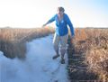
It was very muddy. Gretchen decided to take the "solid" snow route. Snow is never solid.


David Souther earned the Graticule Unlocked Achievement
|