Difference between revisions of "2008-12-22 36 -84"
imported>Applesandvodka |
m (per Renaming Proposal) |
||
| (9 intermediate revisions by 7 users not shown) | |||
| Line 8: | Line 8: | ||
__NOTOC__ | __NOTOC__ | ||
== Participants == | == Participants == | ||
| − | [[User:Applesandvodka]] | + | [[User:Applesandvodka|Applesandvodka]] |
== Plans == | == Plans == | ||
| Line 19: | Line 19: | ||
<gallery perrow="3"> | <gallery perrow="3"> | ||
| + | Image:Jacksboropoint.JPG | Yea. It was a rather exciting looking area. Lots of trees. | ||
Image:Northofapplesandvodkashash20081222.JPG | What a delightful camper they have! | Image:Northofapplesandvodkashash20081222.JPG | What a delightful camper they have! | ||
</gallery> | </gallery> | ||
| Line 27: | Line 28: | ||
[[Category:Coordinates reached]] | [[Category:Coordinates reached]] | ||
| − | {{ | + | {{Graticule unlocked | latitude = 36 | longitude = -84 | date = 2008-12-22 | name = Applesandvodka}} |
| + | {{location|US|TN|CM}} | ||
Latest revision as of 06:41, 20 March 2024
| Mon 22 Dec 2008 in 36,-84: 36.2986907, -84.2002318 geohashing.info google osm bing/os kml crox |
Participants
Plans
Well, I was planning on driving from Knoxville to Lexington that day. Upon waking, I wanted to see where the location for the day was...and lo and behold, it happened to be just 3 miles off of Interstate 75. Naturally, I decided that I had to go on it, so I printed off a map with a plot of the location, saved a satellite image of the area, and took along my camera. Unfortunately, I was unable to obtain a GPS, so I decided to take pictures and document the trip by taking random photographs of road signs and the site.
Expedition
Well, before I left, I had to take my car to the shop due to the fact that the cold weather had caused my hoses to contract, leading to a rather unsightly puddle of antifreeze underneath my car. After getting that fixed, I gathered my stuff and went on my way. 25 miles up the interstate, I found the nearest exit to the location in question. Unfortunately, I ended up reading the map wrong, and spent a small period of time driving along aimlessly on a tiny road in the middle of the mountains. Rather inconvenient, but after I turned around (and got stuck behind a truck going 25 miles per hour), I managed to find my way to US-25W, where I promptly turned left. About a mile down the road, I found Ridge Road, where I turned right, and went for awhile. After ascending a very long gravel driveway on a rather steep hill, I managed to get within view of the coordinates...which, according to the satellite image, were right next to a bunch of trees. So I snapped a picture in all four directions and departed, returning to my trip to Lexington.
Photos
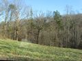
Yea. It was a rather exciting looking area. Lots of trees.
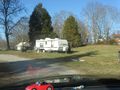
What a delightful camper they have!


Applesandvodka earned the Graticule Unlocked Achievement
|