Difference between revisions of "2013-03-01 48 -3"
imported>Yggodin ([live] Here am I. My first geohash ever. Not much stuff around, but I thought about taking the cobra flash out and using it to startle the drivers on the road nearby. Naaah, just kidding ;-) The Google Map picture is not very accurate, though. Much m...) |
m (per Renaming Proposal) |
||
| (10 intermediate revisions by 3 users not shown) | |||
| Line 15: | Line 15: | ||
}} | }} | ||
| − | + | ||
__NOTOC__ | __NOTOC__ | ||
== Location == | == Location == | ||
| − | + | ||
| + | In (almost) the small town of Begard. | ||
== Participants == | == Participants == | ||
| − | + | ||
| − | + | * [[User:Yggodin|Yggodin]] | |
== Plans == | == Plans == | ||
| − | + | ||
| + | Originally, planned to go during my lunch break... But laziness came and visited me, so I planned this again for the evening. | ||
== Expedition == | == Expedition == | ||
| − | |||
| + | Here am I. My first geohash expedition ever. Quite an easy one to begin with, not far from where I live, and easily accessible by car. Not much stuff around, but I thought about taking the cobra flash out and using it to startle the drivers on the road nearby. | ||
| + | |||
| + | Naaah, just kidding ;-) Or am I ? Oups, a police car. | ||
| + | |||
| + | Nah, really, I didn't do it, I wouldn't like someone else to do this to me, just for fun. | ||
| + | |||
| + | The Google Map picture is not very accurate, though. Much more buildings than expected :-) Oh, a vet office (almost) right on the spot. And what is that? A fence? | ||
| − | + | Is there a sign somewhere? Nope. Is there something/someone inside? Maybe a swarm of giant, six-legged red spiders? Or a velociraptor? Nope? OK, good to go! | |
| − | + | Less than fifty meters later, here I was, right on the spot. But no sign of anyone before me. And I forgot to bring a nice sign... Oh, let's drop the backback, put the phone/GPS on it and take a picture. Done and done ! | |
| − | + | But damn, it's cold... Time to go back to the car, before I transform into an ice cube :-P -- [[User:Yggodin|Yggodin]] ([[User talk:Yggodin|talk]]) [http://www.openstreetmap.org/?lat=48.62002563&lon=-3.29564095&zoom=16&layers=B000FTF @48.6200,-3.2956] 18:44, 1 March 2013 (CET) | |
| − | |||
== Tracklog == | == Tracklog == | ||
<!-- if your GPS device keeps a log, you may post a link here --> | <!-- if your GPS device keeps a log, you may post a link here --> | ||
== Photos == | == Photos == | ||
| − | + | ||
| − | |||
| − | |||
<gallery perrow="5"> | <gallery perrow="5"> | ||
| + | Image:2013_03_01_48_-3_spotted.JPG|Right on the spot! | ||
| + | Image:2013_03_01_48_-3_oneside.JPG|One side... Buildings, roads, and stuff... And the vet office ;) | ||
| + | Image:2013_03_01_48_-3_otherside.JPG|The other side: trees everywhere! | ||
</gallery> | </gallery> | ||
== Achievements == | == Achievements == | ||
{{#vardefine:ribbonwidth|800px}} | {{#vardefine:ribbonwidth|800px}} | ||
| − | + | {{Graticule unlocked | |
| + | | latitude = 48 | ||
| + | | longitude = -3 | ||
| + | | date = 2013-03-01 | ||
| + | | name = [[User:Yggodin|Yggodin]] | ||
| + | }} | ||
| + | {{Land geohash | ||
| + | | latitude = 48 | ||
| + | | longitude = -3 | ||
| + | | date = 2013-03-01 | ||
| + | | name = [[User:Yggodin|Yggodin]] | ||
| + | }} | ||
| − | |||
| − | |||
| − | |||
| − | |||
| − | |||
| − | |||
| − | |||
| − | |||
| − | |||
| − | |||
| − | |||
| − | |||
[[Category:Expeditions with photos]] | [[Category:Expeditions with photos]] | ||
| − | |||
| − | |||
| − | |||
| − | |||
| − | |||
[[Category:Coordinates reached]] | [[Category:Coordinates reached]] | ||
| − | + | [[Category:Expeditions]] | |
| − | + | {{location|FR|22}} | |
| − | |||
| − | |||
| − | |||
| − | |||
| − | |||
| − | |||
| − | |||
| − | |||
| − | |||
| − | [[Category: | ||
| − | |||
| − | |||
| − | |||
| − | |||
| − | |||
Latest revision as of 06:43, 20 March 2024
| Fri 1 Mar 2013 in 48,-3: 48.6200128, -3.2956441 geohashing.info google osm bing/os kml crox |
Location
In (almost) the small town of Begard.
Participants
Plans
Originally, planned to go during my lunch break... But laziness came and visited me, so I planned this again for the evening.
Expedition
Here am I. My first geohash expedition ever. Quite an easy one to begin with, not far from where I live, and easily accessible by car. Not much stuff around, but I thought about taking the cobra flash out and using it to startle the drivers on the road nearby.
Naaah, just kidding ;-) Or am I ? Oups, a police car.
Nah, really, I didn't do it, I wouldn't like someone else to do this to me, just for fun.
The Google Map picture is not very accurate, though. Much more buildings than expected :-) Oh, a vet office (almost) right on the spot. And what is that? A fence?
Is there a sign somewhere? Nope. Is there something/someone inside? Maybe a swarm of giant, six-legged red spiders? Or a velociraptor? Nope? OK, good to go!
Less than fifty meters later, here I was, right on the spot. But no sign of anyone before me. And I forgot to bring a nice sign... Oh, let's drop the backback, put the phone/GPS on it and take a picture. Done and done !
But damn, it's cold... Time to go back to the car, before I transform into an ice cube :-P -- Yggodin (talk) @48.6200,-3.2956 18:44, 1 March 2013 (CET)
Tracklog
Photos
Right on the spot!
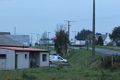
One side... Buildings, roads, and stuff... And the vet office ;)
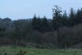
The other side: trees everywhere!


Achievements
Yggodin earned the Graticule Unlocked Achievement
|
Yggodin earned the Land geohash achievement
|