Difference between revisions of "2008-06-08 38 -78"
imported>Phyzome (I have a recevier now) |
m (per Renaming Proposal) |
||
| (9 intermediate revisions by 3 users not shown) | |||
| Line 6: | Line 6: | ||
}} | }} | ||
| + | == Planning == | ||
| + | [[Image:2008-06-08 38 -78 satellite map.jpg|200|thumb|left|Satellite view]] | ||
Location is just off of a power cut that is reachable by Mountain Rd near Thelma, VA. East of Charlottesville. | Location is just off of a power cut that is reachable by Mountain Rd near Thelma, VA. East of Charlottesville. | ||
[[User:Phyzome|Phyzome]] should be able to make it now that he has a handheld GPS receiver. Anyone want to carpool? | [[User:Phyzome|Phyzome]] should be able to make it now that he has a handheld GPS receiver. Anyone want to carpool? | ||
| + | |||
| + | <br clear="left" /> | ||
| + | == Results == | ||
| + | |||
| + | === Phyzome === | ||
| + | '''Success''' by [[User:Phyzome|Phyzome]]! It was not in fact a power cut, but some sort of long, occasionally mown field. Could not determine its purpose. (Maybe there were buried utilities?) | ||
| + | |||
| + | I came to the end of the tractor ruts. The field dipped down into a marshy area where some deer were grazing obliviously. I noticed a large number of shotgun shell casings where I was standing. A trail led off to the left, into the woods. I followed it, since the geohash was roughly that direction. | ||
| + | |||
| + | About 30 meters into the woods there were a few hunting stands. I cut north towards the hash, and found a sign reading "jump-shoot mallards" incongruously placed in the middle of a patch of ferns. (I'm starting to think the place was some sort of hunting practice area.) I then reached marsh. | ||
| + | |||
| + | Cutting west by northwest, I entered a scrubby area that appeared to have been clear-cut several years ago. Clear view of the sky for GPS, but the sun was beating down on me (did I mention it was 35C/95F?) and the horseflies were closing in. Big 'uns. Also, it was quite difficult to push through the small oaks and numerous briars. | ||
| + | |||
| + | After 30-50 meters of that, I finally reached the hash! The GPS wandered a bit, but I was within a few meters. \o/ | ||
| + | |||
| + | {{land geohash | ||
| + | | name = [[User:Phyzome|Phyzome]] | ||
| + | | date = 2008-06-08 | ||
| + | | latitude = 38 | ||
| + | | longitude = -78 | ||
| + | | image = 2008-06-08 38 -78 gps evidence.JPG | ||
| + | }} | ||
| + | |||
| + | {{Graticule unlocked | ||
| + | | latitude = 38 | ||
| + | | longitude = -78 | ||
| + | | date = 2008-06-08 | ||
| + | | name = [[User:Phyzome|Phyzome]] | ||
| + | | image = 2008-06-08 38 -78 gps evidence.JPG | ||
| + | }} | ||
| + | |||
| + | {{Velociraptor geohash | ||
| + | | latitude = 38 | ||
| + | | longitude = -78 | ||
| + | | date = 2008-06-08 | ||
| + | | name = [[User:Phyzome|Phyzome]] | ||
| + | }} | ||
| + | |||
| + | <gallery> | ||
| + | Image:2008-06-08 38 -78 straightaway.jpg|Looks easy enough... | ||
| + | Image:2008-06-08 38 -78 jump shoot mallards.JPG|I have no idea | ||
| + | Image:2008-06-08 38 -78 marsh.JPG|Marsh that I had to route around | ||
| + | Image:2008-06-08 38 -78 gps evidence.JPG|Finally! | ||
| + | </gallery> | ||
[[Category:Expeditions]] | [[Category:Expeditions]] | ||
| − | [[Category:Expeditions | + | [[Category:Expeditions with photos]] |
| + | [[Category:Coordinates reached]] | ||
| + | {{location|US|VA|LI}} | ||
Latest revision as of 07:41, 20 March 2024
| Sun 8 Jun 2008 in 38,-78: 38.0475817, -78.2309159 geohashing.info google osm bing/os kml crox |
Planning

Location is just off of a power cut that is reachable by Mountain Rd near Thelma, VA. East of Charlottesville.
Phyzome should be able to make it now that he has a handheld GPS receiver. Anyone want to carpool?
Results
Phyzome
Success by Phyzome! It was not in fact a power cut, but some sort of long, occasionally mown field. Could not determine its purpose. (Maybe there were buried utilities?)
I came to the end of the tractor ruts. The field dipped down into a marshy area where some deer were grazing obliviously. I noticed a large number of shotgun shell casings where I was standing. A trail led off to the left, into the woods. I followed it, since the geohash was roughly that direction.
About 30 meters into the woods there were a few hunting stands. I cut north towards the hash, and found a sign reading "jump-shoot mallards" incongruously placed in the middle of a patch of ferns. (I'm starting to think the place was some sort of hunting practice area.) I then reached marsh.
Cutting west by northwest, I entered a scrubby area that appeared to have been clear-cut several years ago. Clear view of the sky for GPS, but the sun was beating down on me (did I mention it was 35C/95F?) and the horseflies were closing in. Big 'uns. Also, it was quite difficult to push through the small oaks and numerous briars.
After 30-50 meters of that, I finally reached the hash! The GPS wandered a bit, but I was within a few meters. \o/
Phyzome earned the Land geohash achievement
|
Phyzome earned the Graticule Unlocked Achievement
|
Phyzome earned the Velociraptor Geohash Achievement
|
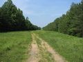
Looks easy enough...
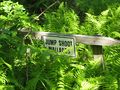
I have no idea
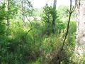
Marsh that I had to route around
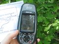
Finally!


