Difference between revisions of "2010-12-16 50 11"
imported>Mampfred (Created page with '{{subst:Expedition |lat = latitude of graticule |lon = longitude of graticule |date = date of expedition, in YYYY-MM-DD format }}') |
m (per Renaming Proposal) |
||
| (5 intermediate revisions by 2 users not shown) | |||
| Line 1: | Line 1: | ||
| − | |||
| − | |||
| − | |||
| − | |||
| − | |||
| − | |||
| − | |||
| − | |||
| − | |||
| − | |||
{{meetup graticule | {{meetup graticule | ||
| − | | lat= | + | | lat=50 |
| − | | lon= | + | | lon=11 |
| − | | date= | + | | date=2010-12-16 |
}} | }} | ||
| − | |||
__NOTOC__ | __NOTOC__ | ||
== Location == | == Location == | ||
| − | + | Behind the A4 south or Erfurt in a field. | |
== Participants == | == Participants == | ||
| − | + | *[[User:Mampfred|Mampfred]] | |
| + | *[[User:Rincewind|Rincewind]] | ||
| + | *[[User:LadyBB|LadyBB]] | ||
== Plans == | == Plans == | ||
| − | + | Get there in the evening despite the snow and wind. | |
== Expedition == | == Expedition == | ||
| − | + | Found the area all right but couldn't find a spot to park the car along the main road. So we tried a different approach through a nearby little village which seemed to be only a small detour on our way. Made it up to about 1.5km apart from the hash by car. | |
| + | |||
| + | It was already dark and the thermometer showed about -5°C (with lots of wind so it felt more like -15°C) but we started walking toward the hash and almost immediately hit a solid snow cover of about about 30-40cm which was all we could see all the way to the hash. Tried a 100m sprint through the snow but decided that there was no way we could go on all the way to the hash with the shoes we had without freezing something we might still need the following day. | ||
| + | |||
| + | So - sadly - we snapped a group photo and turned around to give up :( | ||
== Tracklog == | == Tracklog == | ||
| − | + | TODO | |
== Photos == | == Photos == | ||
| − | |||
| − | |||
| − | |||
<gallery perrow="5"> | <gallery perrow="5"> | ||
| + | Image:2010-12-16_50_11_close.jpg | Ah, nearly made it into the photo ... | ||
| + | Image:2010-12-16_50_11_hasher.jpg |... yep, that's better. Hashers united. Too cold to grin (unfortunately we didn't capture the heaps of snow around us). | ||
</gallery> | </gallery> | ||
== Achievements == | == Achievements == | ||
{{#vardefine:ribbonwidth|800px}} | {{#vardefine:ribbonwidth|800px}} | ||
| − | + | {{Done with nature | |
| + | | latitude = 50 | ||
| + | | longitude = 11 | ||
| + | | date = 2010-12-16 | ||
| + | | name = Mampfred, Rincewind and LadyBB | ||
| + | }} | ||
| − | |||
| − | |||
| − | |||
| − | |||
| − | |||
| − | |||
| − | |||
| − | |||
| − | |||
| − | |||
| − | |||
[[Category:Expeditions]] | [[Category:Expeditions]] | ||
| − | |||
[[Category:Expeditions with photos]] | [[Category:Expeditions with photos]] | ||
| − | |||
| − | |||
| − | |||
| − | |||
| − | |||
| − | |||
| − | |||
| − | |||
| − | |||
[[Category:Coordinates not reached]] | [[Category:Coordinates not reached]] | ||
| − | + | [[Category:Not reached - Mother Nature]] | |
| − | [[Category:Not reached - Mother Nature]] | + | {{location|DE|TH|IK}} |
| − | |||
| − | |||
| − | |||
| − | |||
Latest revision as of 14:39, 2 April 2024
| Thu 16 Dec 2010 in 50,11: 50.8975937, 11.0819564 geohashing.info google osm bing/os kml crox |
Location
Behind the A4 south or Erfurt in a field.
Participants
Plans
Get there in the evening despite the snow and wind.
Expedition
Found the area all right but couldn't find a spot to park the car along the main road. So we tried a different approach through a nearby little village which seemed to be only a small detour on our way. Made it up to about 1.5km apart from the hash by car.
It was already dark and the thermometer showed about -5°C (with lots of wind so it felt more like -15°C) but we started walking toward the hash and almost immediately hit a solid snow cover of about about 30-40cm which was all we could see all the way to the hash. Tried a 100m sprint through the snow but decided that there was no way we could go on all the way to the hash with the shoes we had without freezing something we might still need the following day.
So - sadly - we snapped a group photo and turned around to give up :(
Tracklog
TODO
Photos
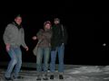
Ah, nearly made it into the photo ...
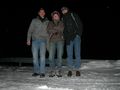
... yep, that's better. Hashers united. Too cold to grin (unfortunately we didn't capture the heaps of snow around us).


Achievements
Mampfred, Rincewind and LadyBB earned the Done with Nature consolation prize
|