Difference between revisions of "2023-12-18 65 25"
(Created page with "{{subst:expedition}}") |
(had used a Swedish word by mistake) |
||
| (7 intermediate revisions by 2 users not shown) | |||
| Line 1: | Line 1: | ||
| − | + | {{meetup graticule | |
| − | |||
| − | |||
| − | |||
| − | |||
| − | |||
| − | |||
| − | |||
| − | |||
| lat={{#explode:{{SUBPAGENAME}}| |1}} | | lat={{#explode:{{SUBPAGENAME}}| |1}} | ||
| lon={{#explode:{{SUBPAGENAME}}| |2}} | | lon={{#explode:{{SUBPAGENAME}}| |2}} | ||
| date={{#explode:{{SUBPAGENAME}}| |0}} | | date={{#explode:{{SUBPAGENAME}}| |0}} | ||
| − | }} | + | }} |
== Location == | == Location == | ||
| − | + | In an urban park. Technically not in the centre district, but practically right in the city centre of Oulu. | |
== Participants == | == Participants == | ||
| − | + | * [[User:Kripakko|Kripakko]] | |
| − | |||
| − | == | + | == Expedition == |
| − | + | I left from work at about quarter past five and cycled to the city centre. | |
| + | The hashpoint was very easy to reach, being located between a parking area and the Kaupunginoja stream. | ||
| + | I had found out beforehand that there should be a couple of pubs visible from the point, | ||
| + | and indeed I could see Letkunpuiston Helmi, the nearest open one, across the park. | ||
| + | It is located next to Kantakrouvi, a much bigger place which unfortunately is open only on Friday and Saturday. | ||
| + | I went there and had a glass of domestic New England IPA. | ||
| + | Thereafter, I cycled to a grocery store and finally home. | ||
| − | + | I did not record the temperature, but I could tell by the consistency of snow that it was slightly above freezing. | |
| − | |||
== Tracklog == | == Tracklog == | ||
| − | + | {{tracklog|2023-12-18 65 25 tracklog.gpx}} | |
== Photos == | == Photos == | ||
| − | < | + | <gallery perrow="6"> |
| − | Image: | + | Image:2023-12-18_65_25_01-bicycle.jpg | The bicycle parked at the hashpoint. |
| − | -- | + | Image:2023-12-18_65_25_02-gpsr1.jpg | Proof of location. |
| − | + | Image:2023-12-18_65_25_03-gpsr2.jpg | Proof of date and time. | |
| + | Image:2023-12-18_65_25_04-selfie.jpg | Stupid Grin™ | ||
| + | Image:2023-12-18_65_25_05-pointing.jpg | Pointing towards the Letkunpuiston Helmi pub which is there behind the spruce branches. | ||
| + | Image:2023-12-18_65_25_06-pub.jpg | Having a beer in the pub. | ||
</gallery> | </gallery> | ||
== Achievements == | == Achievements == | ||
| − | {{# | + | {{land geohash |
| − | + | | name = [[User:Kripakko|Kripakko]] | |
| + | | latitude = {{#explode:{{SUBPAGENAME}}| |1}} | longitude = {{#explode:{{SUBPAGENAME}}| |2}} | date = {{#explode:{{SUBPAGENAME}}| |0}} | ||
| + | }} | ||
| + | {{bicycle geohash | ||
| + | | name = [[User:Kripakko|Kripakko]] | ||
| + | | latitude = {{#explode:{{SUBPAGENAME}}| |1}} | longitude = {{#explode:{{SUBPAGENAME}}| |2}} | date = {{#explode:{{SUBPAGENAME}}| |0}} | ||
| + | }} | ||
| + | {{pub geohash | ||
| + | | name = [[User:Kripakko|Kripakko]] | ||
| + | | latitude = {{#explode:{{SUBPAGENAME}}| |1}} | longitude = {{#explode:{{SUBPAGENAME}}| |2}} | date = {{#explode:{{SUBPAGENAME}}| |0}} | ||
| + | }} | ||
| + | {{consecutive geohash 3 | ||
| + | | name = [[User:Kripakko|Kripakko]] | ||
| + | | latitude = 63 | longitude = 26 | date = 2023-12-17 | ||
| + | | hashcount = 2 | ||
| + | | daycount = 2 | ||
| + | }} | ||
__NOTOC__ | __NOTOC__ | ||
| − | |||
| − | |||
| − | |||
| − | |||
| − | |||
| − | |||
| − | |||
| − | |||
| − | |||
| − | |||
| − | |||
| − | |||
| − | |||
[[Category:Expeditions]] | [[Category:Expeditions]] | ||
| − | |||
[[Category:Expeditions with photos]] | [[Category:Expeditions with photos]] | ||
| − | |||
| − | |||
| − | |||
| − | |||
| − | |||
[[Category:Coordinates reached]] | [[Category:Coordinates reached]] | ||
| − | + | {{location|FI|14}} | |
| − | |||
| − | |||
| − | |||
| − | |||
| − | |||
| − | |||
| − | |||
| − | |||
| − | |||
| − | |||
| − | |||
| − | |||
| − | |||
| − | |||
| − | |||
| − | |||
| − | |||
Revision as of 20:48, 5 May 2024
| Mon 18 Dec 2023 in 65,25: 65.0109859, 25.4752137 geohashing.info google osm bing/os kml crox |
Location
In an urban park. Technically not in the centre district, but practically right in the city centre of Oulu.
Participants
Expedition
I left from work at about quarter past five and cycled to the city centre. The hashpoint was very easy to reach, being located between a parking area and the Kaupunginoja stream. I had found out beforehand that there should be a couple of pubs visible from the point, and indeed I could see Letkunpuiston Helmi, the nearest open one, across the park. It is located next to Kantakrouvi, a much bigger place which unfortunately is open only on Friday and Saturday. I went there and had a glass of domestic New England IPA. Thereafter, I cycled to a grocery store and finally home.
I did not record the temperature, but I could tell by the consistency of snow that it was slightly above freezing.
Tracklog
Photos
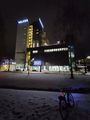
The bicycle parked at the hashpoint.
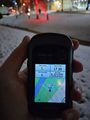
Proof of location.
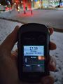
Proof of date and time.
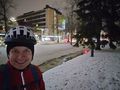
Stupid Grin™
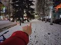
Pointing towards the Letkunpuiston Helmi pub which is there behind the spruce branches.
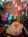
Having a beer in the pub.


Achievements
Kripakko earned the Land geohash achievement
|
Kripakko earned the Bicycle geohash achievement
|
Kripakko earned the Pub Geohash Achievement
|
Kripakko earned the Consecutive geohash achievement
|