Difference between revisions of "2024-05-08 30 -97"
Sporksmith (talk | contribs) (Created page with "{{subst:Expedition}}") |
Sporksmith (talk | contribs) (→Achievements) |
||
| (10 intermediate revisions by the same user not shown) | |||
| Line 13: | Line 13: | ||
}}<!-- edit as necessary --> | }}<!-- edit as necessary --> | ||
== Location == | == Location == | ||
| − | + | ||
| + | Just off of the Northeast Metro Park walk/bike trail, in Pflugerville. | ||
== Participants == | == Participants == | ||
| − | + | [[User:Sporksmith|Sporksmith]] ([[User talk:Sporksmith|talk]]) | |
| − | |||
== Plans == | == Plans == | ||
| Line 23: | Line 23: | ||
== Expedition == | == Expedition == | ||
| − | + | ||
| + | I normally don't like driving a car for geohashing purposes, but the hash point was simultaneously tantalizingly accessible, but still a bit far to bike to on a work day. I ended up taking the car out for errands anyway, so decided to take a detour to hit the hash point. | ||
| + | |||
| + | The drive was uneventful, and I parked in a lot about a quarter mile North of the hashpoint. I had planned on riding my ultimate wheel (seatless unicycle) from there to the hash point, but I'd forgotten to check the tire pressure before leaving home and it was pretty flat. The drive had also taken longer than anticipated, so I decided to just get on with it on foot. | ||
| + | |||
| + | I initially determined that I was going to have to scramble down an incline to a storm drain to reach the point. I did so, only to find that I'd misjudged, and that it was actually back up at the "trail level" just a little further down. Worse, I had apparently stepped on a fire ant hill on the way down and been stung a couple times. The last time I was stung by fire ants I ended up breaking out in hives and eventually anaphylaxis, requiring a shot to get things under control. I'd been prescribed an epi pen, but it was back at home. Last time the symptoms had taken an hour or two to develop so I figured I had some time, but now really needed to get moving. | ||
| + | |||
| + | I clambered back up, located the actual hashpoint, hastily set up my phone to record some video, and briefly juggled for the circus hash achievement. | ||
| + | |||
| + | I hoofed it back to the car, noticing a warning sign about snakes. At least I didn't encounter any of those! I stopped at a gas station to pick up and take some benadryl to hopefully stave off the allergic reaction. The drive home had a lot of traffic but was otherwise uneventful. | ||
| + | |||
| + | Home safe now with epi pen on standby. Starting to get some hives, but no breathing trouble so far. I'm not too worried; at the first sign of breathing problems I'll take the epi pen and have my partner drive me to urgent care. | ||
== Tracklog == | == Tracklog == | ||
| − | + | {{tracklog | 2024-05-08_30_-97-sporksmith.gpx}} | |
== Photos == | == Photos == | ||
| Line 33: | Line 44: | ||
--> | --> | ||
<gallery perrow="5"> | <gallery perrow="5"> | ||
| + | Image:2024-05-08_30_-97-sporksmith-embankment.jpg | Embankment I unnecessarily scrambled down | ||
| + | Image:2024-05-08_30_-97-sporksmith-fire-ants.jpg | Fire ant hill I managed to step on | ||
| + | Image:2024-05-08_30_-97-sporksmith-reached.png | Coordinates reached | ||
| + | Image:2024-05-08_30_-97-sporksmith-clubs.jpg | Club juggling | ||
</gallery> | </gallery> | ||
== Achievements == | == Achievements == | ||
{{#vardefine:ribbonwidth|100%}} | {{#vardefine:ribbonwidth|100%}} | ||
| − | + | ||
| + | {{land geohash | ||
| + | | latitude = 30 | ||
| + | | longitude = -97 | ||
| + | | date = 2024-05-08 | ||
| + | | name = sporksmith | ||
| + | }} | ||
| + | {{Circus_geohash | ||
| + | | latitude = 30 | ||
| + | | longitude = -97 | ||
| + | | date = 2024-05-08 | ||
| + | | name = sporksmith | ||
| + | | performance = juggling | ||
| + | }} | ||
__NOTOC__ | __NOTOC__ | ||
| − | |||
| − | |||
| − | |||
| − | |||
| − | |||
| − | |||
| − | |||
| − | |||
| − | |||
[[Category:Expeditions]] | [[Category:Expeditions]] | ||
| − | |||
[[Category:Expeditions with photos]] | [[Category:Expeditions with photos]] | ||
| − | |||
| − | |||
| − | |||
| − | |||
[[Category:Coordinates reached]] | [[Category:Coordinates reached]] | ||
| − | + | {{location|US|TX|WM}} | |
| − | |||
| − | |||
| − | |||
| − | |||
| − | |||
| − | |||
| − | |||
| − | |||
| − | |||
| − | |||
| − | |||
| − | |||
| − | |||
Revision as of 00:13, 9 May 2024
| Wed 8 May 2024 in 30,-97: 30.4130363, -97.5996918 geohashing.info google osm bing/os kml crox |
Location
Just off of the Northeast Metro Park walk/bike trail, in Pflugerville.
Participants
Plans
Expedition
I normally don't like driving a car for geohashing purposes, but the hash point was simultaneously tantalizingly accessible, but still a bit far to bike to on a work day. I ended up taking the car out for errands anyway, so decided to take a detour to hit the hash point.
The drive was uneventful, and I parked in a lot about a quarter mile North of the hashpoint. I had planned on riding my ultimate wheel (seatless unicycle) from there to the hash point, but I'd forgotten to check the tire pressure before leaving home and it was pretty flat. The drive had also taken longer than anticipated, so I decided to just get on with it on foot.
I initially determined that I was going to have to scramble down an incline to a storm drain to reach the point. I did so, only to find that I'd misjudged, and that it was actually back up at the "trail level" just a little further down. Worse, I had apparently stepped on a fire ant hill on the way down and been stung a couple times. The last time I was stung by fire ants I ended up breaking out in hives and eventually anaphylaxis, requiring a shot to get things under control. I'd been prescribed an epi pen, but it was back at home. Last time the symptoms had taken an hour or two to develop so I figured I had some time, but now really needed to get moving.
I clambered back up, located the actual hashpoint, hastily set up my phone to record some video, and briefly juggled for the circus hash achievement.
I hoofed it back to the car, noticing a warning sign about snakes. At least I didn't encounter any of those! I stopped at a gas station to pick up and take some benadryl to hopefully stave off the allergic reaction. The drive home had a lot of traffic but was otherwise uneventful.
Home safe now with epi pen on standby. Starting to get some hives, but no breathing trouble so far. I'm not too worried; at the first sign of breathing problems I'll take the epi pen and have my partner drive me to urgent care.
Tracklog
Photos
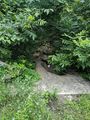
Embankment I unnecessarily scrambled down
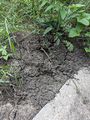
Fire ant hill I managed to step on

Coordinates reached
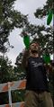
Club juggling


Achievements
sporksmith earned the Land geohash achievement
|
sporksmith earned the Circus Geohash Achievement
|