Difference between revisions of "1998-01-04 53 9"
m (Categorized as retro) |
m (subst-ing) |
||
| (25 intermediate revisions by 3 users not shown) | |||
| Line 1: | Line 1: | ||
| − | + | [[Image:1998-01-04 53 9 - Photo of Elbe river to the east.jpg|thumb|left]] | |
| − | + | {{meetup graticule | |
| − | [[Image: | ||
| − | |||
| − | |||
| − | |||
| − | |||
| − | |||
| − | |||
| lat=53 | | lat=53 | ||
| lon=9 | | lon=9 | ||
| date=1998-01-04 | | date=1998-01-04 | ||
| retro=1 | | retro=1 | ||
| − | }} | + | }} |
== Location == | == Location == | ||
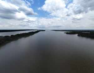
| − | < | + | A little bit south of the shore of an island in the middle of the [[wikipedia:Elbe|Elbe river]].<br> |
| + | The city of [[wikipedia:Wedel|Wedel]] ([[wikipedia:Schleswig-Holstein|Schleswig-Holstein]]) lies on the northern river shore and the JVA Hahnöfersand <small>(JVA = Justizvollzugsanstalt = correctional facility)</small> of Jork ([[wikipedia:Lower Saxony|Lower Saxony]]) on the southern one. | ||
| + | |||
== Participants == | == Participants == | ||
| − | + | *[[User:Rsge|Rsge]] ([[User talk:Rsge|talk]]) | |
| − | |||
== Plans == | == Plans == | ||
| − | < | + | === Rsge === |
| + | I wanted to start geohashing for a while now and what better way to start than to get to my Origin geohash first.<br> | ||
| + | Looking it up <small>(which I did via the [https://geohashing.site/geohashing/Implementations#Shotgun Shotgun tool] because I didn't realize I could go that far back on [https://geohashing.info geohashing.info] at first)</small>, I found it to be in the middle of the water. But luckily I own a drone and it shouldn't be so far off the coast of Wedel <small>(which would be much easier for me to get to, living in Schleswig-Holstein, than the other shore would be - also, with a prison being on the other side)</small>, that the remote wouldn't reach - so I'd make it a Geohash by proxy.<br> | ||
| + | I planned going on Fr. the 30th of June, as I wanted to have a bit of a special date but wouldn't have time on the 1st of July. Then I got the idea to go a bit later, on the 4th of July <small>(today as of writing this)</small> to reach it exactly 25½ years after my birthday, but the weather was forecast to be rainy, which my drone wouldn't like, so Friday it was.<br> | ||
| + | I planned to go by car to somewhere near the beach in Wedel, as public transport from my home town to Wedel isn't great and I didn't have the time to go all the way by bike, as I had other appointments later in the day. | ||
| − | == Expedition == | + | == Retro Expedition == |
| − | < | + | === Rsge (2023-06-30) === |
| − | + | After I came home from work and had breakfast, I packed my drone and took one last look at the weather forecast. My little brother was using my usual car, so I needed to use my mother's. I got in and started the GPS to the Wedel beach. The drone I had charged while eating, so it's batteries were full - but I realized my phone <small>(which is needed for drone remote viewing)</small> wasn't. Luckily, I put chargers in the family cars, this one included, so I plugged in my phone and started to drive.<br> | |
| − | + | Just a few meters from home I realized my phone wasn't charging - the cable was broken - so I looped around and got another cable. Then, on the way again, I mixed up the brake with the clutch, as I'm not used to driving automatic. Then I had to wait ages at the first crossroads, just missing a gap. I briefly considered aborting the whole thing, as it already seemed a bit cursed - but I'm not the superstitious type, so I kept going.<br> | |
| − | < | + | I got to near the beach without further problems and got the last parking spot just a few meters away from the pedestrian walkway to the beach. Going down the walkway I realized it was high on a hillside with stairs leading down to the beach area - and I could just start my drone from there, even having higher range because of being higher up. There were some benches to unpack my drone on, so I started getting it ready. A few retirees were sitting not that far away, but they didn't seem to mind and in fact seemed mildly interested as I connected everything up and started the drone.<br> |
| + | I didn't know how to set waypoints by exact coordinates in my drone's app <small>(DJI Fly)</small> and in fact couldn't even get coordinate numbers, as I was still using [https://geohashing.site/geohashing/Implementations#Shotgun Shotgun], which as far as I'm aware can't show coordinates on mobile. So I switched to satellite images on Shotgun and DJI Fly and compared location as best I could. Luckily, there was a tidal inlet almost exactly at the location, so it wasn't super inaccurate <small>I hope</small>.<br> | ||
| + | It was a nice day, not too warm, not too cold, clear sky and very little in regards to wind, so the flight went over without any problems. I took a few photos with the drone and a few screenshots of the path and started packing again. While packing, a guy came over and asked me about my drone, so we had a nice short chat about drones, their use and the legal restrictions placed on flying them.<br> | ||
| + | I got back to the car and drove home without any problems. | ||
| + | <small> | ||
| + | * For those interested: In Germany, ''all'' drones which are not explicitly classified as toys need the following: | ||
| + | ** A Haftpflichtversicherung (liability insurance) with explicit inclusion of damage done by drone. | ||
| + | ** An e-ID from the LBA (Luftfahrtbundesamt, German federal aviation administration), which is free and just needs insurance and ID confirmation. | ||
| + | ** A metallic sign on the drone with at least this e-ID. Name, phone number, etc. are optional. | ||
| + | * The max flight height is 120 m (ca. 400 ft). | ||
| + | * If your drone weighs less than 250 g (ca. 8.8 oz), nothing further is needed. For higher weights you need additional licenses and registrations. | ||
| + | * [https://bmdv.bund.de/SharedDocs/DE/Anlage/LF/EN-drones-rules-in-the-eu.pdf?__blob=publicationFile Further info]. | ||
| + | </small> | ||
== Photos == | == Photos == | ||
| − | < | + | <gallery mode="packed" heights="140px"> |
| − | Image: | + | Image:1998-01-04 53 9 - Screenshot Shotgun.png | Screenshot of the map in Shotgun. |
| − | -- | + | Image:1998-01-04 53 9 - Screenshot Satellite DDG Map.png | Screenshot of the satellite map from DDG. |
| − | + | Image:1998-01-04 53 9 - Screenshot DJI Fly Drone at position.png | Screenshot from DJI Fly with the drone at the hash position. | |
| + | Image:1998-01-04 53 9 - Screenshot drone path.png | Screenshot of the drone's path in DJI Fly. | ||
| + | Image:1998-01-04 53 9 - Pano North.jpg | Panorama of the north of the hash. | ||
| + | Image:1998-01-04 53 9 - Photo of small harbour terminal.jpg | The small terminal to the north of the hash. | ||
| + | Image:1998-01-04 53 9 - Pano South.jpg | Panorama of the south of the hash. | ||
| + | Image:1998-01-04 53 9 - Photo of JVA peninsula.jpg | The JVA to the south of the hash. | ||
| + | Image:1998-01-04 53 9 - Photo of Elbe river to the east.jpg | The Elbe river to the east. | ||
| + | Image:1998-01-04 53 9 - Straight down.jpg | Straight-down look at the (rough) hash. | ||
| + | Image:1998-01-04 53 9 - Photo of pilot's position.jpg | Rsge's position from a bird's eye view with Wedel in the background. | ||
| + | Image:1998-01-04 53 9 - Rsge controlling the drone.jpg | Rsge piloting his drone. | ||
| + | Image:1998-01-04 53 9 - Pano from pilot's position.jpg | Panorama from Rsge's point of view, looking in the hash's direction. | ||
</gallery> | </gallery> | ||
== Achievements == | == Achievements == | ||
{{#vardefine:ribbonwidth|100%}} | {{#vardefine:ribbonwidth|100%}} | ||
| − | + | {{origin geohash | |
| + | | latitude = 53 | ||
| + | | longitude = 9 | ||
| + | | date = 1998-01-04 | ||
| + | | on = 2023-06-30 | ||
| + | | name = [[User:Rsge|Rsge]] | ||
| + | | image = 1998-01-04 53 9 - Photo of Elbe river to the east.jpg | ||
| + | }} | ||
__NOTOC__ | __NOTOC__ | ||
| − | + | [[Category:Retro meetup]] | |
| − | + | [[Category:Retro coordinates reached]] | |
| − | [[Category: | ||
| − | |||
| − | |||
| − | |||
| − | |||
| − | |||
| − | |||
| − | |||
| − | |||
| − | |||
| − | |||
| − | |||
| − | |||
| − | |||
[[Category:Expeditions with photos]] | [[Category:Expeditions with photos]] | ||
| − | + | {{location|DE|NI|STD}} | |
| − | |||
| − | |||
| − | |||
| − | |||
| − | |||
| − | |||
| − | |||
| − | |||
| − | |||
| − | |||
| − | |||
| − | |||
| − | |||
| − | |||
| − | |||
| − | |||
| − | |||
| − | |||
| − | |||
| − | |||
| − | |||
| − | |||
| − | |||
Latest revision as of 20:09, 24 May 2024
| Sun 4 Jan 1998 in 53,9: 53.5556849, 9.7156781 geohashing.info google osm bing/os kml crox |
Location
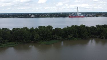
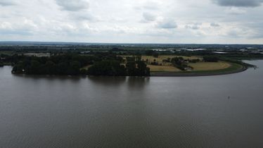
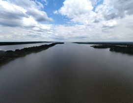
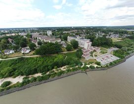
A little bit south of the shore of an island in the middle of the Elbe river.
The city of Wedel (Schleswig-Holstein) lies on the northern river shore and the JVA Hahnöfersand (JVA = Justizvollzugsanstalt = correctional facility) of Jork (Lower Saxony) on the southern one.
Participants
Plans
Rsge
I wanted to start geohashing for a while now and what better way to start than to get to my Origin geohash first.
Looking it up (which I did via the Shotgun tool because I didn't realize I could go that far back on geohashing.info at first), I found it to be in the middle of the water. But luckily I own a drone and it shouldn't be so far off the coast of Wedel (which would be much easier for me to get to, living in Schleswig-Holstein, than the other shore would be - also, with a prison being on the other side), that the remote wouldn't reach - so I'd make it a Geohash by proxy.
I planned going on Fr. the 30th of June, as I wanted to have a bit of a special date but wouldn't have time on the 1st of July. Then I got the idea to go a bit later, on the 4th of July (today as of writing this) to reach it exactly 25½ years after my birthday, but the weather was forecast to be rainy, which my drone wouldn't like, so Friday it was.
I planned to go by car to somewhere near the beach in Wedel, as public transport from my home town to Wedel isn't great and I didn't have the time to go all the way by bike, as I had other appointments later in the day.
Retro Expedition
Rsge (2023-06-30)
After I came home from work and had breakfast, I packed my drone and took one last look at the weather forecast. My little brother was using my usual car, so I needed to use my mother's. I got in and started the GPS to the Wedel beach. The drone I had charged while eating, so it's batteries were full - but I realized my phone (which is needed for drone remote viewing) wasn't. Luckily, I put chargers in the family cars, this one included, so I plugged in my phone and started to drive.
Just a few meters from home I realized my phone wasn't charging - the cable was broken - so I looped around and got another cable. Then, on the way again, I mixed up the brake with the clutch, as I'm not used to driving automatic. Then I had to wait ages at the first crossroads, just missing a gap. I briefly considered aborting the whole thing, as it already seemed a bit cursed - but I'm not the superstitious type, so I kept going.
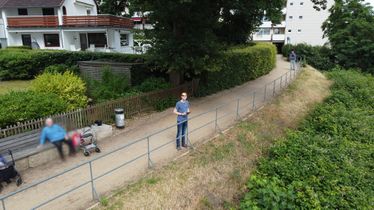
I got to near the beach without further problems and got the last parking spot just a few meters away from the pedestrian walkway to the beach. Going down the walkway I realized it was high on a hillside with stairs leading down to the beach area - and I could just start my drone from there, even having higher range because of being higher up. There were some benches to unpack my drone on, so I started getting it ready. A few retirees were sitting not that far away, but they didn't seem to mind and in fact seemed mildly interested as I connected everything up and started the drone.
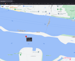
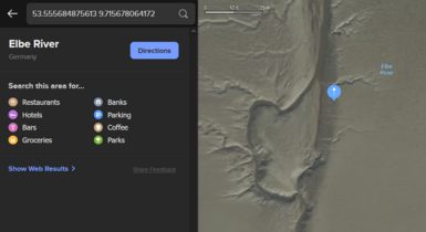
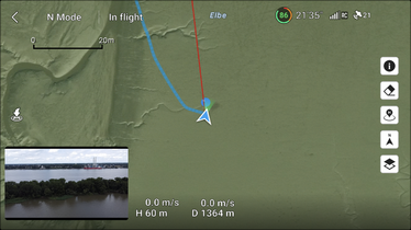
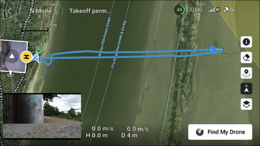
I didn't know how to set waypoints by exact coordinates in my drone's app (DJI Fly) and in fact couldn't even get coordinate numbers, as I was still using Shotgun, which as far as I'm aware can't show coordinates on mobile. So I switched to satellite images on Shotgun and DJI Fly and compared location as best I could. Luckily, there was a tidal inlet almost exactly at the location, so it wasn't super inaccurate I hope.
It was a nice day, not too warm, not too cold, clear sky and very little in regards to wind, so the flight went over without any problems. I took a few photos with the drone and a few screenshots of the path and started packing again. While packing, a guy came over and asked me about my drone, so we had a nice short chat about drones, their use and the legal restrictions placed on flying them.
I got back to the car and drove home without any problems.
- For those interested: In Germany, all drones which are not explicitly classified as toys need the following:
- A Haftpflichtversicherung (liability insurance) with explicit inclusion of damage done by drone.
- An e-ID from the LBA (Luftfahrtbundesamt, German federal aviation administration), which is free and just needs insurance and ID confirmation.
- A metallic sign on the drone with at least this e-ID. Name, phone number, etc. are optional.
- The max flight height is 120 m (ca. 400 ft).
- If your drone weighs less than 250 g (ca. 8.8 oz), nothing further is needed. For higher weights you need additional licenses and registrations.
- Further info.
Photos
Achievements
Rsge earned the Origin geohash achievement
|
