Difference between revisions of "2023-01-01 -41 172"
From Geohashing
m (subst-ing) |
|||
| (One intermediate revision by the same user not shown) | |||
| Line 2: | Line 2: | ||
{{meetup graticule | {{meetup graticule | ||
| − | | lat= | + | | lat=-41 |
| − | | lon= | + | | lon=172 |
| − | | date= | + | | date=2023-01-01 |
}}<!-- edit as necessary --> | }}<!-- edit as necessary --> | ||
== Location == | == Location == | ||
| Line 32: | Line 32: | ||
[[Category:Coordinates not reached]] | [[Category:Coordinates not reached]] | ||
[[Category:Not reached - No public access]] | [[Category:Not reached - No public access]] | ||
| + | {{location|NZ|TAS}} | ||
Latest revision as of 20:54, 24 May 2024
| Sun 1 Jan 2023 in -41,172: -41.3744586, 172.8470979 geohashing.info google osm bing/os kml crox |
Contents
Location
In a plantation near Tapawera
Participants
Plans
Plans: defy common sense and drive the tiny rental hatchback a long distance along a hilly, windy, dirt track through pine plantation before striding heroically to the point.
Expedition
Our first morning camping in Tapawera, I was surprised to see an upcoming geohash very close: only 6km away. It looked...infeasible.
I pondered:
- Plan A: drive a shortish distance down a reasonable road, getting close, but on the wrong side of a river with no bridge, only a ford.
- Plan B: drive a longish distance down probably a terrible logging track, getting very close.
Time passed. I rejected Plan A. We were driving past the point where we would need to turn, for Plan B. We turned. That queasy feeling in my stomach like "I really don't want to take this poor rental hatchback such a long way down such a bad road".
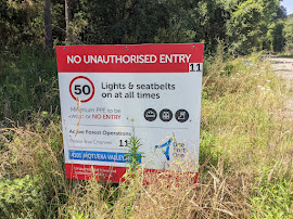
We saw this sign:
I said "Well, thank god for that. Let's go and get brunch".
