Difference between revisions of "2024-02-25 31 34"
Yerushalmi (talk | contribs) (Created page with "{{subst:Expedition}}") |
m (subst-ing) |
||
| (3 intermediate revisions by 3 users not shown) | |||
| Line 8: | Line 8: | ||
And DON'T FORGET to add your expedition and the best photo you took to the gallery on the Main Page! We'd love to read your report, but that means we first have to discover it! :) | And DON'T FORGET to add your expedition and the best photo you took to the gallery on the Main Page! We'd love to read your report, but that means we first have to discover it! :) | ||
-->{{meetup graticule | -->{{meetup graticule | ||
| − | | lat= | + | | lat=31 |
| − | | lon= | + | | lon=34 |
| − | | date= | + | | date=2024-02-25 |
}}<!-- edit as necessary --> | }}<!-- edit as necessary --> | ||
== Location == | == Location == | ||
| − | + | A field outside the town of Ben Zakkai, which is right next to Yavne. This late in the winter it will probably be full of crops, so I doubt it'll be accessible. | |
== Participants == | == Participants == | ||
| − | + | [[User:Yerushalmi|Yerushalmi]] ([[User talk:Yerushalmi|talk]]) | |
| − | |||
== Plans == | == Plans == | ||
| − | + | Train to Tel Aviv, drop off my wife's artwork at a gallery, train to Yavne, go to the field, discover I can't go to the point, come home. That's the plan. | |
== Expedition == | == Expedition == | ||
| − | + | Train to Tel Aviv and dropping off my wife's artwork went as expected. To understand what happens next, I need to explain that there are two train lines from Tel Aviv that go through Yavne: one to the east and one to the west. Both train lines go to Ashdod afterwards. I needed the Yavne East train station, but the most convenient train from the area of the art gallery went to Yavne West. Moovit recommended I take the train through Yavne West to Ashdod, wait three minutes, and take a train back north from Ashdod to Yavne East. | |
| − | + | I reached Ashdod with no trouble, but then came my mistake: the two northbound trains were scheduled very close to one another and I got on the wrong one, finding myself back in Yavne West. | |
| − | + | ||
| + | This was a recoverable error. I took a bus across Yavne to the southern edge, where I would need to walk across into Ben Zakkai. I've been challenging myself more lately to use printed maps, so I headed south after the bus stop - but then I realized I went too far south, past all the roads that crossed the creek, and I would need to cross it myself. | ||
| + | |||
| + | Luckily, however, the creek was not only very low, but the denizens of Yavne and Ben Zakkai provided a nice little makeshift bridge out of rubbish: | ||
| + | |||
| + | [[File:20240225_152042.jpg|400px]] | ||
| + | |||
| + | From there it was a brisk walk through Ben Zakkai to the field, which was, as expected, covered with crops: | ||
| + | [[File:20240225_154803.jpg|400px]] | ||
| + | |||
| + | You might be able to see a sort of golf cart in the distance of that photo. When I first got to the field, there was a man in it, then he walked off to the left behind the bushes there. I didn't call out to him because I wasn't sure what field I'd need to enter - and by the time I realized it was this field, he was gone. The field had these furrows in it, presumably from similar golf carts, which implied I could walk to the point if I chose the correct already-trampled row. But I wasn't going to do it without permission. | ||
| + | |||
| + | I checked how long I had until the next train, and as a result was able to wait around for about half an hour, but he didn't return. So I accepted the No Trespassing consolation prize and went home. | ||
| + | |||
| + | On the way home I discovered I had left my jacket somewhere along the way, which is depressing. | ||
== Photos == | == Photos == | ||
| − | < | + | <gallery> |
| − | + | File:20240225_152042.jpg | A river crossing | |
| − | + | File:20240225_153329.jpg | I saw a bird | |
| − | + | File:20240225_154803.jpg | Crops | |
</gallery> | </gallery> | ||
== Achievements == | == Achievements == | ||
{{#vardefine:ribbonwidth|100%}} | {{#vardefine:ribbonwidth|100%}} | ||
| − | + | {{No trespassing | |
| − | + | | latitude = 31 | |
| − | + | | longitude = 34 | |
| − | + | | date = 2024-02-25 | |
| − | + | | name = Yerushalmi | |
| + | | image = 20240225_154803.jpg | ||
| + | | distance = 200 meters | ||
| − | + | }} | |
| − | + | __NOTOC__ | |
| − | |||
| − | |||
| − | |||
| − | |||
| − | |||
| − | |||
| − | |||
[[Category:Expeditions]] | [[Category:Expeditions]] | ||
| − | |||
[[Category:Expeditions with photos]] | [[Category:Expeditions with photos]] | ||
| − | |||
| − | |||
| − | |||
| − | |||
| − | |||
| − | |||
| − | |||
| − | |||
| − | |||
[[Category:Coordinates not reached]] | [[Category:Coordinates not reached]] | ||
| − | |||
| − | |||
| − | |||
| − | |||
| − | |||
[[Category:Not reached - No public access]] | [[Category:Not reached - No public access]] | ||
| − | + | {{location|IL|M|RH}} | |
| − | |||
| − | |||
| − | |||
| − | |||
| − | |||
| − | |||
| − | |||
Latest revision as of 21:15, 24 May 2024
| Sun 25 Feb 2024 in 31,34: 31.8523079, 34.7234192 geohashing.info google osm bing/os kml crox |
Location
A field outside the town of Ben Zakkai, which is right next to Yavne. This late in the winter it will probably be full of crops, so I doubt it'll be accessible.
Participants
Plans
Train to Tel Aviv, drop off my wife's artwork at a gallery, train to Yavne, go to the field, discover I can't go to the point, come home. That's the plan.
Expedition
Train to Tel Aviv and dropping off my wife's artwork went as expected. To understand what happens next, I need to explain that there are two train lines from Tel Aviv that go through Yavne: one to the east and one to the west. Both train lines go to Ashdod afterwards. I needed the Yavne East train station, but the most convenient train from the area of the art gallery went to Yavne West. Moovit recommended I take the train through Yavne West to Ashdod, wait three minutes, and take a train back north from Ashdod to Yavne East.
I reached Ashdod with no trouble, but then came my mistake: the two northbound trains were scheduled very close to one another and I got on the wrong one, finding myself back in Yavne West.
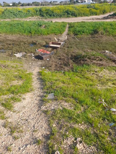
This was a recoverable error. I took a bus across Yavne to the southern edge, where I would need to walk across into Ben Zakkai. I've been challenging myself more lately to use printed maps, so I headed south after the bus stop - but then I realized I went too far south, past all the roads that crossed the creek, and I would need to cross it myself.
Luckily, however, the creek was not only very low, but the denizens of Yavne and Ben Zakkai provided a nice little makeshift bridge out of rubbish:
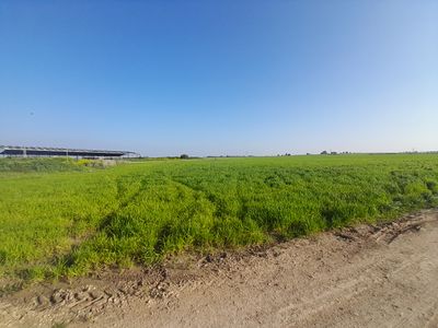
From there it was a brisk walk through Ben Zakkai to the field, which was, as expected, covered with crops:

You might be able to see a sort of golf cart in the distance of that photo. When I first got to the field, there was a man in it, then he walked off to the left behind the bushes there. I didn't call out to him because I wasn't sure what field I'd need to enter - and by the time I realized it was this field, he was gone. The field had these furrows in it, presumably from similar golf carts, which implied I could walk to the point if I chose the correct already-trampled row. But I wasn't going to do it without permission.
I checked how long I had until the next train, and as a result was able to wait around for about half an hour, but he didn't return. So I accepted the No Trespassing consolation prize and went home.
On the way home I discovered I had left my jacket somewhere along the way, which is depressing.
Photos
Achievements
Yerushalmi earned the No trespassing consolation prize
|


