Difference between revisions of "2024-06-16 32 35"
Yerushalmi (talk | contribs) (Created page with "{{subst:Expedition}}") |
Yerushalmi (talk | contribs) |
||
| Line 9: | Line 9: | ||
-->{{meetup graticule|date=2024-06-16|lat=32|lon=35}} | -->{{meetup graticule|date=2024-06-16|lat=32|lon=35}} | ||
== Location == | == Location == | ||
| − | + | In a forest outside Kibbutz Pelech, way up north. Not far from a path. | |
== Participants == | == Participants == | ||
| − | + | [[User:Yerushalmi|Yerushalmi]] ([[User talk:Yerushalmi|talk]]) | |
| − | |||
== Plans == | == Plans == | ||
| − | + | I have to go to Haifa to pick up my wife's artwork. And I have to go by car this time, not train. Depending on how early I leave, I'll go to the point either before or after the pickup. Shouldn't be too difficult: there's a road to an army base that goes parallel to the point on the west, or as a alternative I'll go to the kibbutz and go down the path. | |
| + | |||
| + | One major consideration: half of the North of Israel is on fire right now because of rocket attacks from Hizbullah in Lebanon. Currently there is no indication that this specific area is affected - neither by the fires, nor the rockets, nor the heatwave we had this weekend - but I'll need to double-check before I leave that everything is okay. | ||
== Expedition == | == Expedition == | ||
| − | + | It was a bit borderline whether I'd go to the point first or second, but knowing that this particular gallery is very strict about its closing hours I decided to pick up the artwork first. This went without a hitch (I even found parking immediately!). | |
| + | |||
| + | Once back in the car, I double-checked that nothing had changed since that morning; everything seemed fine. | ||
| + | |||
| + | So I drove north on 22, then east on 85, looking for the left turn towards the army base. It had been very difficult to even find the ''name'' of the army base; I suspect it's no longer in use. But I found the turnoff without a problem. | ||
| + | |||
| + | As I drove north on the road towards the base, I started to get nervous. There were pallets of strange objects on the side of the road, and megaphones attached to the top of telephone poles. The road was entirely abandoned, but I started to suspect I was approaching a place I was not allowed to be. | ||
| + | |||
| + | Well, according to the satellite map there seems to be some kind of path coming off the road to the east, which is what I would need to get to the point. So I'll go to that turnoff but no farther. | ||
| + | |||
| + | Unfortunately, the path did not exist. In fact the east side of the road was entirely inaccessible due to being at the bottom of a large cliff. | ||
| + | |||
| + | Okay, time for plan B: the path from the kibbutz. I did a U-turn and headed back to route 85, trying to find the turnoff to the kibbutz. I drove all the way to Carmiel, realized I had gone too far, drove all the way back to the turnoff from the army base, and then back again - no sign for the kibbutz. Odd. | ||
| + | |||
| + | Okay, let's figure this out a bit more closely. Looking at the map, and according to GPS, the best route is to go straight through an Arab village - not the best of ideas. What's my other option? I see, route 854. Another U-turn, and I turn off onto route 854. | ||
| + | |||
| + | Almost immediately I see signs saying the distances to the various towns in the area - including Pelech. Great! Almost immediately I find myself driving behind a slow-moving bus, with a double-line dividing traffic so I can't pass it. Not great! I crawled behind that bus for the next 14 kilometers until the bus and I finally entered Tuval, which is connected to Pelech. I pulled over to check the map, and discovered that GPS jamming was active. That's okay, I can still navigate; I figured out exactly where I needed to go, and reached Pelech with no more issues (signage helped). | ||
| + | |||
| + | After a false start or two I found the path I needed to reach and started to drive down it - but not far down there was a cattle grid, which I don't entirely trust my car to handle (it'll probably be fine, but why take the chance?). Another U-turn, find a place to park - surprisingly difficult - eat lunch, then take my hiking backpack and set off down the road. GPS is still jammed, so good thing I took printed-out maps! Though in retrospect I should've printed out a second copy to put on the dashboard like I do sometimes. | ||
| + | |||
| + | The path was extremely long but easy to follow, passing some greenhouses and a farm full of cows. When I was close enough to the point I pulled out the close-up satellite photo and began carefully navigating through the thorns. I checked my phone; GPS jamming is still active. So I have to figure out where the point is on my own. | ||
| + | |||
| + | Here's the satellite photo: | ||
| + | |||
| + | [[File:canvas.png|400px]] | ||
| + | |||
| + | Step 1: turn south from the trail at the pointy bit. Easy enough. | ||
| + | |||
| + | Step 2: There's a blob-ish of trees going from northeast to southwest. I want to stay to the east of that. | ||
| + | |||
| + | Steps 3-6: Start counting trees. I should be passing three small trees (3), then a medium one (4), then a brown clearing with a little tiny green bit in the middle (5). Just south of the clearing there is a tree that sticks out in the blob a bit(6), behind which is the point. | ||
| + | |||
| + | I found the clearing, but discovered it was very difficult to figure out exactly which trees in the blob to my right are which. | ||
| + | |||
| + | I put down my hiking backpack. Time to concentrate: | ||
| + | |||
| + | [[File:20240616_151451.jpg|400px]] | ||
| + | |||
| + | All right. The tree in the rear-center of this photo is #4, and the small one behind it is one of the three small trees making up #3. That makes the bush directly in front of me the tiny green bit in clearing #5. | ||
| + | |||
| + | [[File:20240616_151501.jpg|400px]] | ||
| + | |||
| + | And in this photo, taken from the clearing facing west, you can see the large tree to the right of the 6, the tree that the 6 is sitting on top of, and the smaller tree to the southeast of the 6. None of these are tree #6 itself. | ||
| + | |||
| + | [[File:20240616_151516.jpg|400px]] | ||
| + | |||
| + | That makes the big tree occupying the right half of this photo, taken from the clearing facing southwest, tree #6. And to the left of that tree, slightly behind it, is exposed bedrock - which matches perfectly with the fact that today's point is on ground that is white, not brown! I got it! | ||
| + | |||
| + | I reached the point, took my usual panorama, then picked up a bunch of small rocks to spell out XKCD. (Never pick up a rock in the wilderness; you never know what snake or scorpion might be underneath it. I kicked each rock over with my boots before lifting it.) | ||
| + | |||
| + | Thus successful, I walked back to the car. I felt genuinely exhausted and had to rest multiple times; it's been way too long (over a month) since I did a major walking geohash like this. | ||
| − | + | Four hours after I left Haifa (and here I thought the geohashing detour would be a quick half-hour, hour maximum!) I reached the car again, and drove home. | |
| − | |||
== Photos == | == Photos == | ||
| − | <! | + | <gallery> |
| − | + | File:20240616_141510.jpg | This very worrying sign says "Warning! UV Radiation. Entry for authorized personnel only." | |
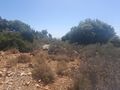
| − | + | File:20240616_143322.jpg | I'm terrible at photographing landscapes. Trust me when I say this was a lot more beautiful in person. | |
| − | + | File:20240616_143325.jpg | Ditto | |
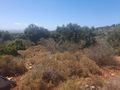
| + | File:20240616_143802.jpg | This landscape didn't turn out too badly | ||
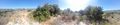
| + | File:20240616_145547.jpg | Nice valley | ||
| + | File:20240616_151451.jpg | Slowly piecing together where I need to go. If I'm in the clearing here... | ||
| + | File:20240616_151501.jpg | And these are the trees at the lower end of the blob... | ||
| + | File:20240616_151516.jpg | Then I need to be standing on that rock there | ||
| + | File:20240616_151542.jpg | Panorama at the point | ||
| + | File:20240616_151604.jpg | The rock before XKCD | ||
| + | File:20240616_152208.jpg | The rock after XKCD | ||
</gallery> | </gallery> | ||
| + | |||
== Achievements == | == Achievements == | ||
| − | {{ | + | {{No_batteries_geohash |
| − | |||
| − | + | | latitude = 32 | |
| − | + | | longitude = 35 | |
| − | + | | date = 2024-06-16 | |
| − | + | | name = Yerushalmi | |
| − | + | }} | |
| − | |||
| − | |||
| − | |||
| − | |||
[[Category:Expeditions]] | [[Category:Expeditions]] | ||
| − | |||
[[Category:Expeditions with photos]] | [[Category:Expeditions with photos]] | ||
| − | |||
| − | |||
| − | |||
| − | |||
[[Category:Coordinates reached]] | [[Category:Coordinates reached]] | ||
| − | |||
| − | |||
| − | |||
| − | |||
| − | |||
| − | |||
| − | |||
| − | |||
| − | |||
| − | |||
| − | |||
| − | |||
| − | |||
| − | |||
Revision as of 09:59, 17 June 2024
| Sun 16 Jun 2024 in 32,35: 32.9301731, 35.2214024 geohashing.info google osm bing/os kml crox |
Location
In a forest outside Kibbutz Pelech, way up north. Not far from a path.
Participants
Plans
I have to go to Haifa to pick up my wife's artwork. And I have to go by car this time, not train. Depending on how early I leave, I'll go to the point either before or after the pickup. Shouldn't be too difficult: there's a road to an army base that goes parallel to the point on the west, or as a alternative I'll go to the kibbutz and go down the path.
One major consideration: half of the North of Israel is on fire right now because of rocket attacks from Hizbullah in Lebanon. Currently there is no indication that this specific area is affected - neither by the fires, nor the rockets, nor the heatwave we had this weekend - but I'll need to double-check before I leave that everything is okay.
Expedition
It was a bit borderline whether I'd go to the point first or second, but knowing that this particular gallery is very strict about its closing hours I decided to pick up the artwork first. This went without a hitch (I even found parking immediately!).
Once back in the car, I double-checked that nothing had changed since that morning; everything seemed fine.
So I drove north on 22, then east on 85, looking for the left turn towards the army base. It had been very difficult to even find the name of the army base; I suspect it's no longer in use. But I found the turnoff without a problem.
As I drove north on the road towards the base, I started to get nervous. There were pallets of strange objects on the side of the road, and megaphones attached to the top of telephone poles. The road was entirely abandoned, but I started to suspect I was approaching a place I was not allowed to be.
Well, according to the satellite map there seems to be some kind of path coming off the road to the east, which is what I would need to get to the point. So I'll go to that turnoff but no farther.
Unfortunately, the path did not exist. In fact the east side of the road was entirely inaccessible due to being at the bottom of a large cliff.
Okay, time for plan B: the path from the kibbutz. I did a U-turn and headed back to route 85, trying to find the turnoff to the kibbutz. I drove all the way to Carmiel, realized I had gone too far, drove all the way back to the turnoff from the army base, and then back again - no sign for the kibbutz. Odd.
Okay, let's figure this out a bit more closely. Looking at the map, and according to GPS, the best route is to go straight through an Arab village - not the best of ideas. What's my other option? I see, route 854. Another U-turn, and I turn off onto route 854.
Almost immediately I see signs saying the distances to the various towns in the area - including Pelech. Great! Almost immediately I find myself driving behind a slow-moving bus, with a double-line dividing traffic so I can't pass it. Not great! I crawled behind that bus for the next 14 kilometers until the bus and I finally entered Tuval, which is connected to Pelech. I pulled over to check the map, and discovered that GPS jamming was active. That's okay, I can still navigate; I figured out exactly where I needed to go, and reached Pelech with no more issues (signage helped).
After a false start or two I found the path I needed to reach and started to drive down it - but not far down there was a cattle grid, which I don't entirely trust my car to handle (it'll probably be fine, but why take the chance?). Another U-turn, find a place to park - surprisingly difficult - eat lunch, then take my hiking backpack and set off down the road. GPS is still jammed, so good thing I took printed-out maps! Though in retrospect I should've printed out a second copy to put on the dashboard like I do sometimes.
The path was extremely long but easy to follow, passing some greenhouses and a farm full of cows. When I was close enough to the point I pulled out the close-up satellite photo and began carefully navigating through the thorns. I checked my phone; GPS jamming is still active. So I have to figure out where the point is on my own.
Here's the satellite photo:

Step 1: turn south from the trail at the pointy bit. Easy enough.
Step 2: There's a blob-ish of trees going from northeast to southwest. I want to stay to the east of that.
Steps 3-6: Start counting trees. I should be passing three small trees (3), then a medium one (4), then a brown clearing with a little tiny green bit in the middle (5). Just south of the clearing there is a tree that sticks out in the blob a bit(6), behind which is the point.
I found the clearing, but discovered it was very difficult to figure out exactly which trees in the blob to my right are which.
I put down my hiking backpack. Time to concentrate:

All right. The tree in the rear-center of this photo is #4, and the small one behind it is one of the three small trees making up #3. That makes the bush directly in front of me the tiny green bit in clearing #5.

And in this photo, taken from the clearing facing west, you can see the large tree to the right of the 6, the tree that the 6 is sitting on top of, and the smaller tree to the southeast of the 6. None of these are tree #6 itself.

That makes the big tree occupying the right half of this photo, taken from the clearing facing southwest, tree #6. And to the left of that tree, slightly behind it, is exposed bedrock - which matches perfectly with the fact that today's point is on ground that is white, not brown! I got it!
I reached the point, took my usual panorama, then picked up a bunch of small rocks to spell out XKCD. (Never pick up a rock in the wilderness; you never know what snake or scorpion might be underneath it. I kicked each rock over with my boots before lifting it.)
Thus successful, I walked back to the car. I felt genuinely exhausted and had to rest multiple times; it's been way too long (over a month) since I did a major walking geohash like this.
Four hours after I left Haifa (and here I thought the geohashing detour would be a quick half-hour, hour maximum!) I reached the car again, and drove home.
Photos

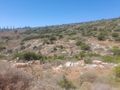
This very worrying sign says "Warning! UV Radiation. Entry for authorized personnel only."
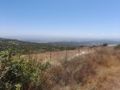
I'm terrible at photographing landscapes. Trust me when I say this was a lot more beautiful in person.
Ditto

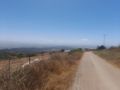
This landscape didn't turn out too badly
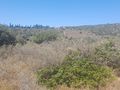
Nice valley
Slowly piecing together where I need to go. If I'm in the clearing here...
And these are the trees at the lower end of the blob...
Then I need to be standing on that rock there
Panorama at the point
The rock before XKCD
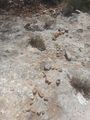
The rock after XKCD


Achievements
Yerushalmi earned the No Batteries Geohash Achievement
|