Difference between revisions of "2024-07-30 -12 130"
From Geohashing
Felix Dance (talk | contribs) (Created expedition page) |
Felix Dance (talk | contribs) m |
||
| Line 24: | Line 24: | ||
== Achievements == | == Achievements == | ||
| + | {{Walk geohash | ||
| + | |||
| + | | latitude = -12 | ||
| + | | longitude = 130 | ||
| + | | date = 2024-07-30 | ||
| + | | name = Tali | ||
| + | | distance = ~2kms | ||
| + | | image = 2024-07-30_-12_130_Felix Dance _1722416638285.jpg | ||
| + | |||
| + | }} | ||
| + | |||
{{Puppet Master Geohash | {{Puppet Master Geohash | ||
Revision as of 03:48, 1 August 2024

| Tue 30 Jul 2024 in -12,130: -12.3720911, 130.8623167 geohashing.info google osm bing/os kml crox |
Location
The centre of the Rapid Creek Picnic Area, Brinkin, Darwin.
Participants
- Tali
Expedition
Tali went for a walk after work and reached this geohashing point.
Photos
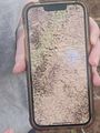
GPS proof
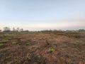
Looking North
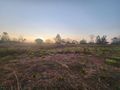
Looking west
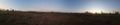
Looking east


Achievements
Tali earned the Walk geohash Achievement
|
Felix earned the Puppet Master Geohash achievement
|