Difference between revisions of "2024-08-12 48 7"
From Geohashing
(Fix category) |
(→Achievements) |
||
| (2 intermediate revisions by 2 users not shown) | |||
| Line 9: | Line 9: | ||
== Participants == | == Participants == | ||
* [[User:Baarde|Baarde]] | * [[User:Baarde|Baarde]] | ||
| + | |||
| + | == Expedition == | ||
| + | The coordinates were located in a meadow between Obernai hospital and the fire station. I took the 19:16 train from Sélestat, then cycled to the coordinates. I recorded proof, cycled back to the train station, and returned with the 20:26 train to Sélestat. | ||
| + | |||
| + | == Photos == | ||
| + | <gallery> | ||
| + | File:2024-08-12 48 7 01.jpg | In Obernai | ||
| + | File:2024-08-12 48 7 02.png | Coordinates reached | ||
| + | File:2024-08-12 48 7 03.jpg | Surroundings (fire station) | ||
| + | File:2024-08-12 48 7 04.jpg | Surroundings (hospital) | ||
| + | File:2024-08-12 48 7 05.jpg | Stupid grin | ||
| + | </gallery> | ||
| + | |||
| + | == Achievements == | ||
| + | {{#vardefine:ribbonwidth|100%}} | ||
| + | {{land geohash | ||
| + | | latitude = 48 | ||
| + | | longitude = 7 | ||
| + | | date = 2024-08-12 | ||
| + | | name = [[User:Baarde|Baarde]] | ||
| + | }} | ||
__NOTOC__ | __NOTOC__ | ||
| − | [[Category: | + | [[Category:Expeditions]] |
| + | [[Category:Expeditions with photos]] | ||
| + | [[Category:Coordinates reached]] | ||
| + | {{location|FR|67}} | ||
Latest revision as of 08:47, 14 August 2024
| Mon 12 Aug 2024 in 48,7: 48.4553792, 7.4902458 geohashing.info google osm bing/os kml crox |
Location
In a meadow in Obernai.
Participants
Expedition
The coordinates were located in a meadow between Obernai hospital and the fire station. I took the 19:16 train from Sélestat, then cycled to the coordinates. I recorded proof, cycled back to the train station, and returned with the 20:26 train to Sélestat.
Photos
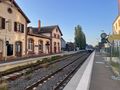
In Obernai
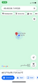
Coordinates reached
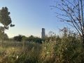
Surroundings (fire station)
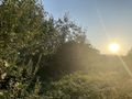
Surroundings (hospital)

Stupid grin


Achievements
Baarde earned the Land geohash achievement
|