Difference between revisions of "2024-08-14 52 5"
Coyotebush (talk | contribs) ([live picture]Side path [https://openstreetmap.org/?mlat=52.01348056&mlon=5.91760278&zoom=16 @52.0135,5.9176]) |
Coyotebush (talk | contribs) (→Expedition: shared story) |
||
| (9 intermediate revisions by 4 users not shown) | |||
| Line 1: | Line 1: | ||
| − | |||
| − | |||
| − | |||
| − | |||
| − | |||
| − | |||
{{meetup graticule|date=2024-08-14|lat=52|lon=5}} | {{meetup graticule|date=2024-08-14|lat=52|lon=5}} | ||
== Location == | == Location == | ||
| Line 17: | Line 11: | ||
== Expedition == | == Expedition == | ||
| + | Met at Utrecht Centraal and rode the train to Arnhem together. By the time we arrived, it was raining heavily. | ||
| + | *We're on a bus in the rain -- [[User:Coyotebush|Coyotebush]] ([[User talk:Coyotebush|talk]]) [https://openstreetmap.org/?mlat=51.98611077&mlon=5.90670274&zoom=16 @51.9861,5.9067] 17:12, 14 August 2024 (GMT+02:00) | ||
| + | Got off the bus at Moscowa/Schlemseweg and dashed across the road to a little-trafficked and increasingly muddy bike path. Once we saw the corner of the museum fence, we knew the point was close. Took the second trail to the right, which had practically turned into a stream. The forest was easy to walk into, and two phones had slightly different ideas of the point. | ||
| + | Afterwards, we retraced our steps to the bus stop, arriving just in time for a return bus. Back in central Arnhem, the rain had mostly let up, and we went out for Korean food before parting ways back at the train station. | ||
| − | |||
== Photos == | == Photos == | ||
<!-- | <!-- | ||
| Line 36: | Line 33: | ||
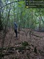
Image:2024-08-14_52_5_coyotebush_1723662722313.jpg|Side path [https://openstreetmap.org/?mlat=52.01348056&mlon=5.91760278&zoom=16 @52.0135,5.9176] | Image:2024-08-14_52_5_coyotebush_1723662722313.jpg|Side path [https://openstreetmap.org/?mlat=52.01348056&mlon=5.91760278&zoom=16 @52.0135,5.9176] | ||
| + | |||
| + | Image:2024-08-14_52_5_coyotebush_1723662756244.jpg|Disagreement [https://openstreetmap.org/?mlat=52.01357222&mlon=5.91686389&zoom=16 @52.0136,5.9169] | ||
| + | |||
| + | Image:2024-08-14_52_5_coyotebush_1723662767174.jpg|Hashers [https://openstreetmap.org/?mlat=52.01357500&mlon=5.91684722&zoom=16 @52.0136,5.9168] | ||
| + | |||
| + | 2024-08-14_52_5_Hash_reached.jpeg|MyrtleGlacy's Proof | ||
</gallery> | </gallery> | ||
| − | |||
== Achievements == | == Achievements == | ||
{{#vardefine:ribbonwidth|100%}} | {{#vardefine:ribbonwidth|100%}} | ||
| − | + | {{meet-up|date=2024-08-14|latitude=52|longitude=5|name=[[User:MyrtleGlacy|MyrtleGlacy]] and [[User:Coyotebush|coyotebush]]|other=each other|image=2024-08-14_52_5_coyotebush_1723662767174.jpg}} | |
| − | [[ | + | |
| + | {{Drowned rat geohash | ||
| + | |||
| + | | latitude = 52 | ||
| + | | longitude = 5 | ||
| + | | date = 2024-08-14 | ||
| + | | name = [[User:Coyotebush|coyotebush]] and [[User:MyrtleGlacy|MyrtleGlacy]] | ||
| + | | image = 2024-08-14_52_5_coyotebush_1723662767174.jpg | ||
| + | | reason = heavy rain | ||
| + | | | ||
| − | + | }} | |
| − | |||
| + | __NOTOC__ | ||
[[Category:Expeditions]] | [[Category:Expeditions]] | ||
[[Category:Expeditions with photos]] | [[Category:Expeditions with photos]] | ||
| − | |||
[[Category:Coordinates reached]] | [[Category:Coordinates reached]] | ||
| − | + | {{location|NL|GE}} | |
| − | |||
| − | |||
| − | |||
| − | |||
| − | |||
| − | |||
| − | |||
Latest revision as of 11:03, 24 August 2024
| Wed 14 Aug 2024 in 52,5: 52.0135924, 5.9168611 geohashing.info google osm bing/os kml crox |
Location
In the woods just outside the Netherlands Open Air Museum in Arnhem.
Participants
Plans
Meet at the nearest bus stop at 17:20.
Expedition
Met at Utrecht Centraal and rode the train to Arnhem together. By the time we arrived, it was raining heavily.
- We're on a bus in the rain -- Coyotebush (talk) @51.9861,5.9067 17:12, 14 August 2024 (GMT+02:00)
Got off the bus at Moscowa/Schlemseweg and dashed across the road to a little-trafficked and increasingly muddy bike path. Once we saw the corner of the museum fence, we knew the point was close. Took the second trail to the right, which had practically turned into a stream. The forest was easy to walk into, and two phones had slightly different ideas of the point.
Afterwards, we retraced our steps to the bus stop, arriving just in time for a return bus. Back in central Arnhem, the rain had mostly let up, and we went out for Korean food before parting ways back at the train station.
Photos
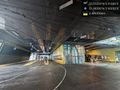
Waiting for a bus @51.9839,5.9005
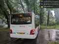
Goodbye bus @52.0077,5.9140
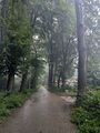
Main path
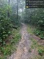
Side path @52.0135,5.9176
Disagreement @52.0136,5.9169
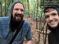
Hashers @52.0136,5.9168

MyrtleGlacy's Proof


Achievements
MyrtleGlacy and coyotebush earned the Meet-up achievement
|
coyotebush and MyrtleGlacy earned the Drowned Rat Geohash Achievement
|