Difference between revisions of "2024-08-18 40 -74"
Yerushalmi (talk | contribs) |
m (Location) |
||
| Line 49: | Line 49: | ||
[[Category:Coordinates not reached]] | [[Category:Coordinates not reached]] | ||
[[Category:Not reached - No public access]] | [[Category:Not reached - No public access]] | ||
| + | {{location|US|NY|KI}} | ||
Latest revision as of 16:42, 25 August 2024
| Sun 18 Aug 2024 in 40,-74: 40.6560965, -74.0165447 geohashing.info google osm bing/os kml crox |
Location
On a pier on the western end of Long Island, in Brooklyn, NY
Participants
Yerushalmi (talk), his wife, #1, #3, #4
Plans
I'm visiting my parents in NJ and keeping an eye out for good geohashes. We'll drive down to Brooklyn, go to the pier, then spend the rest of the day in the city.
Expedition
The drive to the neighborhood of the pier was fine, but our originally intended route (park on 42nd street, walk northwest) was stymied by massive amounts of construction and closed roads. I and #3 approached a guard at the construction site who told us that access to Bush Terminal Park was from down on 50th street.
We returned to the car and drove down to 50th street. After a short encounter with more guards (we had started driving towards a restricted part of the pier), we found a parking space and walked into the park.
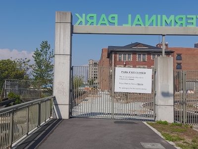
We walked past a couple of soccer fields and onto a path along the beach that led to the piers. The piers we passed looked interesting and fun, and we resolved to check them out on the way back, but the pier we wanted to reach...
Ah well. We enjoyed the breeze off the river, saw the Statue of Liberty off in the distance, and the kids collected some seashells. Not a complete waste of a journey.
Photos


