Difference between revisions of "2024-09-17 32 35"
Yerushalmi (talk | contribs) (Created page with "{{subst:Expedition}}") |
Yerushalmi (talk | contribs) |
||
| Line 9: | Line 9: | ||
-->{{meetup graticule|date=2024-09-17|lat=32|lon=35}} | -->{{meetup graticule|date=2024-09-17|lat=32|lon=35}} | ||
== Location == | == Location == | ||
| − | + | Farmland just outside of Haifa. | |
== Participants == | == Participants == | ||
| − | + | [[User:Yerushalmi|Yerushalmi]] ([[User talk:Yerushalmi|talk]]) | |
| − | |||
== Plans == | == Plans == | ||
| − | + | I had to deliver artwork to Haifa sometime this week, so I picked a day when the point was in the area. I'll take a train day: train all the way to Haifa, drop off the art, then further train and/or bus to the area of the point. I'm optimistic the point will be reachable, since it's the middle of the summer so the crops will likely have long been harvested. | |
| + | |||
| + | GPS jamming in the area is likely, so I'll bring paper maps as backup. | ||
== Expedition == | == Expedition == | ||
| − | + | I got on an early train and davened with the train minyan, then switched to the Haifabound train once I reached Tel Aviv. I got off at the Haifa - Merkaz Hashmona train station, lugged the paintings up the massive hill to the art gallery, then checked Moovit. Naturally, there was GPS jamming (Haifa is a target of Hizbullah missiles), so I couldn't know where the buses were. But I worked out that the fastest route would be to return to the train, continue to the Merkazit Hamifratz station, then take a bus from there; I had multiple to choose from. | |
| + | |||
| + | The Merkazit Hamifratz station is extremely stupidly built. You can't get from the train to the bus, even though they're separate floors of the same building, without going outside and coming back inside, which means you pointlessly have to go through security again. This did not materially affect the expedition, but I wanted to whine about it anyway. | ||
| + | |||
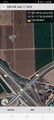
| + | I took the bus (GPS jamming is still active) one stop to the Yagur interchange (GPS jamming is still active), an interchange I've been in many times while geohashing in the North. I crossed to the northern corner of the intersection and surveyed the farmland I'd be heading into: | ||
| + | |||
| + | [[File:20240917_131705.jpg|400px]] | ||
| + | |||
| + | Comparing the lines in the field to the lines in the satellite photo and on my printed map, I realized the point was probably right next to that long metal centipede apparatus thing. I see those in fields all the time, and I've always wondered if they're a framework for connecting harvesting blades or what. Well, I'm about to get close enough to find out. | ||
| − | + | But first I need to find a way to get over the fence and down there. Checking the map, and checking the intersection, it looks like there's path on the east side that descends, does some twists and turns, then goes under the highway and into the fields, becoming the path that's on the *other* side of the strip of trees (not the one visible right behind the fence) | |
| − | |||
| − | + | So this I did. Cross the intersection to the eastern corner, descend from the highway via the path, which I was surprised to discover was actually paved and included a bridge that crossed, in two halves, the Kishon River! The river turns out to be the reason for the strip of greenery in the above photo; it's hidden underneath all that foliage, and it's a good thing I didn't try to cross it without the help of a bridge (though the river isn't very high this time of year). | |
| − | |||
| − | |||
| − | |||
| − | |||
| − | |||
| − | + | So now I'm walking on the path along the field, and checking GPS... nope, still jammed. I'll have to very carefully measure, when I get there, how far I need to be from the edges of the field to figure out where *inside* the field is the point. That's going to be annoying. | |
| − | |||
| − | |||
| − | + | Approaching more, and more, and more, checking the satellite photo all the time to make sure the paths between the fields match what I expect, now I've reached the intersection where I need to leave the path and go directly into the field and start measuring, and.... is that a little blue dot? | |
| − | |||
| − | |||
| − | |||
| − | + | [[File:Screenshot_20240917_125502_Geohash Droid.jpg|400px]] | |
| − | |||
| − | [[ | ||
| − | |||
| − | + | Just in time, GPS jamming ended and I know exactly where I am! | |
| − | |||
| − | |||
| − | |||
| − | |||
| − | |||
| − | + | From there it was an easy walk to the point, which was right next to - even slightly under - what turned out to be a piece of basic immigration equipment. | |
| − | |||
| − | + | I took the reverse route home: walk back to the bus stop, bus to Merkazit Hamifratz, train to Tel Aviv, switch to the train to Jerusalem, and arrive home. | |
| − | |||
| − | |||
| − | |||
| − | |||
| − | |||
| − | |||
| − | + | == Photos == | |
| − | + | <gallery> | |
| + | File:20240917_124336.jpg | Bridge over the Kishon River | ||
| + | File:20240917_124345.jpg | Other side of the bridge | ||
| + | File:20240917_124649.jpg | Under the highway, the river to my left | ||
| + | File:20240917_124740.jpg | The point is in yonder field | ||
| + | File:20240917_125016.jpg | Somewhere in this direction | ||
| + | File:Screenshot_20240917_125103_Geohash Droid.jpg | According to this I'm in the airport in Amman, nowhere near the point! | ||
| + | File:20240917_125134.jpg | The first intersection between fields | ||
| + | File:Screenshot_20240917_125502_Geohash Droid.jpg | It's a miracle! | ||
| + | File:Screenshot_20240917_125630_Geohash Droid.jpg | Proof | ||
| + | File:20240917_125533.jpg | Pipes that drop water onto the crops | ||
| + | File:20240917_125535.jpg | Slightly more in focus | ||
| + | File:20240917_125733.jpg | XKCD made out of leftover stalks of whatever-it-was that grew here | ||
| + | File:20240917_125739.jpg | Panorama at the point. Check out that mountain and that sky! | ||
| + | File:20240917_131705.jpg | Belatedly, I realized I hadn't photographed the survey point from the intersection, so I did that on my way back. | ||
| + | </gallery> | ||
| − | + | [[Category:Expeditions]] | |
| + | [[Category:Expeditions with photos]] | ||
| + | [[Category:Coordinates reached]] | ||
Revision as of 18:03, 19 September 2024
| Tue 17 Sep 2024 in 32,35: 32.7590060, 35.0696509 geohashing.info google osm bing/os kml crox |
Contents
Location
Farmland just outside of Haifa.
Participants
Plans
I had to deliver artwork to Haifa sometime this week, so I picked a day when the point was in the area. I'll take a train day: train all the way to Haifa, drop off the art, then further train and/or bus to the area of the point. I'm optimistic the point will be reachable, since it's the middle of the summer so the crops will likely have long been harvested.
GPS jamming in the area is likely, so I'll bring paper maps as backup.
Expedition
I got on an early train and davened with the train minyan, then switched to the Haifabound train once I reached Tel Aviv. I got off at the Haifa - Merkaz Hashmona train station, lugged the paintings up the massive hill to the art gallery, then checked Moovit. Naturally, there was GPS jamming (Haifa is a target of Hizbullah missiles), so I couldn't know where the buses were. But I worked out that the fastest route would be to return to the train, continue to the Merkazit Hamifratz station, then take a bus from there; I had multiple to choose from.
The Merkazit Hamifratz station is extremely stupidly built. You can't get from the train to the bus, even though they're separate floors of the same building, without going outside and coming back inside, which means you pointlessly have to go through security again. This did not materially affect the expedition, but I wanted to whine about it anyway.
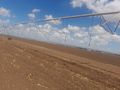
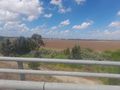
I took the bus (GPS jamming is still active) one stop to the Yagur interchange (GPS jamming is still active), an interchange I've been in many times while geohashing in the North. I crossed to the northern corner of the intersection and surveyed the farmland I'd be heading into:

Comparing the lines in the field to the lines in the satellite photo and on my printed map, I realized the point was probably right next to that long metal centipede apparatus thing. I see those in fields all the time, and I've always wondered if they're a framework for connecting harvesting blades or what. Well, I'm about to get close enough to find out.
But first I need to find a way to get over the fence and down there. Checking the map, and checking the intersection, it looks like there's path on the east side that descends, does some twists and turns, then goes under the highway and into the fields, becoming the path that's on the *other* side of the strip of trees (not the one visible right behind the fence)
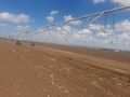
So this I did. Cross the intersection to the eastern corner, descend from the highway via the path, which I was surprised to discover was actually paved and included a bridge that crossed, in two halves, the Kishon River! The river turns out to be the reason for the strip of greenery in the above photo; it's hidden underneath all that foliage, and it's a good thing I didn't try to cross it without the help of a bridge (though the river isn't very high this time of year).
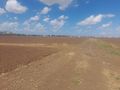
So now I'm walking on the path along the field, and checking GPS... nope, still jammed. I'll have to very carefully measure, when I get there, how far I need to be from the edges of the field to figure out where *inside* the field is the point. That's going to be annoying.
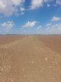
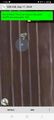
Approaching more, and more, and more, checking the satellite photo all the time to make sure the paths between the fields match what I expect, now I've reached the intersection where I need to leave the path and go directly into the field and start measuring, and.... is that a little blue dot?

Just in time, GPS jamming ended and I know exactly where I am!
From there it was an easy walk to the point, which was right next to - even slightly under - what turned out to be a piece of basic immigration equipment.
I took the reverse route home: walk back to the bus stop, bus to Merkazit Hamifratz, train to Tel Aviv, switch to the train to Jerusalem, and arrive home.
Photos
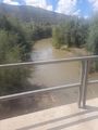
Bridge over the Kishon River
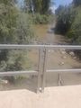
Other side of the bridge
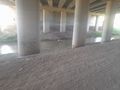
Under the highway, the river to my left

The point is in yonder field
Somewhere in this direction
According to this I'm in the airport in Amman, nowhere near the point!
The first intersection between fields
It's a miracle!
Proof
Pipes that drop water onto the crops
Slightly more in focus
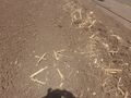
XKCD made out of leftover stalks of whatever-it-was that grew here
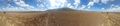
Panorama at the point. Check out that mountain and that sky!
Belatedly, I realized I hadn't photographed the survey point from the intersection, so I did that on my way back.


