Difference between revisions of "2024-09-23 43 -124"
Michael5000 (talk | contribs) |
m |
||
| (2 intermediate revisions by 2 users not shown) | |||
| Line 34: | Line 34: | ||
__NOTOC__ | __NOTOC__ | ||
| − | |||
[[Category:Expeditions]] | [[Category:Expeditions]] | ||
[[Category:Expeditions with photos]] | [[Category:Expeditions with photos]] | ||
| + | [[Category:Coordinates not reached]] | ||
[[Category:Not reached - No public access]] | [[Category:Not reached - No public access]] | ||
| + | {{location|US|OR|CO}} | ||
Latest revision as of 20:21, 29 September 2024
| Mon 23 Sep 2024 in 43,-124: 43.5674531, -124.0955456 geohashing.info google osm bing/os kml crox |
Location
Deep in the woods east of Lakeside.
Participants
Expedition
This was the kind of expedition where you know it's going to take some doing to get to the hashpoint, and that when you get there it's a complete toss-up whether it will actually be accessible.
Fortunately, the getting there was pretty enjoyable. Traveling back to Portland from the South Coast, we stopped and got a good look at Lakeside, a little town I've been passing by without ever really seeing for my entire life. So that was cool, as was a look at some of the hills-and-lakes forest inland from Highway 101 in northern Coos County.
After plenty of driving down increasingly tenuous roads, though, it turned out that the field containing the hashpoint was thoroughly fenced in. Not accessible! Well, we tried.
Photos
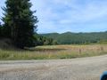
The hashpoint is in this field
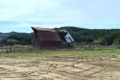
Damaged barn not far away

