Difference between revisions of "2024-10-14 65 25"
(Created page with "{{subst:expedition}}") |
m (Location) |
||
| (One intermediate revision by one other user not shown) | |||
| Line 1: | Line 1: | ||
| − | + | {{meetup graticule|date=2024-10-14|lat=65|lon=25|retro=1}} | |
| − | |||
| − | |||
| − | |||
| − | |||
| − | |||
| − | |||
| − | |||
| − | |||
== Location == | == Location == | ||
| − | + | In a field near Holtinkylä, Oulu. | |
== Participants == | == Participants == | ||
| − | + | *[[User:Kripakko|Kripakko]] | |
| − | |||
| − | == | + | == Expedition == |
| − | + | I decided to do a reverse retro expedition (visit a future day's geohash coordinates) | |
| + | to this hashpoint on the way to [[2024-10-13 65 25]]. | ||
| + | It happened to be only 140 metres off the road that I was going to take on that expedition anyway, | ||
| + | and I would not have time to visit it on the correct day, | ||
| + | so why not pay a visit to it? | ||
| − | + | The hashpoint was on a field where some clover and dandelion had been growing. | |
| − | + | I was not sure if it was going to be harvested before the winter, | |
| + | but in any case these are not valuable crops that anyone would really care about. | ||
| + | Figuring that I would not cause significant damage by walking on it, | ||
| + | I went there and reached the coordinates. | ||
| + | I took a couple of quick photos and then continued cycling. | ||
| − | + | The [[2024-10-13 65 25|main expedition]] page has (will have) | |
| − | + | a more detailed description of the trip and the tracklog. | |
== Photos == | == Photos == | ||
| − | < | + | <gallery perrow="3"> |
| − | Image:2024- | + | Image:2024-10-13 65 25 02-river.jpg | View to the Sanginjoki river some 30 metres away from the hashpoint. |
| − | -- | + | Image:2024-10-13 65 25 03-retro gpsr.jpg | GPS receiver at the hashpoint. |
| − | + | Image:2024-10-13 65 25 04-retro-area.jpg | Surroundings of the hashpoint. | |
</gallery> | </gallery> | ||
| − | |||
| − | |||
| − | |||
| − | |||
__NOTOC__ | __NOTOC__ | ||
| − | |||
| − | |||
| − | |||
| − | |||
| − | |||
| − | |||
| − | |||
| − | |||
| − | + | [[Category:Retro_coordinates_reached]] | |
| − | [[Category: | ||
| − | |||
[[Category:Expeditions with photos]] | [[Category:Expeditions with photos]] | ||
| − | + | {{location|FI|14}} | |
| − | |||
| − | |||
| − | |||
| − | |||
| − | |||
| − | |||
| − | |||
| − | |||
| − | |||
| − | |||
| − | |||
| − | |||
| − | |||
| − | |||
| − | |||
| − | |||
| − | |||
| − | |||
Latest revision as of 20:42, 14 October 2024
| Mon 14 Oct 2024 in 65,25: 65.0036423, 25.7160791 geohashing.info google osm bing/os kml crox |
Location
In a field near Holtinkylä, Oulu.
Participants
Expedition
I decided to do a reverse retro expedition (visit a future day's geohash coordinates) to this hashpoint on the way to 2024-10-13 65 25. It happened to be only 140 metres off the road that I was going to take on that expedition anyway, and I would not have time to visit it on the correct day, so why not pay a visit to it?
The hashpoint was on a field where some clover and dandelion had been growing. I was not sure if it was going to be harvested before the winter, but in any case these are not valuable crops that anyone would really care about. Figuring that I would not cause significant damage by walking on it, I went there and reached the coordinates. I took a couple of quick photos and then continued cycling.
The main expedition page has (will have) a more detailed description of the trip and the tracklog.
Photos
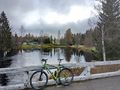
View to the Sanginjoki river some 30 metres away from the hashpoint.
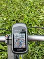
GPS receiver at the hashpoint.
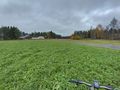
Surroundings of the hashpoint.


