Difference between revisions of "2024-10-03 50 8"
Green guy! (talk | contribs) (Add images and captions; some other improvements) |
Green guy! (talk | contribs) (Add Vexillology achievement and reference the flag in the report) |
||
| (One intermediate revision by the same user not shown) | |||
| Line 1: | Line 1: | ||
| − | |||
| − | |||
| − | |||
{{meetup graticule | {{meetup graticule | ||
| lat=50 | | lat=50 | ||
| Line 25: | Line 22: | ||
== Expedition == | == Expedition == | ||
=== Reaching the coordinates and going for a walk === | === Reaching the coordinates and going for a walk === | ||
| − | Upon arriving at Jügesheim, we entered the residential area from the west and quickly found a roadside parking space for our car. From there, we only had to walk a few meters to reach the coordinates. | + | Upon arriving at Jügesheim, we entered the residential area from the west and quickly found a roadside parking space for our car. From there, we only had to walk a few meters to reach the coordinates. South of the hashpoint, you can see a flag of Germany on a roof. |
<gallery class="center" widths="300px" heights="200px"> | <gallery class="center" widths="300px" heights="200px"> | ||
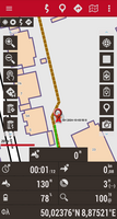
File:Screenshot_20241003-125226_OruxMaps.png|alt="OruxMaps screenshot: standing on the hashpoint"|Coordinates reached! | File:Screenshot_20241003-125226_OruxMaps.png|alt="OruxMaps screenshot: standing on the hashpoint"|Coordinates reached! | ||
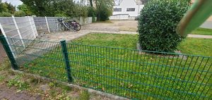
File:OMIMG_20241003_125231.jpg|alt="metal fence in front of lawn, with paved footway behind"|Actually, the hashpoint lies about one meter behind this fence, … | File:OMIMG_20241003_125231.jpg|alt="metal fence in front of lawn, with paved footway behind"|Actually, the hashpoint lies about one meter behind this fence, … | ||
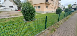
| − | File:OMIMG_20241003_125246.jpg|alt="paved footway to the right; fence with lawn and other footway behind"|… but you can easily walk there from the other side. | + | File:OMIMG_20241003_125246.jpg|alt="paved footway to the right; fence with lawn and other footway behind"|… but you can easily walk there from the other side. Oh, and there’s a 🇩🇪 German flag on the top right. |
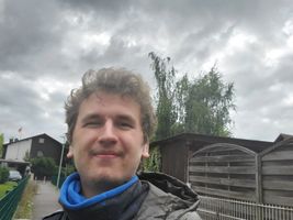
| − | File:OMIMG_20241003_125304.jpg|alt="selfie of myself, cloudy sky in the background"|I didn’t do the funny grin in a long time! | + | File:OMIMG_20241003_125304.jpg|alt="selfie of myself, cloudy sky in the background"|I didn’t do the funny grin in a long time! (Plus I did it in front of a flag!) |
</gallery> | </gallery> | ||
After that, we went for a walk in the west half of Jügesheim. Before arriving back at the car, we took a quick look at the evangelical ''Emmaus-Gemeinde Jügesheim'' (“Emmaus Congregation of Jügesheim”). | After that, we went for a walk in the west half of Jügesheim. Before arriving back at the car, we took a quick look at the evangelical ''Emmaus-Gemeinde Jügesheim'' (“Emmaus Congregation of Jügesheim”). | ||
| Line 77: | Line 74: | ||
== Achievements == | == Achievements == | ||
{{#vardefine:ribbonwidth|100%}} | {{#vardefine:ribbonwidth|100%}} | ||
| + | === First-time === | ||
| + | I earned these for the first time from this geohash. | ||
| + | {{Vexillology | ||
| + | | latitude = 50 | ||
| + | | longitude = 8 | ||
| + | | date = 2024-10-03 | ||
| + | | name = [[User:Green guy!|Green guy!]] | ||
| + | | image = OMIMG_20241003_125246.jpg | ||
| + | }} | ||
| + | (Does this still count, as I didn’t notice the flag on-site but captured it on photo anyway?) | ||
| + | |||
=== Recurring === | === Recurring === | ||
I already earned these from an earlier geohash, but fulfilled the conditions again on this one. | I already earned these from an earlier geohash, but fulfilled the conditions again on this one. | ||
| − | + | {{OpenStreetMap achievement | |
| − | | latitude = | + | | latitude = 50 |
| − | | longitude = | + | | longitude = 8 |
| − | | date = | + | | date = 2024-10-03 |
| − | | OSMlink = | + | | OSMlink = 157704786 |
| − | | OSMlink2 = | + | | OSMlink2 = 157706684 |
| − | |||
| name = [[User:Green guy!|Green guy!]] | | name = [[User:Green guy!|Green guy!]] | ||
| − | }} | + | }} |
{{Land geohash | {{Land geohash | ||
| latitude = 50 | | latitude = 50 | ||
Latest revision as of 08:39, 23 November 2024
| Thu 3 Oct 2024 in 50,8: 50.0237438, 8.8752049 geohashing.info google osm bing/os kml crox |
Location
In the residential area of Jügesheim (Rodgau), next to a foot-/cycleway, in Offenbach district, Hesse, Germany.
This day’s weather: mostly cloudy, 10–13 °C
Participants
- Green guy! (talk)
- Green guy!’s mother
- Green guy!’s father
Plans
- Drive to Jügesheim (Rodgau) in the noon
- Park our car nearby and go on a walk to visit the hashpoint (estimated hashpoint arrival at 12:50–13:10)
- Have lunch at Da Vinci Ristorante Gelateria
- Drive back home
Expedition
Reaching the coordinates and going for a walk
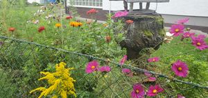
Upon arriving at Jügesheim, we entered the residential area from the west and quickly found a roadside parking space for our car. From there, we only had to walk a few meters to reach the coordinates. South of the hashpoint, you can see a flag of Germany on a roof.
After that, we went for a walk in the west half of Jügesheim. Before arriving back at the car, we took a quick look at the evangelical Emmaus-Gemeinde Jügesheim (“Emmaus Congregation of Jügesheim”).
Having lunch at the restaurant
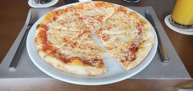
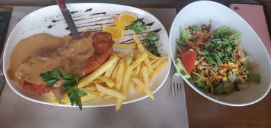
As planned, my parents and I drove to Da Vinci Ristorante Gelateria. Upon arriving there, my mother was immediately excited as the restaurant looked really classy, since I tend to choose quality eateries for geohashing expeditions. When the waiter brought the menu [it’s bilingual, both German and English], I showed the funny part about deliberately incorporated print errors
[correct translation would be misprints or typos] to my parents, causing delightful laughter.
The restaurant was so impressive to my mother that she asked me to compile this and other lovely eateries from our previous expeditions into a list, for visiting them in the context of future festivities.
After lunch
With our bellies being full, we went for another walk in the vicinity of the restaurant, visiting the Wasserturm (water tower) and the Waldfriedhof (forest cemetery) of Jügesheim on our way.
After that, I got myself an ice-cream cone with two tasty scoops of ice cream (cookies and dark chocolate, respectively) and ate it on our way back home.
Final verdict
Nice and easy, after a long geohashing pause!
From now on, expeditions will happen more sporadically as there are a lot of other interesting subject areas in my life that I want to invest time in, such as work (computer programming), music, and reading TV Tropes.
Tracklog: Two walks
- This tracklog is made of two segments (ignore the straight connection line between them):
- The southwest (bottom-left) loop shows our before-lunch walk to reach the coordinates.
- The northeast (top-right) loop shows our after-lunch walk.
- Direction: anti-clockwise for both loops
- GPS accuracy: good
- Markers show all locations where I took photos (including some photos taken separate from the tracklog) – one of them is taken for OpenStreetMap surveying and not uploaded here.
Achievements
First-time
I earned these for the first time from this geohash.
Green guy! earned the Vexillologist achievement
|
(Does this still count, as I didn’t notice the flag on-site but captured it on photo anyway?)
Recurring
I already earned these from an earlier geohash, but fulfilled the conditions again on this one.
Green guy! earned the OpenStreetMap achievement
|
Green guy! earned the Land geohash achievement
|
