Difference between revisions of "2023-06-01 40 -111"
From Geohashing
(typo) |
(→Photos) |
||
| (One intermediate revision by one other user not shown) | |||
| Line 20: | Line 20: | ||
2023-06-01 40 -111 Spot.jpg | Spot | 2023-06-01 40 -111 Spot.jpg | Spot | ||
2023-06-01 40 -111 Grin.jpg | Grin | 2023-06-01 40 -111 Grin.jpg | Grin | ||
| + | 2023-06-01 40 -111 gps.png | GPS | ||
</gallery> | </gallery> | ||
| Line 27: | Line 28: | ||
[[Category:Expeditions with photos]] | [[Category:Expeditions with photos]] | ||
[[Category:Coordinates reached]] | [[Category:Coordinates reached]] | ||
| + | {{location|US|UT|UT}} | ||
Latest revision as of 20:33, 27 December 2024

| Thu 1 Jun 2023 in 40,-111: 40.1007845, -111.6704596 geohashing.info google osm bing/os kml crox |
Location
Just off the trail on Spanish Fork River Trail land not far from Spanish Fork Sports Park
Participants
Plans
Go on a short hike with the family and check out the hash location.
Expedition
We found a parking spot not too far from the trail, and went on a short hike up and down the trail.
Photos
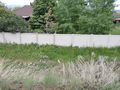
Spot

Grin
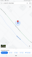
GPS

