Difference between revisions of "2024-12-27 1 103"
Frosetrain (talk | contribs) |
Frosetrain (talk | contribs) |
||
| (2 intermediate revisions by 2 users not shown) | |||
| Line 11: | Line 11: | ||
== Expedition == | == Expedition == | ||
| − | + | I did my OSINT/reconnaissance. The hash was in a very empty area in Mandai, beyond the end of a road leading to nowhere. The road was surrounded by a massive (for Singapore) area of grass, with a train+bus depot to the west and several military training areas to the east. There was not much information I could find about this particular road, except for a Google Maps location with pictures posted by someone just one week ago. That assured me that it was probably possible to reach the geohash. I also found out that the hill that the hash was on used to contain a quarry, which is now off-limits, and that there were plans to construct an underground bunker for construction materials under the patch of grass. | |
| + | |||
| + | I got to the geohash by public transport, taking four legs in total to get there (which was not the best route, I could have done it by two). I took the East-West Line and North-South Line to Choa Chu Kang, took the LRT to Phoenix, then took bus 170. I alighted at Da Di Glass, at the foot of Gali Batu Close, slightly after 3pm. From there I crossed the road and walked up Gali Batu Close, passing by the entrance to the Gali Batu train depot. The train depot was a “protected area”, with signs prohibiting photography and videography, so I had to quickly make my way past without seeming too sus. | ||
| + | |||
| + | [[File:2024-12-27_1_103_02.jpg|300px|thumb|center|green fence]] | ||
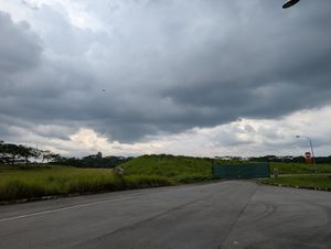
| + | A bit more walking led me to a fence across Gali Batu Close. Calling it a fence would be an overstatement, as it was just a few sheets of green corrugated iron blocking the road to stop cars from entering. I could just walk around it on the grass, and since there were no signs on the fence, I was hopefully not trespassing. | ||
| + | |||
| + | [[File:2024-12-27_1_103_04.jpg|300px|thumb|center|Road]] | ||
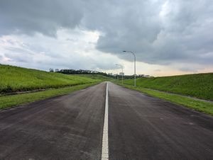
| + | On the road to nowhere I walked for 650 metres. This was the most isolated I have ever been, in terms of the distance to the nearest human. It was quiet, and empty, with wind in my ears, and a slight drizzle from the recent rain. The road had only the centre line, creating a two-way road, and there was a pavement on one side. Eventually I reached the roundabout at the end of the road. Typically, when new roads are constructed, like for MRT stations, a road ends in a roundabout before it is connected to other roads afterwards. According to the Master Plan, it seemed that this road would eventually lead to a grid of roads, maybe creating a new industrial area? Anyways, I continued walking on the grass, jumped a canal, and waddled through the grass. I eventually got to the geohash, which was in a muddier patch of grass. I took some photos and started walking back. | ||
| + | [[File:2024-12-27_1_103_08.jpg|300px|thumb|center|Reached]] | ||
| + | |||
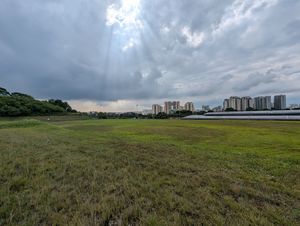
| + | On the way back, I went off the road at several points to observe the surroundings. The grassy area where I was in was surrounded by areas of higher elevation, in the military training areas, and I could barely identify fences with signs between this grass and the military area. There was a big flock of birds, and a random tractor/lawnmower/idk in the grass. Near the exit, where the fence was, I saw a guy jogging up the road, seemingly out for some exercise. I guess this place is slightly more known than I originally thought… Anyways, I walked out, walked past some SBS employees, and caught bus 160 to Jurong, then took the MRT home. | ||
== Tracklog == | == Tracklog == | ||
| Line 17: | Line 28: | ||
== Photos == | == Photos == | ||
| − | |||
| − | |||
| − | |||
<gallery perrow="5"> | <gallery perrow="5"> | ||
| + | Image:2024-12-27_1_103_01.jpg | helikopter helikopter (on the MRT) | ||
| + | Image:2024-12-27_1_103_02.jpg | green fence | ||
| + | Image:2024-12-27_1_103_03.jpg | Other side of the fence | ||
| + | Image:2024-12-27_1_103_04.jpg | Road (i walk a lonely road) | ||
| + | Image:2024-12-27_1_103_05.jpg | Bird | ||
| + | Image:2024-12-27_1_103_06.jpg | More birds | ||
| + | Image:2024-12-27_1_103_07.jpg | Look at this expanse | ||
| + | Image:2024-12-27_1_103_08.jpg | Sun rays | ||
| + | Image:2024-12-27_1_103_09.jpg | jumped a fence | ||
| + | Image:2024-12-27_1_103_10.jpg | The only tree in a 112m radius | ||
| + | Image:2024-12-27_1_103_11.jpg | The roundabout / u-turn area | ||
| + | Image:2024-12-27_1_103_12.jpg | Nice forest and clouds and fluffy grass | ||
| + | Image:2024-12-27_1_103_13.jpg | The hill and fluffy grass | ||
| + | Image:2024-12-27_1_103_14.jpg | Tractor and train depot | ||
| + | Image:2024-12-27_1_103_15.jpg | Sun, seen on the public bus | ||
| + | Image:2024-12-27_1_103_16.png | Geohash Droid | ||
</gallery> | </gallery> | ||
| Line 27: | Line 51: | ||
<!-- Add any achievement ribbons you earned below, or remove this section --> | <!-- Add any achievement ribbons you earned below, or remove this section --> | ||
| − | |||
| − | |||
| − | |||
| − | |||
[[Category:Expeditions]] | [[Category:Expeditions]] | ||
| − | |||
[[Category:Expeditions with photos]] | [[Category:Expeditions with photos]] | ||
| − | |||
| − | |||
| − | |||
| − | |||
[[Category:Coordinates reached]] | [[Category:Coordinates reached]] | ||
| − | + | {{location|SG|NW}} | |
| − | |||
| − | |||
| − | |||
| − | |||
| − | |||
| − | |||
| − | |||
| − | |||
| − | |||
| − | |||
| − | |||
| − | |||
Latest revision as of 01:49, 28 December 2024
| Fri 27 Dec 2024 in 1,103: 1.3966900, 103.7571063 geohashing.info google osm bing/os kml crox |
Location
Beyond the end of Gali Batu Close in Mandai
Participants
Plans
I'll take a bus to Da Di Glass at about 3pm, then walk up Gali Batu Close.
Expedition
I did my OSINT/reconnaissance. The hash was in a very empty area in Mandai, beyond the end of a road leading to nowhere. The road was surrounded by a massive (for Singapore) area of grass, with a train+bus depot to the west and several military training areas to the east. There was not much information I could find about this particular road, except for a Google Maps location with pictures posted by someone just one week ago. That assured me that it was probably possible to reach the geohash. I also found out that the hill that the hash was on used to contain a quarry, which is now off-limits, and that there were plans to construct an underground bunker for construction materials under the patch of grass.
I got to the geohash by public transport, taking four legs in total to get there (which was not the best route, I could have done it by two). I took the East-West Line and North-South Line to Choa Chu Kang, took the LRT to Phoenix, then took bus 170. I alighted at Da Di Glass, at the foot of Gali Batu Close, slightly after 3pm. From there I crossed the road and walked up Gali Batu Close, passing by the entrance to the Gali Batu train depot. The train depot was a “protected area”, with signs prohibiting photography and videography, so I had to quickly make my way past without seeming too sus.
A bit more walking led me to a fence across Gali Batu Close. Calling it a fence would be an overstatement, as it was just a few sheets of green corrugated iron blocking the road to stop cars from entering. I could just walk around it on the grass, and since there were no signs on the fence, I was hopefully not trespassing.
On the road to nowhere I walked for 650 metres. This was the most isolated I have ever been, in terms of the distance to the nearest human. It was quiet, and empty, with wind in my ears, and a slight drizzle from the recent rain. The road had only the centre line, creating a two-way road, and there was a pavement on one side. Eventually I reached the roundabout at the end of the road. Typically, when new roads are constructed, like for MRT stations, a road ends in a roundabout before it is connected to other roads afterwards. According to the Master Plan, it seemed that this road would eventually lead to a grid of roads, maybe creating a new industrial area? Anyways, I continued walking on the grass, jumped a canal, and waddled through the grass. I eventually got to the geohash, which was in a muddier patch of grass. I took some photos and started walking back.
On the way back, I went off the road at several points to observe the surroundings. The grassy area where I was in was surrounded by areas of higher elevation, in the military training areas, and I could barely identify fences with signs between this grass and the military area. There was a big flock of birds, and a random tractor/lawnmower/idk in the grass. Near the exit, where the fence was, I saw a guy jogging up the road, seemingly out for some exercise. I guess this place is slightly more known than I originally thought… Anyways, I walked out, walked past some SBS employees, and caught bus 160 to Jurong, then took the MRT home.


