Difference between revisions of "2008-07-27 37 -122"
From Geohashing
imported>Radii (→Photos) |
imported>FippeBot m (Location) |
||
| (One intermediate revision by one other user not shown) | |||
| Line 21: | Line 21: | ||
Image:Img_3149.jpg|Tomtom showing GPS coordinates | Image:Img_3149.jpg|Tomtom showing GPS coordinates | ||
</gallery> | </gallery> | ||
| + | |||
| + | [[Category:Expeditions]] | ||
| + | [[Category:Expeditions with photos]] | ||
| + | [[Category:Coordinates reached]] | ||
| + | {{location|US|CA|AA}} | ||
Latest revision as of 06:08, 7 August 2019
| Sun 27 Jul 2008 in San Francisco, California: 37.7862360, -122.1320234 geohashing.info google osm bing/os kml crox |
Logistics
About a mile along a fire road in Anthony Chabot Regional Park, then a hundred feet through moderately difficult brush down a Category 4 incline. Poison Oak present but not endemic.
Attendees
adi and three friends (A, B, and U) brought a picnic.
Photos
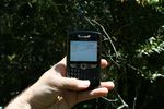
Blackberry showing GPS coordinates
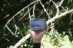
Tomtom showing GPS coordinates

