Difference between revisions of "2008-09-20 -19 146"
imported>Mattyk |
m (per Renaming Proposal) |
||
| (9 intermediate revisions by 4 users not shown) | |||
| Line 1: | Line 1: | ||
| − | {{ | + | {{meetup graticule |
| + | |map=<map lat="-19" lon="146" date="2008-09-20"/> | ||
| + | |lat=-19 | ||
| + | |lon=146 | ||
| + | |date=2008-09-20 | ||
| + | }} | ||
| + | {{Graticule unlocked | ||
|latitude=-19 | |latitude=-19 | ||
|longitude=146 | |longitude=146 | ||
| Line 6: | Line 12: | ||
|image=2008-09-02 -19 146.jpg | |image=2008-09-02 -19 146.jpg | ||
}} | }} | ||
| − | |||
| − | + | <div style="font-size:200%;font-family:serif;text-decoration:underline;margin-bottom:.5em;">[[Townsville, Australia]]</div> | |
| + | |||
| + | I set out with my intrepid partner (read: 2 year-old daughter) at around 1520. We sang nursery rhymes in the car, until she eventually fell asleep. | ||
| + | |||
| + | After around half an hour of driving, we reached the approximate location. I drove 25m or so along a ''"track"'' beside the railway line, and got out of the car to take some photos. | ||
| + | |||
| + | Due to lack of GPS, sextant, or even compass, I relied on my Google maps satellite view printout. Noting that the hash-point lies on the intersection of an imaginary line between the road-railway intersection and the westernmost shed, and the continuation of the westernmost driveway on the other side of the road, I triangulated its position to within approximately 5m. For want of something more precise, I chose a fence-post conveniently placed in my approximation zone as the official location. (Welcome to North Queensland, where near enough means you're trying too hard.) | ||
| + | |||
| + | Photography ensued: | ||
| + | |||
| + | [[Image:2008-09-02 -19 146.jpg|thumb|left|[[User:Mattyk|Matty]] with his map.]] | ||
| + | |||
| + | [[Image: 2008-09-20 -19 146 assistant.jpg|thumb|left|My intrepid assistant waiting in the car.]] | ||
| + | |||
| + | [[Image:2008-09-20 -19 146 pano.jpg|thumb|left|800px|Dodgy panorama taken on the "spot". ([http://geohashing.kerwin.net.au/2008-09-20/pictures.kml Load in Google Earth])]] | ||
| + | |||
| + | <div style="clear:both"></div> | ||
| + | |||
| + | Then we drove home. I had to overtake a five-segment road train on the way. | ||
| + | |||
| + | [[Image: 2008-09-20 -19 146 road-train.jpg|thumb|left|A large truck. Sorry no better view. (Read the yellow sign)]] | ||
| − | [[Category: Coordinates reached]] | + | [[Category:Expeditions]] |
| + | [[Category:Expeditions with photos]] | ||
| + | [[Category:Expedition without GPS]] | ||
| + | [[Category:Coordinates reached]] | ||
| + | {{location|AU|QLD|TV}} | ||
Latest revision as of 07:35, 20 March 2024
| Sat 20 Sep 2008 in -19,146: -19.5939233, 146.8365649 geohashing.info google osm bing/os kml crox |
Matty earned the Graticule Unlocked Achievement
|
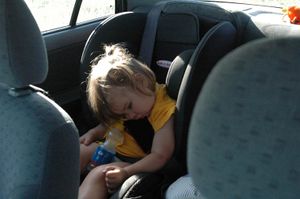
I set out with my intrepid partner (read: 2 year-old daughter) at around 1520. We sang nursery rhymes in the car, until she eventually fell asleep.
After around half an hour of driving, we reached the approximate location. I drove 25m or so along a "track" beside the railway line, and got out of the car to take some photos.
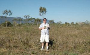
Due to lack of GPS, sextant, or even compass, I relied on my Google maps satellite view printout. Noting that the hash-point lies on the intersection of an imaginary line between the road-railway intersection and the westernmost shed, and the continuation of the westernmost driveway on the other side of the road, I triangulated its position to within approximately 5m. For want of something more precise, I chose a fence-post conveniently placed in my approximation zone as the official location. (Welcome to North Queensland, where near enough means you're trying too hard.)
Photography ensued:


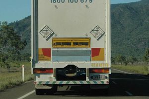
Then we drove home. I had to overtake a five-segment road train on the way.

