Difference between revisions of "2008-11-16 57 -3"
imported>Damianc |
imported>Fippe (Location) |
||
| (30 intermediate revisions by 4 users not shown) | |||
| Line 11: | Line 11: | ||
== About == | == About == | ||
| − | + | [[User:Smoulder|Smoulder]] and [[User:damianc|Damianc]] made this expedition. | |
| − | + | The geohash of the day was in the water somewhere in the north Moray Firth. | |
| − | We | + | We didn't have a boat so immediately realised that this would be a failed attempt. |
| − | + | We set the venue as the first point of landfall south of the geohash at 57.724098°, -3.350491° because this was just down the road for us. We set the additional goal for the geohash of stretching the boundaries of what "landfall" could mean by walking northwards into the sea. | |
| − | The | + | == The expedition == |
| − | + | We started at Covesea village, half a mile away from the proposed venue, which gave us a good view of our target. A path led us down to the beach through the caves and onto the cobbles. | |
| − | + | The water was breaking over Covesea Skerries and we took a bearing off the westward end of the westward skerry to pinpoint our location on the beach. | |
| − | |||
| − | |||
| − | |||
| − | + | The tide had just started to recede from the high water mark and the waves were more than ripples (to put it mildly), so we achieved little progress northwards. Smoulder walked as deep as she could in her wellies without getting water IN her wellies; Damianc got his feet wet. | |
| + | Smoulder is rather pleased that the water went no further than 1 centimetre from the top of her wellies. Damianc's feet survived his soggy monkey boots all the way back home to post this report. | ||
== Gallery == | == Gallery == | ||
<gallery> | <gallery> | ||
| − | Image:2008-11-16_elgin_grin_smoulder.jpg|[[2008-11-16 57 -3|Obligatory | + | Image:2008-11-16_57_-3_skerries.jpg|[[2008-11-16 57 -3|Breakers on the Skerries]] |
| + | Image:2008-11-16_57_-3_map.jpg|[[2008-11-16 57 -3|No GPS for us]] | ||
| + | Image:2008-11-16_57_-3_boat.jpg|[[2008-11-16 57 -3|Should we have hailed this boat?]] | ||
| + | Image:2008_11-16_57_-3_just_checking.jpg|[[2008-11-16 57 -3|Careful thought required]] | ||
| + | Image:2008-11-16_elgin_grin_failed.jpg|[[2008-11-16 57 -3|Obligatory grim [TM] - damianc]] | ||
| + | Image:2008-11-16_elgin_grin_smoulder.jpg|[[2008-11-16 57 -3|Obligatory grin [TM] - Smoulder]] | ||
| + | Image:2008-11-16_57_-3_wellies.jpg|[[2008-11-16 57 -3|Attempt to go north abandoned at depth]] | ||
| + | Image:2008-11-16_57_-3_msg.jpg|[[2008-11-16 57 -3|Left an ephemeral message]] | ||
</gallery> | </gallery> | ||
| Line 41: | Line 46: | ||
[[Category:Expedition without GPS]] | [[Category:Expedition without GPS]] | ||
[[Category:Coordinates not reached]] | [[Category:Coordinates not reached]] | ||
| − | [[Category: | + | [[Category:Not reached - Attended alternate location]] |
| + | {{location|GB|SCT}} | ||
Latest revision as of 17:36, 5 July 2019
| Sun 16 Nov 2008 in Elgin: 57.9874987, -3.3504907 geohashing.info google osm bing/os kml crox |
About
Smoulder and Damianc made this expedition.
The geohash of the day was in the water somewhere in the north Moray Firth.
We didn't have a boat so immediately realised that this would be a failed attempt.
We set the venue as the first point of landfall south of the geohash at 57.724098°, -3.350491° because this was just down the road for us. We set the additional goal for the geohash of stretching the boundaries of what "landfall" could mean by walking northwards into the sea.
The expedition
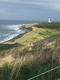
We started at Covesea village, half a mile away from the proposed venue, which gave us a good view of our target. A path led us down to the beach through the caves and onto the cobbles.
The water was breaking over Covesea Skerries and we took a bearing off the westward end of the westward skerry to pinpoint our location on the beach.
The tide had just started to recede from the high water mark and the waves were more than ripples (to put it mildly), so we achieved little progress northwards. Smoulder walked as deep as she could in her wellies without getting water IN her wellies; Damianc got his feet wet.
Smoulder is rather pleased that the water went no further than 1 centimetre from the top of her wellies. Damianc's feet survived his soggy monkey boots all the way back home to post this report.


