Difference between revisions of "2008-11-22 30 -98"
imported>S3g2 (→About) |
imported>FippeBot m (Location) |
||
| (2 intermediate revisions by one other user not shown) | |||
| Line 10: | Line 10: | ||
This is the 2nd known attempt at a hashpoint in the [[Fredericksburg, Texas]] graticule. It is located in Pace Bend park, which is surrounded by Lake Travis on three sides. The point was reached successfully, but my camera crapped out after a couple of pictures. | This is the 2nd known attempt at a hashpoint in the [[Fredericksburg, Texas]] graticule. It is located in Pace Bend park, which is surrounded by Lake Travis on three sides. The point was reached successfully, but my camera crapped out after a couple of pictures. | ||
| − | == Expedition == | + | == Expedition ([[User:s3g2|s3g2]])== |
The drive from Austin was not bad, and I reached the park, paid my entrance fee and parked near the trail head that is close to the turnoff for Kate's Cove and Johnson Cove. The weather was cloudy and the temperature a cool 50 F, which was no trouble at all. I walked down this trail for barely a quarter mile before realizing I'd need to cut into the woods to get closer. So this I did, and after 30 minutes of making my way through and around clusters of trees and doing the GPS dance I finally reached the point, which was in a small draw which was luckily not muddy. For some reason my digital camera only got a few shots off before deciding to crap out on me by not focusing on anything. So, I only had two shots that came out well. On the way out, I found a shortcut leading back to the road (instead of the trail) and then my vehicle. | The drive from Austin was not bad, and I reached the park, paid my entrance fee and parked near the trail head that is close to the turnoff for Kate's Cove and Johnson Cove. The weather was cloudy and the temperature a cool 50 F, which was no trouble at all. I walked down this trail for barely a quarter mile before realizing I'd need to cut into the woods to get closer. So this I did, and after 30 minutes of making my way through and around clusters of trees and doing the GPS dance I finally reached the point, which was in a small draw which was luckily not muddy. For some reason my digital camera only got a few shots off before deciding to crap out on me by not focusing on anything. So, I only had two shots that came out well. On the way out, I found a shortcut leading back to the road (instead of the trail) and then my vehicle. | ||
| Line 20: | Line 20: | ||
Image:2008-11-22_30_-98_draw.JPG|Some local scenery | Image:2008-11-22_30_-98_draw.JPG|Some local scenery | ||
</gallery> | </gallery> | ||
| + | [[Category:Expeditions]] | ||
| + | [[Category:Coordinates reached]] | ||
| + | [[Category:Expeditions with photos]] | ||
| + | {{location|US|TX|TV}} | ||
Latest revision as of 00:48, 8 August 2019
| Sat 22 Nov 2008 in Fredericksburg, Texas: 30.4655210, -98.0221575 geohashing.info google osm bing/os kml crox |
About
This is the 2nd known attempt at a hashpoint in the Fredericksburg, Texas graticule. It is located in Pace Bend park, which is surrounded by Lake Travis on three sides. The point was reached successfully, but my camera crapped out after a couple of pictures.
Expedition (s3g2)
The drive from Austin was not bad, and I reached the park, paid my entrance fee and parked near the trail head that is close to the turnoff for Kate's Cove and Johnson Cove. The weather was cloudy and the temperature a cool 50 F, which was no trouble at all. I walked down this trail for barely a quarter mile before realizing I'd need to cut into the woods to get closer. So this I did, and after 30 minutes of making my way through and around clusters of trees and doing the GPS dance I finally reached the point, which was in a small draw which was luckily not muddy. For some reason my digital camera only got a few shots off before deciding to crap out on me by not focusing on anything. So, I only had two shots that came out well. On the way out, I found a shortcut leading back to the road (instead of the trail) and then my vehicle.
Gallery
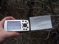
Le proof
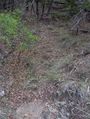
Some local scenery

