Difference between revisions of "2008-11-26 -36 174"
imported>Joannac m (on the sixth day of christmas) |
imported>FippeBot m (Location) |
||
| Line 22: | Line 22: | ||
[[Category:Expeditions with photos]] | [[Category:Expeditions with photos]] | ||
[[Category:Coordinates reached]] | [[Category:Coordinates reached]] | ||
| + | {{location|NZ|AUK}} | ||
Latest revision as of 00:51, 8 August 2019
| Wed 26 Nov 2008 in -36,174: -36.8994949, 174.7211041 geohashing.info google osm bing/os kml crox |
Aspirin had very little to do on a Wednesday afternoon until he found out the Geohash meet up point was nearby.
After checking #geohashing on irc.foonetic.net he realised nobody else was going, so he went by himself. To prove a point, he walked the whole way there (getting lost on the way because he didn't have a map apart from a very closely zoomed printout of the Geohash location). It took about 2 hours to walk there.
The hashpoint was on a very unassuming suburban property -- No.56 Parkinson Avenue, two doors down from the Pacific Islanders Presbyterian church. It was not really a very interesting area at all, but at least the Geohash was complete.
- On Location
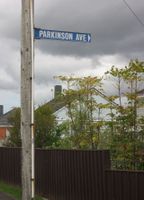
The Street
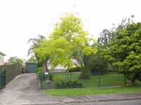
The Location (that small plant by the garage door would be where the hashpoint was)
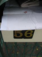
Left the printout of the hashpoint in their letterbox


