Difference between revisions of "2008-12-27 36 -78"
imported>Ncbears (→Achievements) |
imported>FippeBot m (Location) |
||
| (34 intermediate revisions by 2 users not shown) | |||
| Line 6: | Line 6: | ||
| date=2008-12-27 | | date=2008-12-27 | ||
}} | }} | ||
| + | ==Report== | ||
| + | Bear and Eisen ventured above Gaston Lake, stopping at a few geocaches along the way. Satellite recon via Google Earth proved less than accurate because we found the geohash point seemingly blocked with a row of new houses. Calls to Pope AFB and Norfolk Naval Base yielded no SR-71 flyovers to provide updated approach intel. But, fortunately, one lot to the side was still for sale, so we proceeded as if interested buyers, worked our way through the thorns to the elusive empty field in the rear, and found the 36 -78 geohash. Several deer paw prints suggested we were not the first to reach the location this day. | ||
| + | |||
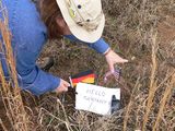
| + | Since Bear's kinfolk seem particularly active, we decided to do a little welcome from N36 W78. We use those small flags for baby Jurgen's grave. Jurgen was our 21 year old cat who passed away last March. | ||
| − | |||
==Participants== | ==Participants== | ||
| − | Bear | + | Eisen & Bear - [[User:Ncbears|NCBears]] |
| + | |||
| + | |||
| + | ==Geological Features== | ||
| + | Rolling farmland. Geohash in open field with low brush, grass, thorns. | ||
| + | |||
| + | ==Wildlife Encounters== | ||
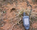
| + | Signs - White-tail deer prints (see picture below), domestic dog prints. | ||
| + | |||
| + | Sighting - Domestic dog across road from parking spot barked at us. | ||
| + | |||
| + | ==Weather== | ||
| + | 50°F/10°C, Overcast, Light wind | ||
| + | |||
| + | |||
| + | ==Pictures== | ||
| + | <gallery widths="160px" align=center> | ||
| + | Image:12_27_08_Geohashing_N36_W78.jpg|Hello distant kinfolk | ||
| + | Image:12_27_08_Geocaching_Deer_Paws_023.jpg|Missed deer meetup | ||
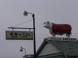
| + | Image:12_27_08_Geocaching_On_the_Way.jpg|Geomoo on the way | ||
| + | </gallery> | ||
==Achievements== | ==Achievements== | ||
<gallery widths="100px" align=center> | <gallery widths="100px" align=center> | ||
| − | Image:Cherry2.PNG[[Virgin Graticule]] | + | Image:Landgeohash.png|[[Land Geohash]] |
| + | Image:Cherry2.PNG|[[Virgin Graticule]] | ||
</gallery> | </gallery> | ||
| − | |||
| − | |||
| − | |||
| − | |||
[[Category:Expeditions]] | [[Category:Expeditions]] | ||
[[Category:Expeditions with photos]] | [[Category:Expeditions with photos]] | ||
[[Category:Coordinates reached]] | [[Category:Coordinates reached]] | ||
| + | {{location|US|VA|ME}} | ||
Latest revision as of 02:01, 6 August 2019
| Sat 27 Dec 2008 in 36,-78: 36.5988770, -78.0776342 geohashing.info google osm bing/os kml crox |
Report
Bear and Eisen ventured above Gaston Lake, stopping at a few geocaches along the way. Satellite recon via Google Earth proved less than accurate because we found the geohash point seemingly blocked with a row of new houses. Calls to Pope AFB and Norfolk Naval Base yielded no SR-71 flyovers to provide updated approach intel. But, fortunately, one lot to the side was still for sale, so we proceeded as if interested buyers, worked our way through the thorns to the elusive empty field in the rear, and found the 36 -78 geohash. Several deer paw prints suggested we were not the first to reach the location this day.
Since Bear's kinfolk seem particularly active, we decided to do a little welcome from N36 W78. We use those small flags for baby Jurgen's grave. Jurgen was our 21 year old cat who passed away last March.
Participants
Eisen & Bear - NCBears
Geological Features
Rolling farmland. Geohash in open field with low brush, grass, thorns.
Wildlife Encounters
Signs - White-tail deer prints (see picture below), domestic dog prints.
Sighting - Domestic dog across road from parking spot barked at us.
Weather
50°F/10°C, Overcast, Light wind


