Difference between revisions of "2009-01-10 48 12"
imported>Tomcat |
imported>FippeBot m (Location) |
||
| (15 intermediate revisions by 14 users not shown) | |||
| Line 41: | Line 41: | ||
[[Category:Coordinates reached]] | [[Category:Coordinates reached]] | ||
[[Category:Frozen geohash achievement]] | [[Category:Frozen geohash achievement]] | ||
| + | {{location|DE|BY|R}} | ||
Latest revision as of 01:20, 8 August 2019
| Sat 10 Jan 2009 in 48,12: 48.8659580, 12.2797711 geohashing.info google osm bing/os kml crox |
Tomcat
In the morning i realized, that again an alternative route to Munich, instead of the usual motorway, would lead me very close to todays hashpoint in the 48°N 12°E graticule. So i decided spontaneously to visit it, besides on that route there would some so far not visited Geocaches be within range.
When exploring the area on Google Earth i found out, that the hash was a few meters north of a very small river, named "Kleine (Small) Laber" - i happen to live also near a small river called "Laber", but some 30 km away - and was situated near the edge of a soccer field. Just as a joke, then i typed the coordinates of my origin geohash for that graticule and was more than only a bit surprised, to see that this point also was situated some meters north of a small river, that turned out to be named "Große (Great) Laber" and also happened to be next to the edge of another soccer field.
This rather unusual coincidence left no other choice for me, than visiting both points on my todays trip.
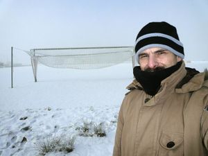
The trip itself started at about 10:00 at a temperature of -15° C at home, slowly rising to -12° C when approaching the first hashpoint the actual 2009-01-10_48_12. I reached the hashpoint at 11:10, just being in time to watch the sun breaking through the mist. Unfortunately i failed in documenting the actual temperature, because i relied only on my cars thermometer, that immediately began to climb after having my car parked near the hashpoint. Because of the low temperature i hurried to take a few photos at the hashpoint and left after some minutes, heading for the second intermediate stop - my displaced origin geohash at 48° 43,946' N, 12° 10,470' E.
Exactly at noon i reached the displaced origin hashpoint and again started the familiar procedure of taking photos of my GPSr, the environment of the point itself and me - this time with the need to show my identity card as a proof of having reached the proper location.
When i continued my trip to Munich, interrupted by some further stops at Geocaches, i wondered, how boring - but maybe faster - such trips had been in "former times", when no blinking, beeping, ringing and talking devices in the cockpit of my car tempted me permanently to interrupt my journey, to look for nameless and countless adventures beside the road.


