Difference between revisions of "2009-01-14 35 -77"
imported>Ncbears (→Report) |
imported>FippeBot m (Location) |
||
| (6 intermediate revisions by 2 users not shown) | |||
| Line 7: | Line 7: | ||
}} | }} | ||
==Report== | ==Report== | ||
| − | Finally, after a barren weekend we were glad to find a Geohash relatively close to home...and a [[Virgin_Graticule|Virgin Graticule]] to boot! The trip was relatively uneventful as we headed out right after work into the dark countryside south of Rocky Mount, NC. | + | Finally, after a barren weekend we were glad to find a Geohash relatively close to home...and a [[Virgin_Graticule|Virgin Graticule]] to boot! The trip was relatively uneventful as we headed out right after work into the dark countryside south of [[Greenville, North Carolina|Rocky Mount, NC]]. |
| − | We looked hard for a slushy/slirpy/squishy vendor..but to no avail. We could find ice cold carbonated beverage...but not the frozen part. | + | We looked hard for a slushy/slirpy/squishy vendor..but to no avail. We could find the ice cold carbonated beverage part...but not the frozen part. |
| − | The Geohash was located in a cornfield surrounded by | + | The Geohash was located in a cornfield surrounded by single-wide trailers. Fortunately, the ground had dried out and we did not have to trudge through mud. After a few photos we headed back north, passing the only sign of wild-life we encountered on the whole trip. |
==Participants== | ==Participants== | ||
| Line 19: | Line 19: | ||
==Geological Features== | ==Geological Features== | ||
| − | Level farmland. Outskirts of large town. Geohash was located ~17 meters | + | Level farmland. Outskirts of large town. Geohash was located ~17 meters into crop field. See Google Earth screenshot below. |
==Wildlife Encounters== | ==Wildlife Encounters== | ||
| Line 32: | Line 32: | ||
<gallery widths="160px" align=center> | <gallery widths="160px" align=center> | ||
Image:01_14_09_Geohash_005.jpg|NCBears at N35 W77 Geohash | Image:01_14_09_Geohash_005.jpg|NCBears at N35 W77 Geohash | ||
| − | Image:01_14_09_Geohash_006.jpg| | + | Image:01_14_09_Geohash_006.jpg|A dark field |
| − | Image:01_14_09_Walk_back_to_Truck_012.jpg| | + | Image:01_14_09_Walk_back_to_Truck_012.jpg|Walking back to the truck |
Image:01_14_09_Wild_life_near_Geohash_013.jpg|Sign of wild life near Geohash | Image:01_14_09_Wild_life_near_Geohash_013.jpg|Sign of wild life near Geohash | ||
Image:Goggle_Earth_Screenprint_01_14_09.JPG|Google Earth screenprint | Image:Goggle_Earth_Screenprint_01_14_09.JPG|Google Earth screenprint | ||
| Line 49: | Line 49: | ||
[[Category:Expeditions with photos]] | [[Category:Expeditions with photos]] | ||
[[Category:Coordinates reached]] | [[Category:Coordinates reached]] | ||
| + | {{location|US|NC|WO}} | ||
Latest revision as of 02:02, 6 August 2019
| Wed 14 Jan 2009 in 35,-77: 35.8578152, -77.8131697 geohashing.info google osm bing/os kml crox |
Report
Finally, after a barren weekend we were glad to find a Geohash relatively close to home...and a Virgin Graticule to boot! The trip was relatively uneventful as we headed out right after work into the dark countryside south of Rocky Mount, NC.
We looked hard for a slushy/slirpy/squishy vendor..but to no avail. We could find the ice cold carbonated beverage part...but not the frozen part.
The Geohash was located in a cornfield surrounded by single-wide trailers. Fortunately, the ground had dried out and we did not have to trudge through mud. After a few photos we headed back north, passing the only sign of wild-life we encountered on the whole trip.
Participants
Eisen & Bear - NCBears
Geological Features
Level farmland. Outskirts of large town. Geohash was located ~17 meters into crop field. See Google Earth screenshot below.
Wildlife Encounters
- See picture below of wild-life signs
Weather
33°F/0.6°C, clear skies
Pictures
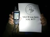
NCBears at N35 W77 Geohash

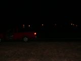
A dark field
Walking back to the truck

Sign of wild life near Geohash
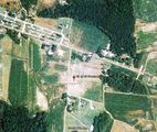
Google Earth screenprint


