Difference between revisions of "2009-02-01 43 -89"
imported>Starbird (photos for the first WOWhash, plus more reportage) |
imported>FippeBot m (Location) |
||
| Line 44: | Line 44: | ||
[[Category:Coordinates reached]] | [[Category:Coordinates reached]] | ||
[[Category:Walking on water geohash achievement]] | [[Category:Walking on water geohash achievement]] | ||
| + | {{location|US|WI|DA}} | ||
Latest revision as of 01:40, 8 August 2019
| Sun 1 Feb 2009 in Madison: 43.1038117, -89.3679656 geohashing.info google osm bing/os kml crox |
Participants
starbird
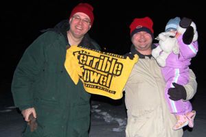
Bill Minser, wife Beth, and the Grouchy Toddler
Expedition
Our first non-Saturday geohash. We couldn't pass up an opportunity to combine a Frozen Geohash with a Water Geohash by walking on the surface of Lake Mendota. The point was just a few dozen yards offshore in a little bay in Maple Bluff.
The original plan was to hit this one in the mid-afternoon, because we all had plans to watch a minor American football game in the evening (GO STEELERS!). This didn't end up working out, time-wise. So we went to the Super Bowl party, telling ourselves that we would go hashing after the game if we had the energy.
After watching Pittsburgh win the game in the final minute, we decided we did have the energy, and set off to find the hash in the dark. It was just offshore of a residential neighborhood in the city, so it wasn't really dark. We found public access to the lake from nearby Burrows Park, and walked a couple of hundred meters on snow-covered ice to the hash point. Nobody fell in.
The Toddler had had a long day, and was not too pleased about blundering around in the dark (and cold), so after a couple of quick photos, we retreated to dry land and heated shelter.
That's a Terrible Towel in the photo. It's the traditional rally flag for the Pittsburgh Steelers.
This was the first ever Walking on water geohash.
starbird, Bill Minser, Beth, and the Grouchy Toddler earned the Walking on water geohash achievement
|
starbird, Bill Minser, Beth, and the Grouchy Toddler earned the Frozen Geohash Achievement
|

