Difference between revisions of "2009-05-19 28 -80"
imported>RFid (New page: {{subst:Expedition|lat=28|lon=-80|date=2009-05-18|image=Landgeohash.png}}) |
imported>FippeBot m (Location) |
||
| (14 intermediate revisions by 2 users not shown) | |||
| Line 1: | Line 1: | ||
| − | |||
<!-- If you did not specify these parameters in the template, please substitute appropriate things for IMAGE, LAT, LON, and DATE (YYYY-MM-DD format) --> | <!-- If you did not specify these parameters in the template, please substitute appropriate things for IMAGE, LAT, LON, and DATE (YYYY-MM-DD format) --> | ||
[[Image:Landgeohash.png|thumb|left]] | [[Image:Landgeohash.png|thumb|left]] | ||
| Line 5: | Line 4: | ||
| lat=28 | | lat=28 | ||
| lon=-80 | | lon=-80 | ||
| − | | date=2009-05- | + | | date=2009-05-19 |
}} | }} | ||
| Line 11: | Line 10: | ||
__NOTOC__ | __NOTOC__ | ||
== Participants == | == Participants == | ||
| + | * [[User:RFid|RFid]] Driver, Navigator and Photographer. | ||
| + | == Plans == | ||
| + | Plan? | ||
| − | + | No plan for this hash. Just jump in the car and off I go. | |
| + | Oops. Upon leaving the command bunker, it turns out that mother nature was trying to put me off with copious precipitation. Went back into the bunker and procured wet weather equipment. | ||
== Expedition == | == Expedition == | ||
| Line 20: | Line 23: | ||
== Tracklog == | == Tracklog == | ||
| + | No official GPS tracklog, but the route I took was rather convoluted. | ||
| + | Due to the rain, I decided to take the back roads from Merritt Island up to Titusville. 528 (Beachline) west to N. Courtenay Parkway. North on Courtenay through the North Merritt Island Nature Preserve to 405. West on 405 to South Street where the hash is located. | ||
| + | |||
| + | The route back was more direct since there was no rain. South Street and 405 to I95, then south on 95 to 528 East and back to Merritt Island. | ||
== Photos == | == Photos == | ||
| − | <gallery perrow=" | + | <gallery perrow="5"> |
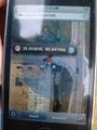
| − | Image: | + | Image:2009_5_19_28_80_00.jpg | route planning on the iPhone |
| − | Image: | + | Image:2009_5_19_28_80_01.jpg | sunny Florida! |
| + | Image:2009_5_19_28_80_02.jpg | draw bridge lifting up preventing progress | ||
| + | Image:2009_5_19_28_80_03.jpg | shuttle classroom at Astronaut Hall of Fame | ||
| + | Image:2009_5_19_28_80_04.jpg | iPhone trying to show I am there | ||
| + | Image:2009_5_19_28_80_05.jpg | marker morphed into a tree | ||
| + | Image:2009_5_19_28_80_06.jpg | mobile command center | ||
| + | Image:2009_5_19_28_80_07.jpg | view of the corner visible on the satellite image | ||
| + | Image:2009_5_19_28_80_08.jpg | positively chilly for Florida! | ||
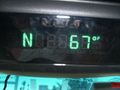
| + | Image:2009_5_19_28_80_09.jpg | tomtom showing satellite info | ||
</gallery> | </gallery> | ||
| Line 33: | Line 48: | ||
[[Category:Expedition planning]] | [[Category:Expedition planning]] | ||
--> | --> | ||
| + | == Achievements == | ||
| + | {{land geohash | ||
| + | |||
| + | | latitude = 28 | ||
| + | | longitude = -80 | ||
| + | | date = 2009-05-19 | ||
| + | | name = RFidd | ||
| + | | image = 2009_5_19_28_80_09.jpg | ||
| + | |||
| + | }} | ||
| + | {{Drowned rat geohash | ||
| + | |||
| + | | latitude = 28 | ||
| + | | longitude = -80 | ||
| + | | date = 2009-05-19 | ||
| + | | name = RFid | ||
| + | | reason = copious precipitation. First serious rain this year in Brevard County | ||
| + | | honourable = yes | ||
| + | |||
| + | }} | ||
| − | |||
| − | |||
| − | |||
[[Category:Expeditions]] | [[Category:Expeditions]] | ||
[[Category:Expeditions with photos]] | [[Category:Expeditions with photos]] | ||
| − | + | ||
| − | |||
| − | |||
| − | |||
| − | |||
[[Category:Coordinates reached]] | [[Category:Coordinates reached]] | ||
| − | + | {{location|US|FL|BE}} | |
| − | |||
| − | |||
| − | |||
| − | |||
| − | |||
| − | |||
| − | |||
| − | |||
| − | |||
Latest revision as of 02:27, 6 August 2019

| Tue 19 May 2009 in 28,-80: 28.5558392, -80.8474649 geohashing.info google osm bing/os kml crox |
Participants
- RFid Driver, Navigator and Photographer.
Plans
Plan?
No plan for this hash. Just jump in the car and off I go.
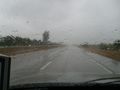
Oops. Upon leaving the command bunker, it turns out that mother nature was trying to put me off with copious precipitation. Went back into the bunker and procured wet weather equipment.
Expedition
Tracklog
No official GPS tracklog, but the route I took was rather convoluted.
Due to the rain, I decided to take the back roads from Merritt Island up to Titusville. 528 (Beachline) west to N. Courtenay Parkway. North on Courtenay through the North Merritt Island Nature Preserve to 405. West on 405 to South Street where the hash is located.
The route back was more direct since there was no rain. South Street and 405 to I95, then south on 95 to 528 East and back to Merritt Island.
Photos
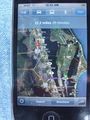
route planning on the iPhone
sunny Florida!
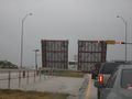
draw bridge lifting up preventing progress
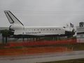
shuttle classroom at Astronaut Hall of Fame
iPhone trying to show I am there
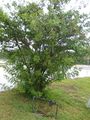
marker morphed into a tree

mobile command center
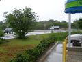
view of the corner visible on the satellite image
positively chilly for Florida!
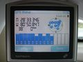
tomtom showing satellite info


Achievements
RFidd earned the Land geohash achievement
|
RFid earned the Drowned Rat Geohash Honourable Mention
|