Difference between revisions of "2009-05-30 50 -1"
imported>Sermoa (→Tracklog) |
imported>FippeBot m (Location) |
||
| (11 intermediate revisions by one other user not shown) | |||
| Line 9: | Line 9: | ||
<!-- edit as necessary --> | <!-- edit as necessary --> | ||
__NOTOC__ | __NOTOC__ | ||
| + | == About == | ||
| + | |||
| + | The geohash was at Kensington Road in Gosport. | ||
| + | |||
== Participants == | == Participants == | ||
| Line 30: | Line 34: | ||
<gallery perrow="3"> | <gallery perrow="3"> | ||
| − | Image:2009- | + | Image:2009-05-30_50_-1_route.jpg | The route from Gosport Ferry to the location. |
| − | Image:2009- | + | Image:2009-05-30_50_-1_location.jpg | Location of the geohash, as found by the lookup tool. |
| + | Image:2009-05-30_50_-1_note.jpg | A note i posted through the door of the house to let them know about geohashing. | ||
| + | Image:2009-05-30_50_-1_conservatory.jpg | There's the actual conservatory where the geohash landed! | ||
| + | Image:2009-05-30_50_-1_road.jpg | Kensington Road. | ||
| + | Image:2009-05-30_50_-1_ferry.jpg | On the ferry to get to Gosport - that's the other one returning. | ||
</gallery> | </gallery> | ||
| − | + | === Panoramic photos === | |
| − | + | ||
| − | + | I took some photos in May in the hope of making a panorama. It's only now in October that i know how to do it! Unfortunately the photos don't overlap well enough to make a full 360 but i managed to get these little snippets. -- [[User:Sermoa|sermoa]] 18:19, 25 October 2009 (UTC) | |
| − | -- | + | |
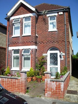
| + | [[Image:2009-05-30_50_-1_panorama1.jpg | thumb | left | 800px | From the end of the road, looking at the geohash house ]] | ||
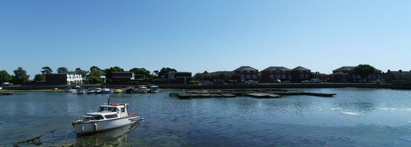
| + | [[Image:2009-05-30_50_-1_panorama2.jpg | thumb | left | 800px | The view of the water at the end of the road ]] | ||
| + | |||
| + | == Achievements == | ||
| + | |||
| + | It was my first geohash so i'll award myself this: | ||
| + | |||
| + | {{land geohash | ||
| + | |||
| + | | latitude = 50 | ||
| + | | longitude = -1 | ||
| + | | date = 2009-05-30 | ||
| + | | name = Sermoa | ||
| + | |||
| + | }} | ||
| + | |||
| + | Public transport is pretty much default for me anyway, since i don't have a car! But it was great to be able to go by ferry! :) | ||
| + | |||
| + | {{Public transport geohash | ||
| + | |||
| + | | latitude = 50 | ||
| + | | longitude = -1 | ||
| + | | date = 2009-05-30 | ||
| + | | busline = train and ferry | ||
| + | | name = Sermoa | ||
| + | | image = 2009-05-30_50_-1_ferry.jpg | ||
| + | |||
| + | }} | ||
| + | |||
| + | It was good fun even though i didn't meet anybody. I'll certainly do another one when it's somewhere i can get to. | ||
| − | |||
| − | |||
| − | |||
[[Category:Expeditions]] | [[Category:Expeditions]] | ||
[[Category:Expeditions with photos]] | [[Category:Expeditions with photos]] | ||
| − | |||
[[Category:Expedition without GPS]] | [[Category:Expedition without GPS]] | ||
| − | |||
| − | |||
| − | |||
[[Category:Coordinates reached]] | [[Category:Coordinates reached]] | ||
| − | + | {{location|GB|ENG|HAM}} | |
| − | |||
| − | |||
| − | |||
| − | |||
| − | |||
| − | |||
| − | |||
| − | |||
| − | |||
Latest revision as of 03:38, 8 August 2019
| Sat 30 May 2009 in 50,-1: 50.7907899, -1.1342739 geohashing.info google osm bing/os kml crox |
About
The geohash was at Kensington Road in Gosport.
Participants
Sadly just Sermoa. A lot of people were there by coincidence (because they happen to live in the area!) but i was the only person there by intention.
Expedition
I took the train from Winchester to Portsmouth Harbour, then the ferry over to Gosport. From there i walked to the coordinate location.
Tracklog
I'm not very good at geography, i didn't look at the map properly, i forgot the name of the road, and i forgot to take my phone so i didn't know the exact time.
Despite all those potential setbacks, i managed to find my way there. I roughly knew the time - i was there from about 15:50 to 16:20.
I took lots of photos and wrote a little note which i posted through the door of the house. I didn't have the nerve to knock and tell them about it. They probably would not have understood anyway!
Photos
Panoramic photos
I took some photos in May in the hope of making a panorama. It's only now in October that i know how to do it! Unfortunately the photos don't overlap well enough to make a full 360 but i managed to get these little snippets. -- sermoa 18:19, 25 October 2009 (UTC)
Achievements
It was my first geohash so i'll award myself this:
Sermoa earned the Land geohash achievement
|
Public transport is pretty much default for me anyway, since i don't have a car! But it was great to be able to go by ferry! :)
Sermoa earned the Public transport geohash achievement
|
It was good fun even though i didn't meet anybody. I'll certainly do another one when it's somewhere i can get to.


