Difference between revisions of "2009-05-29 33 -84"
(New page: {{meetup graticule | map=<map lat="33" lon="-84" date="2009-05-29" /> | lat=33 | lon=-84 | date=2009-05-29 | graticule_name=Atlanta | graticule_link=Atlanta, Georgia }} == Graticule == ...) |
imported>FippeBot m (Location) |
||
| (11 intermediate revisions by one other user not shown) | |||
| Line 14: | Line 14: | ||
== About == | == About == | ||
| + | This Geohash point ended up near a state park. I was hoping that the hash point would end up in the state park but looked too close to a road to be a part of the park. | ||
| + | |||
| + | On my way to the hash point I did drive through the park but only went so far in because a daily parking fee of $3 was required and I was only going to be there for 10 minutes or less. | ||
== Expedition == | == Expedition == | ||
=== [[User:NWoodruff|NWoodruff]] === | === [[User:NWoodruff|NWoodruff]] === | ||
| + | |||
| + | As I was driving down the dirt road to the nearest access to a public road, I came to a turn around point with 2 signs warning of private property beyond that point. I sat there thinking for about 5 minutes of what I should do. I thought about walking down the rest of the dirt road to the house on the property but didn't know how far down the road it was going to be. I stood at the edge of the road with 0.2 miles to the hash point. | ||
| + | |||
| + | I turned around and walked back to my truck. As I was reaching for my key to the truck, I saw off in the distance two cars coming from the private property. I waved to the first car and they stopped. It was a man and a woman my age in the car. I quickly explained geohasing to them and told them that I was looking to reach a point about 500 yards into the woods on their property. I asked if they had any problem with that. | ||
| + | |||
| + | They told me that they were late for a High School graduation and neither of them would mind as long as I was only going to walk into the woods. Permission granted!! I forgot to ask for their names as proof but instead at the last second took a picture of the two cars as they drove off as kind of proof of permission. | ||
| + | |||
| + | The first 20 feet into the woods was thick brush and I was attacked by the Raptors. It was up and down the entire way there. I eventually had to jump a small river that looked real pretty to me. | ||
| + | |||
| + | I eventually found the hash point with 0.00 feet to go. I took a few pictures and returned to my truck. | ||
| + | |||
| + | I then drove home to Norcross, through Atlanta. | ||
== Gallery == | == Gallery == | ||
<gallery caption="Photo Gallery" widths="200px" heights="200px" perrow="3"> | <gallery caption="Photo Gallery" widths="200px" heights="200px" perrow="3"> | ||
| − | Image:2009052933-84NW01.JPG| | + | Image:2009052933-84NW01.JPG| I was worried about this hash being on private property. I was correct. |
| + | Image:2009052933-84NW02.JPG| The hash point is 500 yards in that direction into the private property. | ||
| + | Image:2009052933-84NW03.JPG| Just as I was about to leave with a No Trespassing award, the owners of the property drove up. PERMISSION GRANTED! | ||
| + | Image:2009052933-84NW04.JPG| A stream that I had to jump across. | ||
| + | Image:2009052933-84NW05.JPG| 0.00 Feet to go. The exact location! | ||
| + | Image:2009052933-84NW06.JPG| Me at the exact location. | ||
| + | Image:2009052933-84NW07.JPG| My truck is 500 yards in that direction | ||
| + | Image:2009052933-84NW08.JPG| Looking East into Atlanta proper. | ||
</gallery> | </gallery> | ||
| Line 31: | Line 53: | ||
[[Category:Expeditions]] | [[Category:Expeditions]] | ||
[[Category:Coordinates reached]] | [[Category:Coordinates reached]] | ||
| + | {{location|US|GA|DL}} | ||
Latest revision as of 03:35, 8 August 2019
| Fri 29 May 2009 in Atlanta: 33.7427980, -84.6378794 geohashing.info google osm bing/os kml crox |
Graticule
About
This Geohash point ended up near a state park. I was hoping that the hash point would end up in the state park but looked too close to a road to be a part of the park.
On my way to the hash point I did drive through the park but only went so far in because a daily parking fee of $3 was required and I was only going to be there for 10 minutes or less.
Expedition
NWoodruff
As I was driving down the dirt road to the nearest access to a public road, I came to a turn around point with 2 signs warning of private property beyond that point. I sat there thinking for about 5 minutes of what I should do. I thought about walking down the rest of the dirt road to the house on the property but didn't know how far down the road it was going to be. I stood at the edge of the road with 0.2 miles to the hash point.
I turned around and walked back to my truck. As I was reaching for my key to the truck, I saw off in the distance two cars coming from the private property. I waved to the first car and they stopped. It was a man and a woman my age in the car. I quickly explained geohasing to them and told them that I was looking to reach a point about 500 yards into the woods on their property. I asked if they had any problem with that.
They told me that they were late for a High School graduation and neither of them would mind as long as I was only going to walk into the woods. Permission granted!! I forgot to ask for their names as proof but instead at the last second took a picture of the two cars as they drove off as kind of proof of permission.
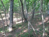
The first 20 feet into the woods was thick brush and I was attacked by the Raptors. It was up and down the entire way there. I eventually had to jump a small river that looked real pretty to me.
I eventually found the hash point with 0.00 feet to go. I took a few pictures and returned to my truck.
I then drove home to Norcross, through Atlanta.
Gallery
- Photo Gallery
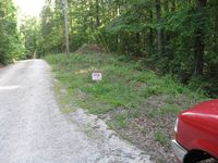
I was worried about this hash being on private property. I was correct.
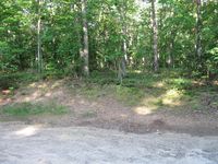
The hash point is 500 yards in that direction into the private property.
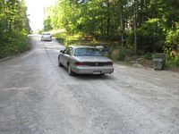
Just as I was about to leave with a No Trespassing award, the owners of the property drove up. PERMISSION GRANTED!
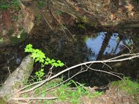
A stream that I had to jump across.
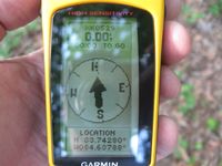
0.00 Feet to go. The exact location!
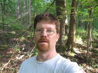
Me at the exact location.
My truck is 500 yards in that direction
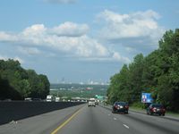
Looking East into Atlanta proper.


Achievements
NWoodruff earned the Land geohash achievement
|