Difference between revisions of "2009-06-11 33 -84"
From Geohashing
(New page: {{meetup graticule | map=<map lat="33" lon="-84" date="2009-06-11" /> | lat=33 | lon=-84 | date=2009-06-11 | graticule_name=Atlanta | graticule_link=Atlanta, Georgia }} == Graticule == ...) |
imported>FippeBot m (Location) |
||
| (4 intermediate revisions by one other user not shown) | |||
| Line 24: | Line 24: | ||
<gallery caption="Photo Gallery" widths="200px" heights="200px" perrow="3"> | <gallery caption="Photo Gallery" widths="200px" heights="200px" perrow="3"> | ||
| − | Image:2009061133-84NW01.JPG| | + | Image:2009061133-84NW01.JPG| 69 feet to go onto a major road. |
| − | + | Image:2009061133-84NW02.JPG| 0.00 feet to go. The exact spot. | |
| + | Image:2009061133-84NW03.JPG| The actual Geohash spot. No marker here. There wasn't enough time between cars zooming past to leave anything. | ||
| + | Image:2009061133-84NW04.JPG| Me at the hash spot. | ||
</gallery> | </gallery> | ||
| Line 36: | Line 38: | ||
[[Category:Coordinates reached]] | [[Category:Coordinates reached]] | ||
[[Category:Expeditions with photos]] | [[Category:Expeditions with photos]] | ||
| + | {{location|US|GA|FU}} | ||
Latest revision as of 03:51, 8 August 2019
| Thu 11 Jun 2009 in Atlanta: 33.7887655, -84.4993303 geohashing.info google osm bing/os kml crox |
Graticule
About
Expedition
NWoodruff
The hash point ended up being right off the median in the center of the road. I reached it with 0.00 feet to go. Google maps has the hash point in the center of the south bound lane. I was worried that I would not be able to get to the actual hash point for the traffic in the 6pm rush hour. I did get a few cars and one large truck to honk at me as I was trying to get to 0.00 feet.
Gallery
- Photo Gallery
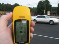
69 feet to go onto a major road.
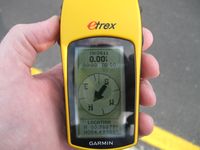
0.00 feet to go. The exact spot.
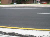
The actual Geohash spot. No marker here. There wasn't enough time between cars zooming past to leave anything.

Me at the hash spot.


Achievements
NWoodruff earned the Land geohash achievement
|