Difference between revisions of "2009-07-05 51 -4"
imported>Homsar (creating page) |
m (Location correction) |
||
| (4 intermediate revisions by 3 users not shown) | |||
| Line 1: | Line 1: | ||
| − | |||
| − | |||
| − | |||
| − | |||
| − | |||
{{meetup graticule | {{meetup graticule | ||
| lat=51 | | lat=51 | ||
| Line 10: | Line 5: | ||
}} | }} | ||
| − | |||
__NOTOC__ | __NOTOC__ | ||
| − | |||
| − | |||
== Participants == | == Participants == | ||
| + | : Just [[User:Homsar|me]] | ||
| + | == Expedition == | ||
| + | Today was the day of the Gower Bike Ride, an annual event where thousands of cyclist cycle around the [[wikipedia:Gower|Gower peninsula]] in aid of the [[wikipedia:British Heart Foundation|British Heart Foundation]]. Since this meant that lots of cyclists would be going around wearing red T-shirts with paper numbers on their back, I thought I'd blend in with a red ([[wikipedia:G&D's|G&D's]]) T-shirt and a piece of paper reading 'xkcd'. | ||
| − | + | Set off just before 4 in moderate rain. It brightened up after I reached the cycle track I was taking. Reached the end of that and started exploring new territory. Through some narrow side-roads (and under the dinkiest bridge you'll ever see - only 6'3" clearance, going under the rail line to West Wales I think), reached within 200m of the hashpoint (just after 4:30) but was stopped by the entrance gate to a steelworks (eerily quiet) and a fence blocking access to the presumed farmland that the hashpoint seemed to be on. | |
| − | |||
| − | |||
| − | |||
| + | Turned around, and headed back, taking some photos along the way. Was stopped by some folks drinking outside a pub who asked how long I'd taken; I confused them when I said I hadn't done it and that I'd tried to reach a random point picked by the internet. They wondered why I hadn't climbed over the fence. It started to rain again just as I reached the home stretch. | ||
== Tracklog == | == Tracklog == | ||
| − | + | Approximate map since OpenStreetMap doesn't yet cover Waunarlwydd fully. That's a project for when I get a GPS receiver! | |
| + | [[Image:2009-07-05 51 -4 tracklog.png]] | ||
== Photos == | == Photos == | ||
| − | + | (To follow once I get the Bluetooth working) | |
<gallery perrow="3"> | <gallery perrow="3"> | ||
| − | Image:2009- | + | Image:2009-07-05 51 -4 Map.jpg | The map showing the hashpoint and my position; hashpoint was somewhere in the background, probably above the frame of the shot |
| − | Image:2009- | + | Image:2009-07-05 51 -4 Fence.jpg | Fence prevented access to the hashpoint :-( |
| + | Image:2009-07-05 51 -4 Gate.JPG | Gate prevented me carrying on along the footpath | ||
| + | Image:2009-07-05 51 -4 Bridge 1.JPG | Tiniest bridge you ever saw! Forward approach… | ||
| + | Image:2009-07-05 51 -4 Bridge 2.jpg | …inside… | ||
| + | Image:2009-07-05 51 -4 Bridge 3.jpg | reverse approach | ||
| + | Image:2009-07-05 51 -4 Back.jpg | The (not-terribly-) infamous xkcd sign (in trademark Lucida Sans) | ||
| + | Image:2009-07-05 51 -4 Portrait.jpg | Me on my return, slightly wet. | ||
</gallery> | </gallery> | ||
| − | |||
| − | |||
| − | |||
| − | |||
| − | |||
| − | |||
| − | |||
[[Category:Expeditions]] | [[Category:Expeditions]] | ||
| − | |||
| − | |||
[[Category:Expedition without GPS]] | [[Category:Expedition without GPS]] | ||
| − | + | [[Category:Not reached - No public access]] | |
| − | |||
| − | |||
| − | [[Category: | ||
| − | |||
| − | |||
| − | |||
[[Category:Coordinates not reached]] | [[Category:Coordinates not reached]] | ||
| − | + | {{location|GB|CYM|ATA}} | |
| − | |||
| − | |||
| − | |||
| − | |||
| − | |||
Latest revision as of 11:49, 25 October 2020
| Sun 5 Jul 2009 in 51,-4: 51.3518423, -4.1062209 geohashing.info google osm bing/os kml crox |
Participants
- Just me
Expedition
Today was the day of the Gower Bike Ride, an annual event where thousands of cyclist cycle around the Gower peninsula in aid of the British Heart Foundation. Since this meant that lots of cyclists would be going around wearing red T-shirts with paper numbers on their back, I thought I'd blend in with a red (G&D's) T-shirt and a piece of paper reading 'xkcd'.
Set off just before 4 in moderate rain. It brightened up after I reached the cycle track I was taking. Reached the end of that and started exploring new territory. Through some narrow side-roads (and under the dinkiest bridge you'll ever see - only 6'3" clearance, going under the rail line to West Wales I think), reached within 200m of the hashpoint (just after 4:30) but was stopped by the entrance gate to a steelworks (eerily quiet) and a fence blocking access to the presumed farmland that the hashpoint seemed to be on.
Turned around, and headed back, taking some photos along the way. Was stopped by some folks drinking outside a pub who asked how long I'd taken; I confused them when I said I hadn't done it and that I'd tried to reach a random point picked by the internet. They wondered why I hadn't climbed over the fence. It started to rain again just as I reached the home stretch.
Tracklog
Approximate map since OpenStreetMap doesn't yet cover Waunarlwydd fully. That's a project for when I get a GPS receiver!

Photos
(To follow once I get the Bluetooth working)
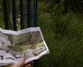
The map showing the hashpoint and my position; hashpoint was somewhere in the background, probably above the frame of the shot
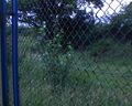
Fence prevented access to the hashpoint :-(
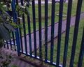
Gate prevented me carrying on along the footpath
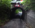
Tiniest bridge you ever saw! Forward approach…
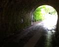
…inside…
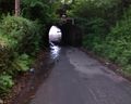
reverse approach
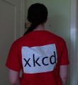
The (not-terribly-) infamous xkcd sign (in trademark Lucida Sans)

Me on my return, slightly wet.


