Difference between revisions of "2009-07-19 45 -123"
From Geohashing
imported>Jiml m (Start Planning) |
imported>FippeBot m (Location) |
||
| (5 intermediate revisions by one other user not shown) | |||
| Line 1: | Line 1: | ||
| − | |||
| − | |||
| − | |||
| − | |||
{{meetup graticule | {{meetup graticule | ||
| lat=45 | | lat=45 | ||
| Line 12: | Line 8: | ||
== Location == | == Location == | ||
South of Gaston, Oregon | South of Gaston, Oregon | ||
| + | |||
| + | The hashpoint was located at the edge of a active grain field. | ||
== Participants == | == Participants == | ||
| − | [[User:Jiml]] | + | [[User:Jiml|Jim]] |
== Plans == | == Plans == | ||
| Line 20: | Line 18: | ||
| − | |||
| − | |||
| + | == Expedition == | ||
| + | |||
| + | I went. I found the field. I found the farmer owning the field. I wandered out into | ||
| + | the field, dodging irrigation equipment. I found the ditch that feeds the irrigation | ||
| + | equipment. So did the Algorithm. | ||
| + | |||
| + | I think I need a boat. | ||
| + | |||
| + | More info to follow. And news of successful geocaching. | ||
| − | == | + | ==Consolation prize== |
| + | {{My kingdom for a boat | ||
| + | | latitude=45 | ||
| + | | longitude=-123 | ||
| + | | date=2009-07-19 | ||
| + | | name = [[User:Jiml|Jim]] | ||
| + | | waterhazard = irrigation ditch | ||
| + | }} | ||
| − | |||
| Line 33: | Line 44: | ||
<gallery perrow="3"> | <gallery perrow="3"> | ||
| − | Image:2009- | + | Image:2009-07-19_45_-123-ToFarmHouse2.jpg | Towards the farmhouse to ask for permission |
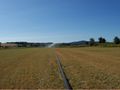
| − | Image:2009- | + | Image:2009-07-19_45_-123-ToHashpoint.jpg | View of the Hashpoint |
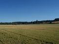
| + | Image:2009-07-19_45_-123-Valley2.jpg | Overview of the Valley | ||
| + | Image:2009-07-19_45_-123-IrrigDitch.jpg | View towards the water protected Hashpoint | ||
| + | Image:2009-07-19_45_-123-IrrigPipe.jpg | The irrigation equipment would run me over if I waited. | ||
| + | Image:2009-07-19_45_-123-FieldIrrigHead.jpg | View of the Irrigation equipment | ||
| + | |||
</gallery> | </gallery> | ||
| − | |||
| − | |||
| − | |||
| − | |||
| − | |||
| − | |||
| − | |||
| − | |||
[[Category:Expeditions]] | [[Category:Expeditions]] | ||
[[Category:Expeditions with photos]] | [[Category:Expeditions with photos]] | ||
| − | |||
| − | |||
| − | |||
| − | |||
| − | |||
| − | |||
| − | |||
| − | |||
| − | |||
[[Category:Coordinates not reached]] | [[Category:Coordinates not reached]] | ||
| − | |||
[[Category:Not reached - Mother Nature]] | [[Category:Not reached - Mother Nature]] | ||
| − | + | {{location|US|OR|YA}} | |
| − | |||
| − | |||
| − | |||
| − | |||
| − | |||
Latest revision as of 04:37, 8 August 2019
| Sun 19 Jul 2009 in 45,-123: 45.4147334, -123.1256176 geohashing.info google osm bing/os kml crox |
Location
South of Gaston, Oregon
The hashpoint was located at the edge of a active grain field.
Participants
Plans
I'm going to head to the hashpoint, and see what I find. - Jim
Expedition
I went. I found the field. I found the farmer owning the field. I wandered out into the field, dodging irrigation equipment. I found the ditch that feeds the irrigation equipment. So did the Algorithm.
I think I need a boat.
More info to follow. And news of successful geocaching.
Consolation prize
Jim earned the My kingdom for a boat consolation prize
|
Photos
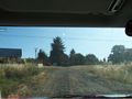
Towards the farmhouse to ask for permission
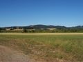
View of the Hashpoint
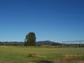
Overview of the Valley
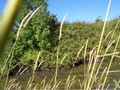
View towards the water protected Hashpoint
The irrigation equipment would run me over if I waited.
View of the Irrigation equipment


