Difference between revisions of "2009-08-06 41 -70"
From Geohashing
imported>Sara m (Should have written a limerick so I could say "There once was a hash near Nantucket...") |
m (per Renaming Proposal) |
||
| (One intermediate revision by one other user not shown) | |||
| Line 43: | Line 43: | ||
Drove back to Springfield. | Drove back to Springfield. | ||
| − | {{ | + | {{Graticule unlocked |
| latitude = 41 | | latitude = 41 | ||
| longitude = -70 | | longitude = -70 | ||
| Line 61: | Line 61: | ||
[[Category:Expeditions with photos]] | [[Category:Expeditions with photos]] | ||
[[Category:Coordinates reached]] | [[Category:Coordinates reached]] | ||
| + | {{location|US|MA|PL}} | ||
Latest revision as of 06:26, 20 March 2024

| Thu 6 Aug 2009 in 41,-70: 41.9224046, -70.7456359 geohashing.info google osm bing/os kml crox |
Location
In the middle of a residential street in Plymouth, Massachusetts.
Participants
Planning
Good Cape Cod hashpoint
And I'm nearby - in Cambridge --
Devirginalize!
The challenging part:
I'm scared to drive in Boston --
Wait 'til Rush Hour's done.
Expedition
Rare sight on xway:
An Alaska license plate!
(Pic came out blurry.)
Drove about an hour
To quiet suburban street:
Peter Road, Plymouth
Crickets chirp, tall trees
GPS dance with flashlight
Smells of evergreen
Marked the road with chalk.
Psyched about cherry ribbon,
Drove back to Springfield.
Sara earned the Graticule Unlocked Achievement
|
Photos
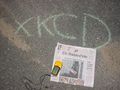
The marker on the pavement

The GPS
