Difference between revisions of "2009-09-21 46 5"
From Geohashing
imported>Crox |
imported>FippeBot m (Location) |
||
| (4 intermediate revisions by one other user not shown) | |||
| Line 6: | Line 6: | ||
}} | }} | ||
| − | == | + | == Location == |
| − | + | Le Planet, near Grand Crêt in [http://www.monts-jura.com/ Monts Jura] ; about 1550 m high. | |
| − | == | + | |
| + | ==Participants== | ||
| + | *[[user:Crox|Crox]] | ||
| + | *[[User:Elisa|Elisa]] | ||
| + | |||
| + | ==Expedition== | ||
Car was left a little under 3 km from the hash (and 650 m lower). It took us about 2.5 h to get to the hash. After a short break that will qualify Elisa for the picnic achievement, it took us another two hours to get back to the car. | Car was left a little under 3 km from the hash (and 650 m lower). It took us about 2.5 h to get to the hash. After a short break that will qualify Elisa for the picnic achievement, it took us another two hours to get back to the car. | ||
| Line 23: | Line 28: | ||
* the darkness on the way back did not help of course | * the darkness on the way back did not help of course | ||
| − | + | <gallery> | |
| + | Image:2009-09-21_46_5_01-ready.jpg|Ready to head to the hash | ||
| + | Image:2009-09-21_46_5_02-elisa-smile.jpg|Elisa was eager to take pictures | ||
| + | Image:2009-09-21_46_5_03-elisa-map.jpg|Elisa holding the map | ||
| + | Image:2009-09-21_46_5_04-panorama.jpg|Panorama before the last few hundred meters to the hash | ||
| + | Image:2009-09-21_46_5_05-reached1.jpg|Coordinates reached | ||
| + | Image:2009-09-21_46_5_06-reached2.jpg|Coordinates reached | ||
| + | Image:2009-09-21_46_5_07-elisa-picnic.jpg|Elisa eating at the hash | ||
| + | Image:2009-09-21_46_5_08-view.jpg|View down from the hash | ||
| + | </gallery> | ||
Tracklog: [http://maps.google.ch/?hl=rm&q=http://gallery.crox.net/2009-09-21/tracklog.kmz] | Tracklog: [http://maps.google.ch/?hl=rm&q=http://gallery.crox.net/2009-09-21/tracklog.kmz] | ||
| + | |||
[[Category:Meetup on 2009-09-21]] | [[Category:Meetup on 2009-09-21]] | ||
| Line 32: | Line 47: | ||
[[Category:Coordinates reached]] | [[Category:Coordinates reached]] | ||
[[Category:Expeditions with photos]] | [[Category:Expeditions with photos]] | ||
| + | {{location|FR|01}} | ||
Latest revision as of 05:55, 8 August 2019
| Mon 21 Sep 2009 in 46,5: 46.2813320, 5.9599025 geohashing.info google osm bing/os kml crox |
Location
Le Planet, near Grand Crêt in Monts Jura ; about 1550 m high.
Participants
Expedition
Car was left a little under 3 km from the hash (and 650 m lower). It took us about 2.5 h to get to the hash. After a short break that will qualify Elisa for the picnic achievement, it took us another two hours to get back to the car.
So far this is the toughest hash I went to:
- probably around 18 km/effort
- *average* slope grade probably 25%
- I carried Elisa on my shoulders ~20% of the time on the way up and 80% of the way back
- the paths were not all where the map said they were
- some paths were materialized only by the (rare) paint marks on the trees
- the darkness on the way back did not help of course
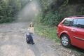
Ready to head to the hash
Elisa was eager to take pictures
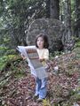
Elisa holding the map
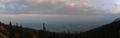
Panorama before the last few hundred meters to the hash
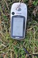
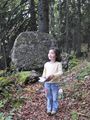
Coordinates reached
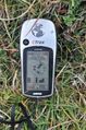
Coordinates reached
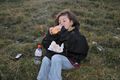
Elisa eating at the hash
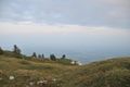
View down from the hash


Tracklog: [1]