Difference between revisions of "2009-10-02 50 6"
imported>Teutschini (→Expedition) |
|||
| (9 intermediate revisions by 3 users not shown) | |||
| Line 41: | Line 41: | ||
Image:2009-##-## ## ## Beta.jpg | Witty Comment | Image:2009-##-## ## ## Beta.jpg | Witty Comment | ||
--> | --> | ||
| − | <gallery perrow=" | + | <gallery perrow="6"> |
| − | + | Image:2009-10-02_50_6 01.JPG | Let's start geohashing | |
| + | Image:2009-10-02_50_6 02.JPG | The only lifeforms I encountered on my expedition before I saw the bull | ||
| + | Image:2009-10-02_50_6 03.JPG | My first hash point marker | ||
| + | Image:2009-10-02_50_6 04.JPG | Marker flag in perfect focus | ||
| + | Image:2009-10-02_50_6 05.JPG | The high stand and the marker | ||
| + | Image:2009-10-02_50_6 06.JPG | 2ms to take a photo of me and the marker (sic!) | ||
</gallery> | </gallery> | ||
| − | |||
| − | |||
| − | |||
| − | |||
| − | |||
| − | |||
[[Category:Expeditions]] | [[Category:Expeditions]] | ||
| − | |||
[[Category:Expeditions with photos]] | [[Category:Expeditions with photos]] | ||
| − | |||
| − | |||
| − | |||
| − | |||
| − | |||
[[Category:Coordinates reached]] | [[Category:Coordinates reached]] | ||
| − | + | {{location|DE|RP|AW}} | |
| − | |||
| − | |||
| − | |||
| − | |||
| − | |||
| − | |||
| − | |||
| − | |||
| − | |||
Latest revision as of 17:55, 19 April 2021
| Fri 2 Oct 2009 in 50,6: 50.5598731, 6.9992145 geohashing.info google osm bing/os kml crox |
Location
Near the Swistbach-Spring north of Altenahr. A glade in the 'Altendorfer Wald' used as a pasture just south of the border between Nordrhein-Westfalen and Rheinland-Pfalz. The hash point is at the western edge beside the Swistbach and a hunting high stand.
Participants
Plans
Teutschini is planning to reach that hash between 5 and 6 pm. No GPS, just paper maps.
Expedition
I thought this was an easy one to start with being not far away from the Autobahn and a 20 minute drive from the place I work. I'm still waiting for my GPS device to arrive. But as I'm a cartographer I've got the most detailed maps possible, using the TK25 (Scale 1:25000) to find my way to the glade and the DGK5 (Scale 1:5000) to find the exact spot.
I parked my car beside the 'Gasthaus Schönberg' at highway B257 and had an easy 30 minute walk to the glade, which was fenced with barbed wire. When I made my first photo of the hunting high stand at 10 to 5pm I realized I'd made the most rookie-ish mistake possible. Loss of camera power! Nevertheless I crossed the fence and erected my first ever hash point marker at the spot I'd identified on the map about 3m south of the high stand and 5m east of the creek. Guess I got it quite right but, well, no proof possible ;-)
Then I made a last attempt at documenting my conquest, warming up the batteries in my hands for a few minutes. I got enough power for 4 quick photos in 20 seconds, so no high quality there.
I spent another 15 minutes on the glade eating a sandwich and enjoying my achievement then made my way back, taking a way along the eastern edge of the glade to have a look at the marker from a different point of view. Well, there I had a view of the complete glade just to see that the barbed wire was there for a reason: Bull on the field!
Glad he didn't like my sandwich ...
Tracklog
Photos
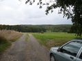
Let's start geohashing
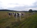
The only lifeforms I encountered on my expedition before I saw the bull
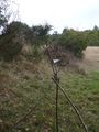
My first hash point marker
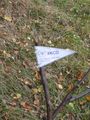
Marker flag in perfect focus
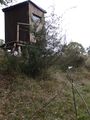
The high stand and the marker
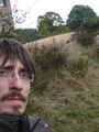
2ms to take a photo of me and the marker (sic!)


