Difference between revisions of "2009-11-06 37 -94"
imported>New User (writeup. It's been a while since I've done this so I hope I'm not forgetting anything!) |
imported>FippeBot m (Location) |
||
| Line 23: | Line 23: | ||
[[Category:Expeditions with photos]] | [[Category:Expeditions with photos]] | ||
[[Category:Coordinates reached]] | [[Category:Coordinates reached]] | ||
| + | {{location|US|MO|JS}} | ||
Latest revision as of 02:52, 6 August 2019
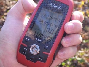
| Fri 6 Nov 2009 in Joplin, MO: 37.1107714, -94.4648176 geohashing.info google osm bing/os kml crox |
About
The hashpoint was behind some houses in a neighborhood in northern Joplin.
New User's expedition
I was visiting a friend in the area and as usual I check the geohashing web page to see if there are any easily accessible, non-private property hashpoints near my location. This time it was just a short distance from the shopping mall, and my friend needed to go there anyway to return some purchases. Since we both enjoy a good adventure, I took the opportunity to quickly try to explain the concept of geohashing to her. I don't think she quite understood, but since we were going to be near the point anyway and she's always up for something new we went to check it out.
The internet map showed the point to be in some trees, near private property. When we got there, we just parked our vehicle on the road near a cul-de-sac and got out and walked down a dry creek bed between two homes. I was pretty nervous to be walking practically in someone's backyard, but the hashpoint was so near the road that it was a very short walk until we were there. We snapped a quick photo and left, since there really wasn't anything interesting to see and we had other things planned for the afternoon.
It ended up being not much of an adventure, but at least this quickie got the drag-along achievement for me.
