Difference between revisions of "2009-11-11"
From Geohashing
imported>AperfectBot m (Ook.) |
imported>ReletBot m (moving from Template:auto gallery to Template:auto gallery2) |
||
| Line 1: | Line 1: | ||
<noinclude>{{date navigation}}</noinclude> | <noinclude>{{date navigation}}</noinclude> | ||
{{auto coordinates|2009-11-11}} | {{auto coordinates|2009-11-11}} | ||
| − | {{auto | + | {{auto gallery2|2009-11-11}} |
<noinclude>{{expedition summaries|2009-11-11}}</noinclude> | <noinclude>{{expedition summaries|2009-11-11}}</noinclude> | ||
Latest revision as of 22:35, 23 August 2010
Expedition Archives from November 2009
Tuesday 10 November 2009 | Wednesday 11 November 2009 | Thursday 12 November 2009
See also: Category:Meetup on 2009-11-11
Coordinates
West of -30°: .4330253, .0536451
East of -30°: .0989522, .2010321
Globalhash:
-72.188603496885,-107.628453476120
Photo Gallery
Expeditions and Plans
| 2009-11-11 | ||
|---|---|---|
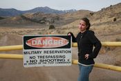
| Tooele, Utah | Geohashgirl | According to Google maps, there was supposed to be a military base nearby, ... |
| Boston, Massachusetts | Phyzome | Close to orange line! |
| McMinnville, Oregon | Jim | Forest Grove, Oregon. In woods on private land. |
