Difference between revisions of "2009-11-15 52 7"
From Geohashing
imported>Mihai |
imported>FippeBot m (Location) |
||
| Line 27: | Line 27: | ||
[[Category:Expeditions with photos]] | [[Category:Expeditions with photos]] | ||
[[Category:Coordinates reached]] | [[Category:Coordinates reached]] | ||
| + | {{location|DE|NI|EL}} | ||
Latest revision as of 06:50, 8 August 2019
| Sun 15 Nov 2009 in Rheine: 52.7217732, 7.4373941 geohashing.info google osm bing/os kml crox |
Participants
- User:Mihai
- Mihai's wife Izabella
Expedition
Another driving session for my wife, and thus: another expedition in the Rheine graticule. The ~25 km from Lingen to a small forest in Loherfeld was uneventful. Parking near a farmhouse at the forest, we walked the remaining 150m through the trees. It was a rainy day, but the ground was covered by fir needles, so it was quite comfortable. We didn't stay for long, just made a few photos and left a note on a tree. While eating something back in the car, a guy walked from the farmhouse and checked the whole street - he probably got suspicious, but didn't dare to just ask us. Well, maybe he'll find the note and figure it out. Hi there, if you read this!
Photos
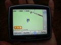
coordinates reached
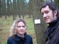
Izabella is freezing
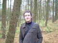
bye bye


