Difference between revisions of "2009-11-23 35 -106"
imported>Redaragorn (New page: {{meetup graticule | map=<map lat="35" lon="-106" date="2009-11-19" /> | lat=35 | lon=-106 | date=2009-11-19 }} == Location == A storm water catch basin not far off Juan Tabo Blvd about ...) |
imported>FippeBot m (Location) |
||
| (2 intermediate revisions by one other user not shown) | |||
| Line 1: | Line 1: | ||
{{meetup graticule | {{meetup graticule | ||
| − | | map=<map lat="35" lon="-106" date="2009-11- | + | | map=<map lat="35" lon="-106" date="2009-11-23" /> |
| lat=35 | | lat=35 | ||
| lon=-106 | | lon=-106 | ||
| − | | date=2009-11- | + | | date=2009-11-23 |
}} | }} | ||
== Location == | == Location == | ||
| − | + | In the parking lot of D&B Glass off Coors north of I-40 on the west side of Albuquerque. | |
== Participants == | == Participants == | ||
| Line 16: | Line 16: | ||
== Plans == | == Plans == | ||
| − | + | I saw that the hash was pretty close again today, so I figured I'd see how the time went after work and maybe make it down there. Since it was right off of Coors and in a parking lot, I knew access wasn't going to be any issue at all. | |
== Expedition == | == Expedition == | ||
| − | + | Another after work hash--headed home to collect the family and we made the short trip down to Coors above I-40. We found the parking lot no problem, but the boys were getting pretty tired. The three year old was out in the parking lot with me, looking for the red dot again on his own GPS. I took longer to wander around to the right spot than I really should have considering I knew exactly where it was from the aerial photos. I got to the spot, got my photos, and we headed for home. It didn't look like I was going to be joined by any fellow hashers anytime soon. | |
== Track == | == Track == | ||
| Line 30: | Line 30: | ||
<gallery> | <gallery> | ||
| − | Image:2009-11-23 35 -106 - GPS. | + | Image:2009-11-23 35 -106 - GPS.JPG|The coordinates to prove I was there. |
| − | Image:2009-11-23 35 -106 - grin. | + | Image:2009-11-23 35 -106 - grin.JPG|Goofy grin and such. |
</gallery> | </gallery> | ||
| Line 38: | Line 38: | ||
[[category:Expeditions]] [[category:Coordinates reached]] | [[category:Expeditions]] [[category:Coordinates reached]] | ||
| + | {{location|US|NM|BE}} | ||
Latest revision as of 06:54, 8 August 2019
| Mon 23 Nov 2009 in 35,-106: 35.1172381, -106.7000875 geohashing.info google osm bing/os kml crox |
Location
In the parking lot of D&B Glass off Coors north of I-40 on the west side of Albuquerque.
Participants
- Redaragorn and family
Plans
I saw that the hash was pretty close again today, so I figured I'd see how the time went after work and maybe make it down there. Since it was right off of Coors and in a parking lot, I knew access wasn't going to be any issue at all.
Expedition
Another after work hash--headed home to collect the family and we made the short trip down to Coors above I-40. We found the parking lot no problem, but the boys were getting pretty tired. The three year old was out in the parking lot with me, looking for the red dot again on his own GPS. I took longer to wander around to the right spot than I really should have considering I knew exactly where it was from the aerial photos. I got to the spot, got my photos, and we headed for home. It didn't look like I was going to be joined by any fellow hashers anytime soon.
Track
none
Pictures
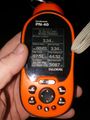
The coordinates to prove I was there.

Goofy grin and such.

