Difference between revisions of "2009-12-27 42 -124"
imported>Michael5000 (→Plans) |
m (per Renaming Proposal) |
||
| (6 intermediate revisions by 2 users not shown) | |||
| Line 1: | Line 1: | ||
| − | |||
<!-- If you did not specify these parameters in the template, please substitute appropriate things for IMAGE, LAT, LON, and DATE (YYYY-MM-DD format) --> | <!-- If you did not specify these parameters in the template, please substitute appropriate things for IMAGE, LAT, LON, and DATE (YYYY-MM-DD format) --> | ||
<!-- | <!-- | ||
| Line 27: | Line 26: | ||
== Expedition == | == Expedition == | ||
| + | We set out south from the 5000 family home in Bandon, and made it to Humbug Mountain in 45 minutes or so. Mrs.5000 had a better idea of what the site would look like, so was able to get michael5000 back to it after he overshot. We pulled off onto a large pad where road debris from landslides gets dumped. To get to the hashpoint itself, we had to go a little ways down a little-used track towards to beach, then bushwhack down into the draw of a small creek, and then slog back uphill a few dozen meters to the hashpoint. We brushed some mud off a log, took some pictures, and then noted the occasion in permanent marker on a little rock. | ||
| − | + | On the way back up, we gathered treasures! There was a lovely green-glass bottle that looked exotic and mysterious until I noticed it was marked "Gallo," and Mrs.5000 pulled a trunkload of rusty rebar out of the road debris for yard-sculpture purposes. On the way back, we stopped at a car wash to wash off the muck of the last two expeditions. | |
| + | {{Graticule unlocked | ||
| + | | latitude = 42 | ||
| + | | longitude = -124 | ||
| + | | date = 2009-12-27 | ||
| + | | name = Michael5000 and Mrs.5000 | ||
| + | |||
| + | }} | ||
== Photos == | == Photos == | ||
| − | |||
<gallery perrow="4"> | <gallery perrow="4"> | ||
| − | Image: | + | Image:20019-12-27 42 -124 01.jpg | View to the South |
| − | Image: | + | Image:20019-12-27 42 -124 02.jpg | Getting our bearings... |
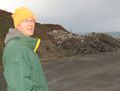
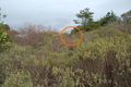
| + | Image:20019-12-27 42 -124 03.jpg | View to the North, toward Humbug Mountain. The hashpoint is in the draw ~50 meters away. | ||
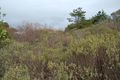
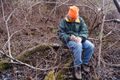
| + | Image:20019-12-27 42 -124 04.jpg | Looking more intrepid than usual. | ||
| + | Image:20019-12-27 42 -124 05.jpg | Mrs.5000 ready to roll | ||
| + | Image:20019-12-27 42 -124 06.jpg | The hash point is over there... | ||
| + | Image:20019-12-27 42 -124 07.jpg | ...by the tree. | ||
| + | Image:20019-12-27 42 -124 08.jpg | It requires a little bushwhacking | ||
| + | Image:20019-12-27 42 -124 09.jpg | At the hash, preparing a monument. | ||
| + | Image:20019-12-27 42 -124 10.jpg | Cinnamon Bear installs the monument | ||
| + | Image:20019-12-27 42 -124 11.jpg | Expedition Success! | ||
| + | Image:20019-12-27 42 -124 12.jpg | Spring comes early in Oregon... | ||
| + | Image:20019-12-27 42 -124 13.jpg | Mrs.5000 on the way out... | ||
| + | Image:20019-12-27 42 -124 14.jpg | The sun-bleached bones of geohashers who failed | ||
| + | Image:20019-12-27 42 -124 15.jpg | Mrs.5000 discovers a field of concrete rubble and rebar... | ||
| + | Image:20019-12-27 42 -124 16.jpg | ...and helps herself to some rebar | ||
</gallery> | </gallery> | ||
| − | |||
| − | |||
| − | |||
| − | |||
| − | |||
| − | |||
| − | |||
| − | + | ||
[[Category:Expeditions]] | [[Category:Expeditions]] | ||
| − | |||
[[Category:Expeditions with photos]] | [[Category:Expeditions with photos]] | ||
| − | |||
[[Category:Expedition without GPS]] | [[Category:Expedition without GPS]] | ||
| − | + | ||
| − | |||
| − | |||
[[Category:Coordinates reached]] | [[Category:Coordinates reached]] | ||
| − | + | {{location|US|OR|CU}} | |
| − | |||
| − | |||
| − | |||
| − | |||
| − | |||
| − | |||
| − | |||
| − | |||
| − | |||
Latest revision as of 06:19, 20 March 2024
| Sun 27 Dec 2009 in 42,-124: 42.6419810, -124.4083750 geohashing.info google osm bing/os kml crox |
Location
South of Humbug Mountain, just off Highway 101
Participants
Plans
With the Christmas holiday on Friday, we were able to plan for this expedition from Thursday morning. We spent some time with the aerial photo, satisfying ourselves that the slope at the hashpoint would be gradual, and wouldn't involve any cliffs.
Expedition
We set out south from the 5000 family home in Bandon, and made it to Humbug Mountain in 45 minutes or so. Mrs.5000 had a better idea of what the site would look like, so was able to get michael5000 back to it after he overshot. We pulled off onto a large pad where road debris from landslides gets dumped. To get to the hashpoint itself, we had to go a little ways down a little-used track towards to beach, then bushwhack down into the draw of a small creek, and then slog back uphill a few dozen meters to the hashpoint. We brushed some mud off a log, took some pictures, and then noted the occasion in permanent marker on a little rock.
On the way back up, we gathered treasures! There was a lovely green-glass bottle that looked exotic and mysterious until I noticed it was marked "Gallo," and Mrs.5000 pulled a trunkload of rusty rebar out of the road debris for yard-sculpture purposes. On the way back, we stopped at a car wash to wash off the muck of the last two expeditions.
Michael5000 and Mrs.5000 earned the Graticule Unlocked Achievement
|
Photos
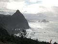
View to the South
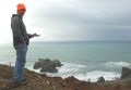
Getting our bearings...
- Error creating thumbnail: Unable to save thumbnail to destination
View to the North, toward Humbug Mountain. The hashpoint is in the draw ~50 meters away.
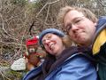
Looking more intrepid than usual.

Mrs.5000 ready to roll
The hash point is over there...
...by the tree.
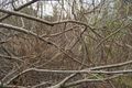
It requires a little bushwhacking
At the hash, preparing a monument.
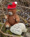
Cinnamon Bear installs the monument
Expedition Success!
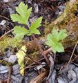
Spring comes early in Oregon...

Mrs.5000 on the way out...
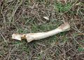
The sun-bleached bones of geohashers who failed
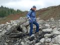
Mrs.5000 discovers a field of concrete rubble and rebar...
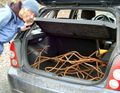
...and helps herself to some rebar


