Difference between revisions of "2009-12-16 50 0"
imported>Davidc |
m (per Renaming Proposal) |
||
| (4 intermediate revisions by 3 users not shown) | |||
| Line 3: | Line 3: | ||
| lon=0 | | lon=0 | ||
| date=2009-12-16 | | date=2009-12-16 | ||
| + | | graticule_name=Eastbourne, UK | ||
| + | | graticule_link=Eastbourne, United Kingdom | ||
}} | }} | ||
| − | |||
__NOTOC__ | __NOTOC__ | ||
== Location == | == Location == | ||
| Line 20: | Line 21: | ||
== Expedition == | == Expedition == | ||
| + | The hashpoint was in a field behind Place Farm in Chiddingly. I tried to reach it through the farm buildings but there was no public access; fortunately a lady told me that there was a public footpath at the rear. | ||
| − | + | In fact, given the recent weather, the footpaths were virtual swamps and nigh-on untraversable. I'd also forgotten my wellies, and nearly destroyed a lovely pair of shoes in my determination. | |
| + | The hashpoint was at the edge of a partly frosted field, marked by the carcass of some animal or another. Grins snapped, I returned home from the double-hash across the Prime Meridian. | ||
== Photos == | == Photos == | ||
| − | |||
<gallery perrow="4"> | <gallery perrow="4"> | ||
| − | + | File:2009-12-16_50_0_IMG_2013.JPG|Farm sign | |
| − | + | File:2009-12-16_50_0_IMG_2011.JPG|Farmhouse | |
| + | File:2009-12-16_50_0_IMG_2010.JPG|Farm buildings | ||
| + | File:2009-12-16_50_0_IMG_1994.JPG|Stile | ||
| + | File:2009-12-16_50_0_IMG_1995.JPG|Dungfire | ||
| + | File:2009-12-16_50_0_IMG_1996.JPG|Sodden footpath | ||
| + | File:2009-12-16_50_0_IMG_1997.JPG|A choice of four public swamp-paths | ||
| + | File:2009-12-16_50_0_IMG_2008.JPG|Frozen hash-field | ||
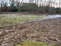
| + | File:2009-12-16_50_0_IMG_2009.JPG|Unfrozen hash-field | ||
| + | File:2009-12-16_50_0_IMG_0068.PNG|GPS screenshot | ||
| + | File:2009-12-16_50_0_IMG_1998.JPG|Hash-carcass | ||
| + | File:2009-12-16_50_0_IMG_2000.JPG|Silly grin! | ||
</gallery> | </gallery> | ||
| − | |||
| + | == Ribbons == | ||
| + | |||
| + | {{Multihash|latitude1=50|longitude1=-0|latitude2=50|longitude2=0|date=2009-12-16|name=[[User:Davidc|davidc]]}} | ||
| + | |||
| + | {{Graticule unlocked | ||
| + | | latitude = 50 | ||
| + | | longitude = 0 | ||
| + | | date = 2009-12-16 | ||
| + | | name = [[User:davidc|davidc]] | ||
| + | }} | ||
[[Category:Expeditions]] | [[Category:Expeditions]] | ||
[[Category:Expeditions with photos]] | [[Category:Expeditions with photos]] | ||
[[Category:Coordinates reached]] | [[Category:Coordinates reached]] | ||
| + | {{location|GB|ENG|ESX}} | ||
Latest revision as of 06:19, 20 March 2024
| Wed 16 Dec 2009 in Eastbourne, UK: 50.9047030, 0.1838178 geohashing.info google osm bing/os kml crox |
Location
Edge of a field in Chiddingly, Sussex.
Participants
Plans
None
Expedition
The hashpoint was in a field behind Place Farm in Chiddingly. I tried to reach it through the farm buildings but there was no public access; fortunately a lady told me that there was a public footpath at the rear.
In fact, given the recent weather, the footpaths were virtual swamps and nigh-on untraversable. I'd also forgotten my wellies, and nearly destroyed a lovely pair of shoes in my determination.
The hashpoint was at the edge of a partly frosted field, marked by the carcass of some animal or another. Grins snapped, I returned home from the double-hash across the Prime Meridian.
Photos
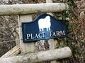
Farm sign
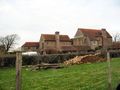
Farmhouse
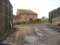
Farm buildings
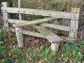
Stile
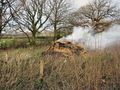
Dungfire
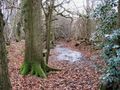
Sodden footpath
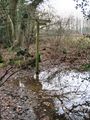
A choice of four public swamp-paths
Frozen hash-field
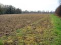
Unfrozen hash-field
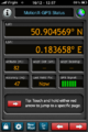
GPS screenshot
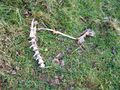
Hash-carcass

Silly grin!


Ribbons
davidc earned the Multihash Achievement
|
davidc earned the Graticule Unlocked Achievement
|