Difference between revisions of "2010-01-31 -35 144"
imported>Kozz (→Plans) |
m (per Renaming Proposal) |
||
| (10 intermediate revisions by 3 users not shown) | |||
| Line 1: | Line 1: | ||
| − | |||
| − | |||
| − | |||
| − | |||
| − | |||
| − | |||
| − | |||
{{meetup graticule | {{meetup graticule | ||
| lat=-35 | | lat=-35 | ||
| Line 11: | Line 4: | ||
| date=2010-01-31 | | date=2010-01-31 | ||
}} | }} | ||
| − | |||
| − | |||
| − | |||
== Location == | == Location == | ||
| − | + | 200m from the side of the Cobb Highway on the Long Paddock | |
== Participants == | == Participants == | ||
| − | + | [[user:Kozz | Kozz]] <br/> | |
| + | 2 x intrigued New South Welshmen <br/> | ||
| + | 1 x 10-month-old baby <br/> | ||
== Plans == | == Plans == | ||
| − | + | Snap decision - 20km north of Deniliquin - let's roll. Day two of a [[2010-01-30 -37 144|two-day road trip]]. | |
== Expedition == | == Expedition == | ||
| + | Second part of the road trip up to New South Wales, and we're in the Deniliquin graticule. I woke up in the morning, switched on the netbook and discovered a nearby unsecured wireless point - jackpot! Just enough time to login, check out the local graticule and do a bit of planning. | ||
| + | |||
| + | We breakfasted in Deniliquin which is right on the Cobb Highway, where the hashpoint appeared to be. I checked it out on Google Maps and Street View, and it looked like public access for quite a ways beyond the edge of the road. I worried initially about it being unmarked private property, but when I asked one of the friends we'd stayed with overnight he assured me that this particular road has hundreds of metres of publicly accessible space either side of the road for drovers to drove cattle through. | ||
| + | I was intrigued; the image of a geohash interrupted by several hundred head of angry Australian cattle stampeding along a highway. Further discussion revealed that this particular road was [http://en.wikipedia.org/wiki/Long_Paddock once a route for farmers] to herd their cattle from one place to another without dropping onto other people's properties. The practice has died out totally since the advent of cattle transport trucks, but the historical reserve remains, and until relatively recently was put to use as a form of additional feed for drought-stricken cattle. The idea being that farmers could apply for permit to walk their cattle through this area, allowing them to graze along the way. However, the drought has put paid to even this practice as the various environmental agencies attempt to allow the native grasses to regenerate. | ||
| − | + | He asked why I was enquiring as to this particular spot on the Hay Plains (that's what they're called - there's a place called 'Hay' about 100km from the hashpoint), then, intrigued by the concept of Geohashing he was easily convinced to come along for the ride. Then he decided to bring along his ten-month-old son. And his wife also decided to come along for the ride too... | |
| + | We drove from Deniliquin up along the highway and got within a couple of hundred metres of the hashpoint without any major difficulties, but my handheld GPS had a heap of trouble picking up its location so I had to use the satnav to direct the car along access roads cut into the scrub. We drove for quite a way - several hundred metres - and ended up within 30m or so of the hashpoint. I'd hoped to be able to get a photo of the 10-month-old on the hashpoint properly, but he'd just dropped off to sleep. Mum and Dad elected to stay in the air-conditioned car whilst I braved the 37 degree celcius heat and wandered round in circles trying to get as close as possible to the hashpoint. I snapped the obligatory photos, including a panorama of the plains [{{filepath:2010-01-31_-35_144_The_hashpoint_magic_thorn_bush_(Medium).JPG}} AND a bonus out-of-focus fly] and we departed. | ||
| + | |||
| + | I don't have date evidence aside from the exif data on the camera, the coords and a solemn promise. No geotrash this time, either - there was nothing at the hashpoint that far from the highway. | ||
| + | |||
| + | :Edit - I found out what's wrong with the handheld GPS. Apparently spending under $50 on a unit off ebay isn't going to secure you the best up-to-date equipment in the world - there's a firmware issue with this horrible little piece of technology that can only be fixed by reflashing the memory, which requires the purchase of a $25 cable. Otherwise it will continue to take 45 minutes to pick up satellites. Joy... | ||
== Photos == | == Photos == | ||
| − | |||
<gallery perrow="4"> | <gallery perrow="4"> | ||
| − | Image: | + | Image:2010-01-31 -35 144 Entry Road.jpg | The entry point to the scrubland |
| − | Image: | + | Image:2010-01-31 -35 144 Driving In (Medium).JPG | The access road on the way in |
| + | Image:2010-01-31 -35 144 Car Pano.jpg | Exiting the car near the hashpoint | ||
| + | Image:2010-01-31 -35 144 Drag alongs staying in thhe car (Medium).JPG | It's cooler in the car | ||
| + | Image:2010-01-31 -35 144 Hashpoint towards car (Medium).JPG | Looking east | ||
| + | Image:2010-01-31 -35 144 Somewhat dry (Medium).JPG | A decade o' drought will do this to a place | ||
| + | Image:2010-01-31 -35 144 The hashpoint magic thorn bush (Medium).JPG | This little bush happily took some of my skin as a souvenir | ||
| + | Image:2010-01-31 -35 144 Under a deep blue sky (Medium).JPG | The nearest habitation - a barn | ||
| + | Image:2010-01-31 -35 144 Within a metre (Medium).JPG | Within a metre or so | ||
| + | Image:2010-01-31 -35 144 Hashpoint Panorama.jpg | The vista at the hashpoint | ||
| + | Image:2010-01-31 -35 144 Nearby Pretty Pine (Medium).JPG | Pretty Pine? Really? | ||
</gallery> | </gallery> | ||
| − | |||
| + | {{consecutive geohash | ||
| + | | count = 2 | ||
| + | | latitude = -37 | ||
| + | | longitude = 144 | ||
| + | | date = 2010-01-30 | ||
| + | | name = Kozz | ||
| + | }} | ||
| + | {{Graticule unlocked | ||
| + | | latitude = -35 | ||
| + | | longitude = 144 | ||
| + | | date = 2010-01-31 | ||
| + | | name = Kozz | ||
| + | }} | ||
| + | {{drag-along | ||
| + | | latitude = -35 | ||
| + | | longitude = 144 | ||
| + | | date = 2010-01-31 | ||
| + | | partner = two intrigued New South Welshmen | ||
| + | | name = Kozz | ||
| + | }} | ||
| − | |||
| − | |||
| − | |||
| − | |||
| − | |||
| − | |||
| − | |||
| − | |||
| − | |||
[[Category:Expeditions]] | [[Category:Expeditions]] | ||
| − | |||
[[Category:Expeditions with photos]] | [[Category:Expeditions with photos]] | ||
| − | |||
| − | |||
| − | |||
| − | |||
| − | |||
[[Category:Coordinates reached]] | [[Category:Coordinates reached]] | ||
| − | + | {{location|AU|NSW|ER}} | |
| − | |||
| − | |||
| − | |||
| − | |||
| − | |||
| − | |||
| − | |||
| − | |||
| − | |||
Latest revision as of 06:17, 20 March 2024
| Sun 31 Jan 2010 in -35,144: -35.3697908, 144.8551778 geohashing.info google osm bing/os kml crox |
Contents
Location
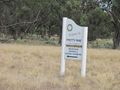
200m from the side of the Cobb Highway on the Long Paddock
Participants
Kozz
2 x intrigued New South Welshmen
1 x 10-month-old baby
Plans
Snap decision - 20km north of Deniliquin - let's roll. Day two of a two-day road trip.
Expedition
Second part of the road trip up to New South Wales, and we're in the Deniliquin graticule. I woke up in the morning, switched on the netbook and discovered a nearby unsecured wireless point - jackpot! Just enough time to login, check out the local graticule and do a bit of planning.
We breakfasted in Deniliquin which is right on the Cobb Highway, where the hashpoint appeared to be. I checked it out on Google Maps and Street View, and it looked like public access for quite a ways beyond the edge of the road. I worried initially about it being unmarked private property, but when I asked one of the friends we'd stayed with overnight he assured me that this particular road has hundreds of metres of publicly accessible space either side of the road for drovers to drove cattle through.
I was intrigued; the image of a geohash interrupted by several hundred head of angry Australian cattle stampeding along a highway. Further discussion revealed that this particular road was once a route for farmers to herd their cattle from one place to another without dropping onto other people's properties. The practice has died out totally since the advent of cattle transport trucks, but the historical reserve remains, and until relatively recently was put to use as a form of additional feed for drought-stricken cattle. The idea being that farmers could apply for permit to walk their cattle through this area, allowing them to graze along the way. However, the drought has put paid to even this practice as the various environmental agencies attempt to allow the native grasses to regenerate.
He asked why I was enquiring as to this particular spot on the Hay Plains (that's what they're called - there's a place called 'Hay' about 100km from the hashpoint), then, intrigued by the concept of Geohashing he was easily convinced to come along for the ride. Then he decided to bring along his ten-month-old son. And his wife also decided to come along for the ride too...
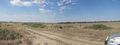
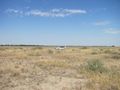
We drove from Deniliquin up along the highway and got within a couple of hundred metres of the hashpoint without any major difficulties, but my handheld GPS had a heap of trouble picking up its location so I had to use the satnav to direct the car along access roads cut into the scrub. We drove for quite a way - several hundred metres - and ended up within 30m or so of the hashpoint. I'd hoped to be able to get a photo of the 10-month-old on the hashpoint properly, but he'd just dropped off to sleep. Mum and Dad elected to stay in the air-conditioned car whilst I braved the 37 degree celcius heat and wandered round in circles trying to get as close as possible to the hashpoint. I snapped the obligatory photos, including a panorama of the plains AND a bonus out-of-focus fly and we departed.
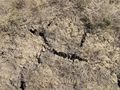
I don't have date evidence aside from the exif data on the camera, the coords and a solemn promise. No geotrash this time, either - there was nothing at the hashpoint that far from the highway.
- Edit - I found out what's wrong with the handheld GPS. Apparently spending under $50 on a unit off ebay isn't going to secure you the best up-to-date equipment in the world - there's a firmware issue with this horrible little piece of technology that can only be fixed by reflashing the memory, which requires the purchase of a $25 cable. Otherwise it will continue to take 45 minutes to pick up satellites. Joy...
Photos
The entry point to the scrubland
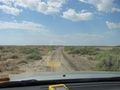
The access road on the way in
Exiting the car near the hashpoint
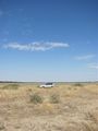
It's cooler in the car
Looking east
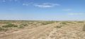
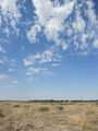
A decade o' drought will do this to a place
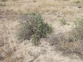
This little bush happily took some of my skin as a souvenir
The nearest habitation - a barn
Within a metre or so

The vista at the hashpoint
Pretty Pine? Really?

.JPG)
.JPG)
.JPG)
.JPG)
.JPG)
.JPG)
.JPG)
.JPG)
Kozz earned the Consecutive geohash achievement
|
Kozz earned the Graticule Unlocked Achievement
|
Kozz earned the Drag-along achievement
|