Difference between revisions of "2010-02-01 48 8"
imported>Ekorren m (template only yet, report follows) |
imported>FippeBot m (Location) |
||
| (3 intermediate revisions by one other user not shown) | |||
| Line 1: | Line 1: | ||
| − | |||
| − | |||
| − | |||
| − | |||
| − | |||
| − | |||
| − | |||
{{meetup graticule | {{meetup graticule | ||
| lat=48 | | lat=48 | ||
| Line 12: | Line 5: | ||
}} | }} | ||
| − | |||
| − | |||
== Location == | == Location == | ||
| + | A white spot on a white field in a white world. Not far from Neustetten-Wolfenhausen. | ||
| + | |||
| + | On the map, that area is called ''Kuh'' - cow. However, there were no such creatures in sight. | ||
== Participants == | == Participants == | ||
| + | [[User:Ekorren|Ekorren]] | ||
| + | |||
| + | == Expedition == | ||
| + | |||
| + | It was cold, there was snow, but after months of only far coordinates, I was quite eager to go geohashing again. Also, I "had to" falsify the statement of someone else that with the current weather, noone will go anywhere by bike ;-) | ||
| − | + | I expected that on field and forest tracks, and that also means on many of the good bike trails, snow and ice would quite spoil the ride, and potentially make it dangerous. So I chose a route which would certainly count as the beaten path: Along a well-used bike trail to Wurmlingen, and from there on minor country roads. It was a good choice, since there was only a very thin layer of snow, and no ice, on the trail; while the roads were all clear. | |
| + | About one kilometre from the hash, there was a geocache I had not found several times before - as I know now, it was because the coordinates had changed and I had been searching at the old location. This time I was successful. But this time I had the correct coordinates with me, so it wasn't so much of a surprise. | ||
| − | + | Then weather suddenly changed: Temperature dropped, wind changed from light to strong, fresh snow started to fall. I don't think that qualifies for a snowstorm, but it was ''not'' comfortable, especially as it was straight headwind. However, that would mean that on the way back it's backwind, and with that no serious problem. And you simply don't give up one kilometre before the hash, do you? | |
| + | |||
| + | So I went on, against a freezing wind, snow hitting my face at ridiculous speed, and reached the place where I had to turn away from the road. 370 m to go, as the bird flies. 370 m through a white hell of snow on frozen fields, where you never know whether you just step on a rock or into a ravine. But you simply don't give up 370 m before the hash, do you? | ||
| + | There should be some paved track. A close examination of the white surface showed some straight strip of flatness, which probably marked the track. It did. A few hundred metres later, I could turn on another track which had been used by tractors, so the snow was compressed and easier to ride on. That one lead me within of 100 m of the hash, where I parked the bike and walked into the frozen field. Since it was really frozen, and snow covered, I think that walking in there didn't hurt any plant. | ||
| − | + | Coordinates reached in the middle of a field, surrounded by a lot of white and little other colours. Nothing notable there, not much notable on the way back, which went on minor roads to Rottenburg and home from there on a well-travelled, well-maintained bike trail which was already part of many other hashing trips. | |
| + | Also, those winter landscapes are always beautiful. | ||
== Photos == | == Photos == | ||
| − | |||
<gallery perrow="4"> | <gallery perrow="4"> | ||
| − | + | File:2010-02-01_48_8_Ammertalbahn.jpg|Upper way for the lazy ones, lower one for the less lazy ones. | |
| − | + | File:2010-02-01_48_8_Radfahrer_frei.jpg|<i>Bicyclists allowed until Hirschau and Wurmlingen</i>. This actually is the standard way, and there was nothing like a closure somewhere... | |
| + | File:2010-02-01_48_8_Wurmlingen_1.jpg|Wurmlingen chapel | ||
| + | File:2010-02-01_48_8_Wurmlingen_2.jpg|Wurmlingen chapel again | ||
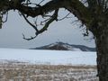
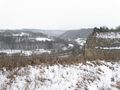
| + | File:2010-02-01_48_8_Heuberg.jpg|Random impressions | ||
| + | File:2010-02-01_48_8_Baeume.jpg | ||
| + | File:2010-02-01_48_8_Wald.jpg | ||
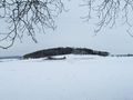
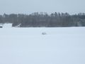
| + | File:2010-02-01_48_8_ViewOnHash.jpg|The hash is out there in the light gray | ||
| + | File:2010-02-01_48_8_Weg.jpg|Recommended bike trail | ||
| + | File:2010-02-01_48_8_GPS.jpg|Coordinates reached | ||
| + | File:2010-02-01_48_8_Marker.jpg|Kind of a marker | ||
| + | File:2010-02-01_48_8_View_from_hash_1.jpg|View from hash | ||
| + | File:2010-02-01_48_8_ViewFromHash_2.jpg|View from hash | ||
| + | File:2010-02-01_48_8_Bike.jpg|Bike waiting at the track | ||
| + | File:2010-02-01_48_8_Neckartal.jpg|View into the Neckar valley | ||
</gallery> | </gallery> | ||
| − | |||
| − | |||
| − | |||
| − | |||
| − | |||
| − | |||
| − | |||
| − | |||
| − | |||
| − | |||
[[Category:Expeditions]] | [[Category:Expeditions]] | ||
| − | |||
[[Category:Expeditions with photos]] | [[Category:Expeditions with photos]] | ||
| − | |||
| − | |||
| − | |||
| − | |||
| − | |||
[[Category:Coordinates reached]] | [[Category:Coordinates reached]] | ||
| − | + | {{location|DE|BW|TÜ}} | |
| − | |||
| − | |||
| − | |||
| − | |||
| − | |||
| − | |||
| − | |||
| − | |||
| − | |||
Latest revision as of 00:42, 9 August 2019
| Mon 1 Feb 2010 in 48,8: 48.4945115, 8.8367276 geohashing.info google osm bing/os kml crox |
Contents
[hide]Location
A white spot on a white field in a white world. Not far from Neustetten-Wolfenhausen.
On the map, that area is called Kuh - cow. However, there were no such creatures in sight.
Participants
Expedition
It was cold, there was snow, but after months of only far coordinates, I was quite eager to go geohashing again. Also, I "had to" falsify the statement of someone else that with the current weather, noone will go anywhere by bike ;-)
I expected that on field and forest tracks, and that also means on many of the good bike trails, snow and ice would quite spoil the ride, and potentially make it dangerous. So I chose a route which would certainly count as the beaten path: Along a well-used bike trail to Wurmlingen, and from there on minor country roads. It was a good choice, since there was only a very thin layer of snow, and no ice, on the trail; while the roads were all clear.
About one kilometre from the hash, there was a geocache I had not found several times before - as I know now, it was because the coordinates had changed and I had been searching at the old location. This time I was successful. But this time I had the correct coordinates with me, so it wasn't so much of a surprise.
Then weather suddenly changed: Temperature dropped, wind changed from light to strong, fresh snow started to fall. I don't think that qualifies for a snowstorm, but it was not comfortable, especially as it was straight headwind. However, that would mean that on the way back it's backwind, and with that no serious problem. And you simply don't give up one kilometre before the hash, do you?
So I went on, against a freezing wind, snow hitting my face at ridiculous speed, and reached the place where I had to turn away from the road. 370 m to go, as the bird flies. 370 m through a white hell of snow on frozen fields, where you never know whether you just step on a rock or into a ravine. But you simply don't give up 370 m before the hash, do you?
There should be some paved track. A close examination of the white surface showed some straight strip of flatness, which probably marked the track. It did. A few hundred metres later, I could turn on another track which had been used by tractors, so the snow was compressed and easier to ride on. That one lead me within of 100 m of the hash, where I parked the bike and walked into the frozen field. Since it was really frozen, and snow covered, I think that walking in there didn't hurt any plant.
Coordinates reached in the middle of a field, surrounded by a lot of white and little other colours. Nothing notable there, not much notable on the way back, which went on minor roads to Rottenburg and home from there on a well-travelled, well-maintained bike trail which was already part of many other hashing trips.
Also, those winter landscapes are always beautiful.
Photos
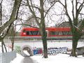
Upper way for the lazy ones, lower one for the less lazy ones.
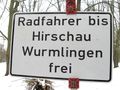
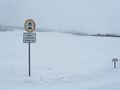
Bicyclists allowed until Hirschau and Wurmlingen. This actually is the standard way, and there was nothing like a closure somewhere...

Wurmlingen chapel
Wurmlingen chapel again
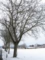
Random impressions
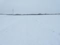
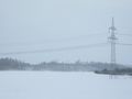
The hash is out there in the light gray
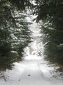
Recommended bike trail
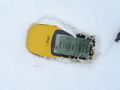
Coordinates reached
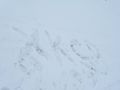
Kind of a marker
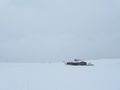
View from hash
View from hash
Bike waiting at the track
View into the Neckar valley


