Difference between revisions of "2010-01-28 52 5"
imported>Antior (Created page with '{{subst:Expedition |lat = 52 |lon = 5 |date = 2010-01-28 }}') |
imported>FippeBot m (Location) |
||
| (8 intermediate revisions by 2 users not shown) | |||
| Line 1: | Line 1: | ||
| + | [[Image:2010-01-28-52-5f.jpg|thumb|left]] | ||
| − | |||
| − | |||
| − | |||
| − | |||
| − | |||
| − | |||
{{meetup graticule | {{meetup graticule | ||
| lat=52 | | lat=52 | ||
| Line 12: | Line 7: | ||
}} | }} | ||
| − | |||
__NOTOC__ | __NOTOC__ | ||
== Location == | == Location == | ||
| − | + | Utrecht, Schepenbuurt | |
== Participants == | == Participants == | ||
| − | + | A friend of CO2. [[User:CO2|CO2]] himself wasn't here. | |
== Plans == | == Plans == | ||
| − | + | CO2 saw the Hashpoint was nearby but didn't have time to go there himself. Therefore, he asked a friend to go. | |
== Expedition == | == Expedition == | ||
| + | ''(This report was written by CO2's friend)'' | ||
| − | + | The Hashpoint was on the other side of town for me, so I went there by bike. In the beginning the sun was shining, but somewhere halfway it started to rain a little bit. After I arrived at the Schoenerstraat in the Schepenbuurt, the rain had stopped, so I could take some good pictures. I didn't have a GPS, so you have to believe I got there. The Schoenerstraat crossed the Tjalkstraat and there in an alleyway was the tree which was the Hashpoint. I left a note with the XKCD geohash picture and forgot to add the date, but still, it was enjoyable. I had some people staring at me like I was crazy because I was taking so much pictures of a perfectly ordinary tree in a backyard, but that was fun too. | |
| − | |||
== Photos == | == Photos == | ||
| − | |||
| − | |||
<gallery perrow="4"> | <gallery perrow="4"> | ||
| − | Image: | + | Image:2010-01-28-52-5a.jpg | On the way to the hashpoint... |
| − | Image: | + | Image:2010-01-28-52-5b.jpg | Looking for the correct tree... |
| + | Image:2010-01-28-52-5c.jpg | There is the right street! | ||
| + | Image:2010-01-28-52-5d.jpg | It should be near the intersection with this street. | ||
| + | Image:2010-01-28-52-5e.jpg | If Google Maps is correct, it should be at that tree. | ||
| + | Image:2010-01-28-52-5f.jpg | Ah, an alleyway right next to the tree. Convenient! | ||
| + | Image:2010-01-28-52-5g.jpg | Nice empty wall right at the hashpoint. | ||
| + | Image:2010-01-28-52-5h.jpg | Let's put the Geohashing comic up. :) | ||
</gallery> | </gallery> | ||
| − | |||
| − | |||
| − | |||
| − | |||
| − | + | Also there's a little youtube clip made around the hashpoint [http://www.youtube.com/watch?v=MDC7LzHqdWo here]. | |
| − | |||
| − | [ | ||
| − | |||
| − | |||
[[Category:Expeditions]] | [[Category:Expeditions]] | ||
| − | |||
[[Category:Expeditions with photos]] | [[Category:Expeditions with photos]] | ||
[[Category:Expeditions with videos]] | [[Category:Expeditions with videos]] | ||
[[Category:Expedition without GPS]] | [[Category:Expedition without GPS]] | ||
| − | |||
| − | |||
| − | |||
[[Category:Coordinates reached]] | [[Category:Coordinates reached]] | ||
| − | + | {{location|NL|UT}} | |
| − | |||
| − | |||
| − | |||
| − | |||
| − | |||
| − | |||
| − | |||
| − | |||
| − | |||
Latest revision as of 00:38, 9 August 2019

| Thu 28 Jan 2010 in 52,5: 52.0983223, 5.0846867 geohashing.info google osm bing/os kml crox |
Location
Utrecht, Schepenbuurt
Participants
A friend of CO2. CO2 himself wasn't here.
Plans
CO2 saw the Hashpoint was nearby but didn't have time to go there himself. Therefore, he asked a friend to go.
Expedition
(This report was written by CO2's friend)
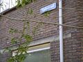
The Hashpoint was on the other side of town for me, so I went there by bike. In the beginning the sun was shining, but somewhere halfway it started to rain a little bit. After I arrived at the Schoenerstraat in the Schepenbuurt, the rain had stopped, so I could take some good pictures. I didn't have a GPS, so you have to believe I got there. The Schoenerstraat crossed the Tjalkstraat and there in an alleyway was the tree which was the Hashpoint. I left a note with the XKCD geohash picture and forgot to add the date, but still, it was enjoyable. I had some people staring at me like I was crazy because I was taking so much pictures of a perfectly ordinary tree in a backyard, but that was fun too.
Photos
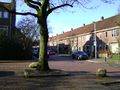
On the way to the hashpoint...
Looking for the correct tree...
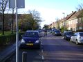
There is the right street!
It should be near the intersection with this street.
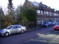
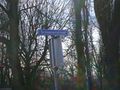
If Google Maps is correct, it should be at that tree.
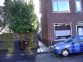
Ah, an alleyway right next to the tree. Convenient!
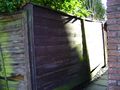
Nice empty wall right at the hashpoint.
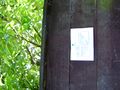
Let's put the Geohashing comic up. :)


Also there's a little youtube clip made around the hashpoint here.