Difference between revisions of "2010-01-28 52 5"
imported>Antior |
imported>FippeBot m (Location) |
||
| (6 intermediate revisions by 2 users not shown) | |||
| Line 1: | Line 1: | ||
| + | [[Image:2010-01-28-52-5f.jpg|thumb|left]] | ||
| + | |||
{{meetup graticule | {{meetup graticule | ||
| lat=52 | | lat=52 | ||
| Line 5: | Line 7: | ||
}} | }} | ||
| − | |||
__NOTOC__ | __NOTOC__ | ||
== Location == | == Location == | ||
| Line 11: | Line 12: | ||
== Participants == | == Participants == | ||
| − | A friend of | + | A friend of CO2. [[User:CO2|CO2]] himself wasn't here. |
== Plans == | == Plans == | ||
| − | + | CO2 saw the Hashpoint was nearby but didn't have time to go there himself. Therefore, he asked a friend to go. | |
== Expedition == | == Expedition == | ||
| − | ( | + | ''(This report was written by CO2's friend)'' |
| + | |||
| + | The Hashpoint was on the other side of town for me, so I went there by bike. In the beginning the sun was shining, but somewhere halfway it started to rain a little bit. After I arrived at the Schoenerstraat in the Schepenbuurt, the rain had stopped, so I could take some good pictures. I didn't have a GPS, so you have to believe I got there. The Schoenerstraat crossed the Tjalkstraat and there in an alleyway was the tree which was the Hashpoint. I left a note with the XKCD geohash picture and forgot to add the date, but still, it was enjoyable. I had some people staring at me like I was crazy because I was taking so much pictures of a perfectly ordinary tree in a backyard, but that was fun too. | ||
| Line 31: | Line 34: | ||
Image:2010-01-28-52-5h.jpg | Let's put the Geohashing comic up. :) | Image:2010-01-28-52-5h.jpg | Let's put the Geohashing comic up. :) | ||
</gallery> | </gallery> | ||
| − | + | ||
| + | |||
| + | Also there's a little youtube clip made around the hashpoint [http://www.youtube.com/watch?v=MDC7LzHqdWo here]. | ||
[[Category:Expeditions]] | [[Category:Expeditions]] | ||
| Line 38: | Line 43: | ||
[[Category:Expedition without GPS]] | [[Category:Expedition without GPS]] | ||
[[Category:Coordinates reached]] | [[Category:Coordinates reached]] | ||
| + | {{location|NL|UT}} | ||
Latest revision as of 00:38, 9 August 2019
| Thu 28 Jan 2010 in 52,5: 52.0983223, 5.0846867 geohashing.info google osm bing/os kml crox |
Location
Utrecht, Schepenbuurt
Participants
A friend of CO2. CO2 himself wasn't here.
Plans
CO2 saw the Hashpoint was nearby but didn't have time to go there himself. Therefore, he asked a friend to go.
Expedition
(This report was written by CO2's friend)
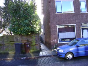
The Hashpoint was on the other side of town for me, so I went there by bike. In the beginning the sun was shining, but somewhere halfway it started to rain a little bit. After I arrived at the Schoenerstraat in the Schepenbuurt, the rain had stopped, so I could take some good pictures. I didn't have a GPS, so you have to believe I got there. The Schoenerstraat crossed the Tjalkstraat and there in an alleyway was the tree which was the Hashpoint. I left a note with the XKCD geohash picture and forgot to add the date, but still, it was enjoyable. I had some people staring at me like I was crazy because I was taking so much pictures of a perfectly ordinary tree in a backyard, but that was fun too.
Photos
Also there's a little youtube clip made around the hashpoint here.


